I also tied my lowest temperature for the season at 9 degrees yesterday morning, thanks in part to the existing snowpack.
However, the snowpack is dwindling as sunshine has been eroding the stockpile. I started yesterday at about 4-5"; now, it's down to 2-3".
But, it was fun while it lasted. I took my little girl sled riding at a nearby Metro Parks approved location for such an event. The hills were steep and fast. Lots of broken plastic sleds were sprawled about the area. Of course, that was most likely the result of drop-offs when one would gather lots of speed down the hill and suddenly you were airborne for a moment before crashing back to the packed surface and continue downhill. Needless to say, our plastic sled performed much better than others' and remained in one piece.
I have read the reports of others in the region. Some of you have had between 1 and 2 feet of snow, mainly over the first part of the weekend. For snow lovers, it was a dream come true.
Then again, even the snow lovers had to contend with just trying to get out of the house as snow drifts no doubt piled against some of your front or back porches. Perhaps you were one of the unfortunate ones who were stranded along a stretch of I-75 Friday night for hours while snow pummeled your location. Or, enduring hours of having no power proved quite disheartening for some. Why, travel in general was pretty hard to do even if you could get out of the driveway to enjoy the sites of your winter wonderland.
We weren't the only ones who had the snow in the region. While the entire state of Kentucky had some measurable snow during the past week, the Midwest sector, which we are a part of, peaked at nearly 80% coverage on January 22.
In fact all of the NWS official locations that include Paducah, Bowling Green, Lexington, Louisville, and Jackson have above average snowfall now for this time of the year.
Surprisingly, many mountainous regions and favored locations along the Great Lakes have seen below average snowfall for the season.
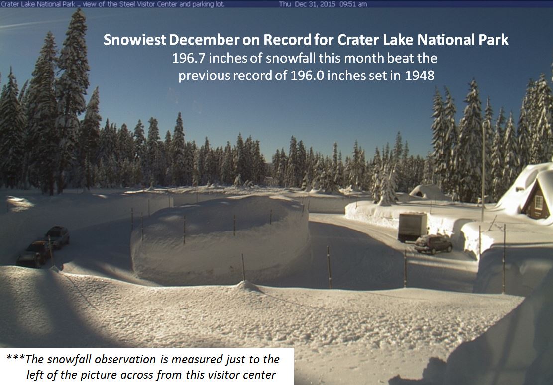
But, Crater Lake National Park out in Oregon is above average. After a record-setting December, this month has been an above average one as well. They have now tipped the scales at over 300" since the season began.
On the other hand, Mount Washington NH, home of the world's worst weather, has had below average snowfall. As I write this, only 85.0" has accumulated so far this season. A normal snow season is about 281". Of course, we still have a ways to go as February and March are typically snowy as well. And April is somewhat productive too.
I will say this though about Mount Washington. On January 19, the daytime high was -9 and the low temperature was -22. Winds gusted to 127 mph at the top of the 6,280 ft summit. The average temperature being -15 and the average wind speed at 86 mph produced an average wind chill of -60! Can you say ouch??
Looking ahead, the weather will be turning warmer as the AO which has been trending toward neutral should become positive for a brief time. Recall that I mentioned something about a transition, going from a negative state to a positive one can have exciting consequences for fans of winter weather. Well, you just got your reward. Now, the January Thaw will commence for a time before the next change or transition takes place.
It has something to do with the Polar Vortex. Ah, the infamous Polar Vortex. I can see it now. Hollywood is probably already coming up with a script where a fat man in a red suit is storm chasing and comes upon an abominable snowman-looking tornado near his home at the North Pole, doing everything he can to rescue his family and workers before disaster strikes, since they have poor cell phone reception and no outdoor sirens to alert the public for life-threatening weather emergencies.
Anyway, it will be turning much colder as we get into the month of February. My February prediction comes out later this week.
MS


No comments:
Post a Comment