Good Monday...My temperature is 32 degrees here at 7:30 this morning. The most important thing to me is it's clear, yes dry. Let me be the first to tell you, this guy is glad.
Louisville is on The Weather Channel this morning. Other national outlets have us on their cameras as well. For good reason, the Ohio River is cresting today with moderate flooding going on here in Louisville. I live about 4 miles away from the river. But, I do live near a creek that feeds the river. Since I live about a mile from there, I have not experienced any direct issues from the creek, which is still running high but is within its banks again. Yet, I had to battle a water table beneath the ground as saturated soils forced waters into a few of the small cracks in the foundation leading into my basement. Not much sleep, I can tell you that!
Here are some locations not too far from where I live here in Valley Station. These are totals since last Wednesday, February 21 through Sunday, February 25.
Total For TR01 - D. R. Guthrie WQTC 6.24 inches.
Total For TR02 - PRP Fire Station Training Facility 6.54 inches.
Total For TR03 - Shively PS 6.51 inches.
Total For TR11 - Northern Ditch PS 6.85 inches.
Total For TR12 - Nightingale PS 6.83 inches.
Total For TR14 - Lea Ann Way PS 6.75 inches.
Total For TR19 - Fairdale High School 6.74 inches.
Total For TR21 - Wheeler Basin 7.37 inches.
My 5-day total came to 6.77". The official site at Louisville's Standiford Field was 7.12".
For the month, Louisville has set an all-time wettest February record, and we're not done yet. At 10.47", more heavy rain may affect the region later this week. I haven't yet broke the 10" mark at my house but should likely gain ground by the last day of the month. If the rain is light as forecast for Wednesday, I will probably fall just short of that mark. Right now, I am at 9.52".
Here are those same areas above with their monthly totals....
Total For TR01 - D. R. Guthrie WQTC 8.18 inches.
Total For TR02 - PRP Fire Station Training Facility 9.83 inches.
Total For TR03 - Shively PS 9.71 inches.
Total For TR11 - Northern Ditch PS 10.12 inches.
Total For TR12 - Nightingale PS 10.62 inches
Total For TR14 - Lea Ann Way PS 10.36 inches
Total For TR19 - Fairdale High School 9.92 inches.
Total For TR21 - Wheeler Basin 10.56 inches.
As far as the week ahead is concerned, rainfall estimates of 0.75 to 1.50" can be expected from now through Friday, with heaviest amounts expected for the southern part of the state.
From a temperature perspective, I am making an official projection that Louisville will also finish in the top ten warmest February of all time. It looks to be near the middle of the list, like 6th. But, the numbers are very close to each other near the bottom, so a slight deviation may make a big impact on where at on the list we finish.
If Louisville does finish with a 45 degree average for the month, that would be nearly 6 degrees above normal. Let's add the December and January averages of -0.9 and -2.2, and we actually would end up with a 1 degree above normal meteorological winter. That's right. An above normal winter after all of the harsh single digit and, in some cases, below zero readings.
I'm pretty sure the Heat Island capital is not the only one who will have such a reversal from bitter cold to unusual warmth leading to an above normal winter.
Lexington, by the way welcome to the 10" February Precipitation club (you only need 0.05" to break an all-time February precipitation record), is already averaging 7.8 degrees above normal for February. This looks to offset the December and January averages for an above normal winter.
Bowling Green, Jackson, and even London should all finish above normal for the winter as well.
The Winter season precipitation records look to stay safe, but Louisville and Lexington will be pretty close to obtaining top ten status.
In addition, Paducah looks to have an above normal winter for temperatures, a near-record entry into the top ten snowiest winters, and a near-record entry into the Wettest Winter Season's top ten.
Also making national news were the tornadoes that hit in southwest KY and northwest TN as well as at least 3 tornadoes that hit parts of south central KY. One fatality was associated with the EF-2 twister in Logan county in Adairville. In addition, Lewisburg in Logan county also had a confirmed tornado. Another tornado crossed between the Warren/Barren county lines near Smiths Grove. Hopkinsville, Murray, and Lone Oak also had confirmed tornadoes in the western part of the state. More surveys will be conducted today.
I hate to say this, but it looks like another active severe weather season is commencing, just in time for the upcoming Spring .
Hang in there guys. Have a good week everyone. Stay safe and out of flooded roadways.
MS
Monday, February 26, 2018
Thursday, February 22, 2018
The Great Swell 2018...with Updated Rain Amounts
Scroll down for the latest information...
Good morning. It appears Round 1 is winding down. I took the liberty to jot down a few totals since yesterday. Starting with the most important place, at my house (hey, this is my blog), I collected 2.25" as of 10:30 this morning. The Louisville International airport, at Standiford Field, came in at 2.37". Around Jefferson County, I'm getting reports of many 2.00 - 2.50" amounts since yesterday.
Also, a cursory glance at the official site appears to have set a daily rainfall record for today the 22nd. It looks like the daily record was beaten by 0.06". But, we'll have to wait and see how the weather observation records and climate records work this one out.
Other noteworthy locations include near Munfordville in Hart County. Last I checked, they were coming in at a total of 3.46", as of 11:00 a.m and since yesterday.
As of 11:00 this morning, Lexington has recorded 2.46" since midnight, good enough for a daily rainfall record for today the 22nd. Storm totals since yesterday have closed in on the 3" mark.
Rivers continue to swell statewide. River forecasts continue to inch higher, with some areas along the Ohio possibly reaching moderate flood stage. If this occurs, it will have been since 2011 since river levels have been this high.
UPDATE 02/22 142800...Upper Gage at McAlpine now forecast to crest at 34.4 ft by Tuesday; many floodgates closed
UPDATE 02/22 145600...Lower Gage now forecast crest of 65.9 ft; at 66 feet Riverport floodgate closes
Looking at crests on Ohio River McAlpine Upper
Historic Crests (1) 52.15 ft on 01/27/1937
(2) 42.10 ft on 03/08/1945
(3) 41.70 ft on 02/16/1884
(4) 41.20 ft on 03/12/1964
(5) 39.50 ft on 02/16/1883
(6) 39.40 ft on 04/02/1913
(7) 38.76 ft on 03/07/1997
(8) 36.40 ft on 01/22/1907
(9) 36.00 ft on 04/19/1948
(10) 34.10 ft on 03/23/1933
(11) 33.40 ft on 03/04/1962
(12) 33.00 ft on 05/10/1961
(13) 33.00 ft on 03/23/1943
(14) 32.40 ft on 02/22/1882
(15) 31.90 ft on 12/14/1978
(16) 31.80 ft on 03/10/1955
(17) 31.60 ft on 03/29/1936
(18) 31.50 ft on 03/13/1967
(19) 31.50 ft on 03/22/1963
(20) 31.40 ft on 02/07/1950
(21) 31.30 ft on 03/30/1898
(22) 31.13 ft on 04/27/2011
(23) 30.60 ft on 01/27/1927
(24) 30.40 ft on 03/28/1890
(25) 30.30 ft on 02/28/1897
(26) 30.10 ft on 02/09/1939
(27) 30.00 ft on 04/26/1940
UPDATE..02/23 105000.
Rainfall totals since last Wednesday as of approx. 10:30 a.m. est
Mayfield 6.36"
Hickman 5.79"
Madisonville 5.69"
Benton 5.36"
Greenville 5.01"
***Correction***...it appears some numbers above went back to last weekend, not Wednesday -MS
UPDATE...02/23 111500
I am still awaiting for the rain to exit, so I can take a measurement. It looks to be similar to nearby rain gauges in Jefferson County, between 3.50 and 4.00" since Wednesday. Louisville officially at 3.87" since Wednesday as of 10 a.m.
UPDATE...02/23 112500
Louisville is already at 8th wettest February on record
Lexington is now at #2 wettest February at 8.45" as of 11:00 a.m.
UPDATE...02/23 123000
As of 12:30 p.m., I have received 3.87" since Wednesday, including 1.62" since yesterday starting at 10:30 am.
Other areas surrounding me include PRP at 4.19"; Shively at 4.28"; Fairdale at 3.42"; Louisville International at 4.02" (12 noon reading)
UPDATE 02/23 130000
New river forecast crests for Louisville...McAlpine Upper 34.9; Lower 66.2 on Monday, both up slightly from previous forecast
UPDATE..02/24 094500
Total rainfall since Wednesday thru 9:00 am this morning
Paducah.........4.17"
Owensboro....4.12"
Louisville......4.12"
Including Mesonet sites, I've uncovered 14 additional locations exceeding 4" for the same time period...thru 10 am est.
Mayfield.......5.75"
Madisonville 5.74"
Hickman.......5.45"
Greenville.....5.35"
I will include an update on monthly totals later this morning/early afternoon, especially for candidates likely exceeding 10" for the month, which is a substantial list of at least 16 locations, three of which are already above 10".
UPDATE 02/24 135000
Ending at 12:30 pm est, I collected another 0.27" since yesterday, bringing my storm total to 4.14" in Valley Station at Prairie Village. Louisville is now up to 4.29" through 12 noon. Other locations surrounding me are PRP near Ohio River at 4.51" through 1:45 pm; Shively at 4.55"; Fairdale at 3.63"; Valley Station near Ohio River at 4.19".
As promised, monthly totals for our region include 3 locations that have already recorded amounts greater than 10"; Knox County at Barbourville, McCreary County at Whitley City, and Harlan County atop Black Mountain. However, other locations have registered amounts greater than 8" and stand the best chance to record double digit monthly totals. Here are the most recent totals...
Greenville (2:20pm est)...9.04"
Lexington (2:00pm est)...8.98"
Mayfield (2:15pm est)...8.92"
Albany (2:30pm est)...8.85"
Madisonville (2:15pm est) ...8.81"
Lebanon (2:35pm est)...8.79"
Hodgenville (2:30pm est) 8.72"
Cadiz (2:20pm est)...8.70"
Murray (2:15pm est)...8.60"
Hardinsburg (2:25pm est) 8.57"
Shepherdsville (2;25pm est) 8.54"
Tomkinsville (2:40pm est) 8.42"
Brandenburg (2:35pm est) 8.34"
Also, chances are increasing for another significant rain event next week, which may include several other locations that may top the 10" monthly mark. This will quite likely be Kentucky's wettest February ever.
UPDATE 02/25 015000
Louisville sets another daily precipitation record and an all-time wettest February on record, now well over 10" for the month. I really think forecast river crests may rise a little more than expected, especially downstream from Louisville
UPDATE 02/25 050000
At my house in Valley Station, I recorded 2.63" since 12:30pm. That added to the 4.14" since Wednesday gives me 6.77".
I will post more rain totals on this page throughout the weekend.
Turn around. Don't drown.
MS
Monday, February 19, 2018
MikJournal Monday 02/19/2018...Extremes
Last evening, the temperature was about 48 degrees here at my house. I read the forecast for an overnight low of 47 and obviously had my doubts. Well, I awoke this morning to a temperature of 58 degrees. As I write this post, the temperature has actually risen to 59, and it's not even sunrise.
What a rollercoaster month! Starting out the month, temperatures were very cold. In Louisville, a high of 28 and a low of 14 gave us an average temperature of 21, nearly 15 degrees below normal. On the 15th of this month, a high of 74 and a low of 62 for an average of 68 degrees, some 29 degrees above normal. Then, over the weekend, a surprise snow for my area, almost a half inch, with temperatures above freezing the entire time. Now, forecasts are for more 70's this upcoming week. Breathe.
Unfortunately, heavy rains are poised to move back into our region. The Mesonet site in Harlan County, up near 4000 feet atop Black Mountain, has already received 11.71" for the month, part of an impressive flooding situation along the Cumberland river and other nearby tributaries.
Rainfall estimates for last week were for a general 1-3". In Louisville, 1.61" fell since last Monday. At my house, just 10 miles away, I collected 1.50". In the eastern part of the state 2-3" were quite common.
This week, the situation becomes dire, especially along the larger river systems, like the Kentucky and Ohio rivers. Thanks to the heavy rains from last week and swollen rivers upstream, these have flowed into the larger river systems, which has already prompted flood warnings for many along the Ohio. And the forecast for the week, well, you take a look...

For central and west Kentucky, rainfall projections of at least 5" for the week will likely lead to flash flooding and areal flooding for many. Residents of eastern Kentucky cannot let their guard down either. Another 2-3" is forecast for the upcoming week. A reminder to all of us. This forecast is not set in stone. Yes, a general 2-5" is expected for the week. But, the axis of the heaviest rainfall is still uncertain. Stay tuned to your favorite media source for the latest updates.
Talk about extremes. Just recently, I highlighted in one of my posts, that here in Louisville, we had 9 days in January when temperatures were in the single digits, placing us in a small number of years that event has occurred in Louisville's climatological history, including the first time in the 2000's.
Now, we're talking about the other extreme. There is a measure called the Cooling Degree Day, used for energy purposes. But, it is based on an average temperature of 65 degrees. So, if you have a high temperature of 75 and a low temperature of 55, the average temperature would be 65 degrees. Now, that sounds pretty good for Spring. But, for February, that's a pretty rare achievement.
As I noted earlier in this post, on the 15th, Louisville had a high of 74 and a low of 62 for an average of 68 degrees. That gave us 3 Cooling Degree Days or CDD's. That means our average temperature was 3 degrees above the 65 degree base. Anytime the average temperature is greater than 65 degrees for a particular day, that will be added to the 3 we already have at present.
Well, how rare is that for February? In the table below, I collected some CDD's from years past for Louisville. Here, take a look....
Remember, Louisville has already recorded 3 CDD's for this month. Therefore, we already are in 3rd or 4th place according to this table. With temperatures projected well into the 70's and lows in the 60's for at least a couple of days this week, we will likely see average temperatures greater than that 65 degree base. My current projection is that Louisville will set an all-time mark for most CDD's for the month of February, possibly between 6 and 8 total CDD's.
What will this unusual warmth do for our overall winter? December and January were below normal. February started out way below normal. But, now it appears that February will have a much above normal month for temperatures. Wouldn't it be crazy if our overall winter average came in above normal because one month, or should I say, a few days of the month, skewed the entire winter to above normal?
But, Old Man Winter may make another appearance around here soon enough. Does he have plans to wreck that possibility of a warmer than normal winter? Teleconnection signals are like security cameras and they already have him on the monitor. We'll just have to wait and see what he is up to.
For now, take care. Stay safe. Do not cross flooded roadways. It is not worth it. Even if the idiot ahead of you attempts it successfully does not guarantee that you will make it.
MS
What a rollercoaster month! Starting out the month, temperatures were very cold. In Louisville, a high of 28 and a low of 14 gave us an average temperature of 21, nearly 15 degrees below normal. On the 15th of this month, a high of 74 and a low of 62 for an average of 68 degrees, some 29 degrees above normal. Then, over the weekend, a surprise snow for my area, almost a half inch, with temperatures above freezing the entire time. Now, forecasts are for more 70's this upcoming week. Breathe.
Unfortunately, heavy rains are poised to move back into our region. The Mesonet site in Harlan County, up near 4000 feet atop Black Mountain, has already received 11.71" for the month, part of an impressive flooding situation along the Cumberland river and other nearby tributaries.
Rainfall estimates for last week were for a general 1-3". In Louisville, 1.61" fell since last Monday. At my house, just 10 miles away, I collected 1.50". In the eastern part of the state 2-3" were quite common.
This week, the situation becomes dire, especially along the larger river systems, like the Kentucky and Ohio rivers. Thanks to the heavy rains from last week and swollen rivers upstream, these have flowed into the larger river systems, which has already prompted flood warnings for many along the Ohio. And the forecast for the week, well, you take a look...

For central and west Kentucky, rainfall projections of at least 5" for the week will likely lead to flash flooding and areal flooding for many. Residents of eastern Kentucky cannot let their guard down either. Another 2-3" is forecast for the upcoming week. A reminder to all of us. This forecast is not set in stone. Yes, a general 2-5" is expected for the week. But, the axis of the heaviest rainfall is still uncertain. Stay tuned to your favorite media source for the latest updates.
Talk about extremes. Just recently, I highlighted in one of my posts, that here in Louisville, we had 9 days in January when temperatures were in the single digits, placing us in a small number of years that event has occurred in Louisville's climatological history, including the first time in the 2000's.
Now, we're talking about the other extreme. There is a measure called the Cooling Degree Day, used for energy purposes. But, it is based on an average temperature of 65 degrees. So, if you have a high temperature of 75 and a low temperature of 55, the average temperature would be 65 degrees. Now, that sounds pretty good for Spring. But, for February, that's a pretty rare achievement.
As I noted earlier in this post, on the 15th, Louisville had a high of 74 and a low of 62 for an average of 68 degrees. That gave us 3 Cooling Degree Days or CDD's. That means our average temperature was 3 degrees above the 65 degree base. Anytime the average temperature is greater than 65 degrees for a particular day, that will be added to the 3 we already have at present.
Well, how rare is that for February? In the table below, I collected some CDD's from years past for Louisville. Here, take a look....
|
2017
|
5 |
| 1932 | 5 |
| 2000 | 4 |
| 1985 | 2 |
| 1954 | 2 |
| 1883 | 2 |
Remember, Louisville has already recorded 3 CDD's for this month. Therefore, we already are in 3rd or 4th place according to this table. With temperatures projected well into the 70's and lows in the 60's for at least a couple of days this week, we will likely see average temperatures greater than that 65 degree base. My current projection is that Louisville will set an all-time mark for most CDD's for the month of February, possibly between 6 and 8 total CDD's.
What will this unusual warmth do for our overall winter? December and January were below normal. February started out way below normal. But, now it appears that February will have a much above normal month for temperatures. Wouldn't it be crazy if our overall winter average came in above normal because one month, or should I say, a few days of the month, skewed the entire winter to above normal?
But, Old Man Winter may make another appearance around here soon enough. Does he have plans to wreck that possibility of a warmer than normal winter? Teleconnection signals are like security cameras and they already have him on the monitor. We'll just have to wait and see what he is up to.
For now, take care. Stay safe. Do not cross flooded roadways. It is not worth it. Even if the idiot ahead of you attempts it successfully does not guarantee that you will make it.
MS
Monday, February 12, 2018
MikJournal Monday 02/12/2018...Lake Effect Snows
Good Monday to you. Well, I awoke to a clear sky and a seemingly dry porch and a temperature of 24 degrees. Then, I checked my phone and saw a message from the school system that area schools were closed. I checked a news app and saw that several school districts were closed today. Still not quite understanding why, I checked out a local news media outlet and finally understood what the fuss was all about.
That seemingly dry porch of mine actually had patches of a thin layer of ice due to sleet and freezing drizzle last night. In fact, area roadways were impacted for this morning's rush hour, which was anything but rushing, more like crawling. Good. Motorists were actually trying to behave themselves for a change.
Looking ahead to the rest of this week, temperatures are going to warm up but at a price. The atmospheric setup is one that favors funneling an abundant supply of moisture into our region, which is not good for our friends in the southern and southeastern parts of the state.
The Weather Prediction Center is forecasting an additional 1-3" for the state, possibly exasperating already swollen river systems for residents in the eastern part of the state.

In an ironic twist, some areas of eastern KY have seen more rainfall this month already than a season's worth of snowfall. For example, Skyline in eastern Kentucky has received 5.32" of precipitation (mostly rain) this month while recording only 4.5" of snowfall since the snow season began July 1. That 4.5" of snowfall is about 8 inches below normal. With a couple of exceptions, many in the Bluegrass state are experiencing another below normal winter for snow lovers.
But, there are some places in the U.S. that are enjoying (or dreading) another banner year for snowfall. Last year, the state of Maine saw many locations exceed 100" for the snow season, well above normal. How about this year?
Several locations in Maine are already ahead of schedule for an above normal snowfall. In fact, some areas are on track to exceed the winter of 2007/2008 totals when places like Caribou saw nearly 198".
Actually, it appears some areas may approach last year's totals while others may not be as robust. Still, an above normal snow season nonetheless.
How about the Lake Effect Snow Machine? Erie, Pennsylvania has already set an all-time record snowfall for the season and will likely add to it over the next couple of months. Yet, Erie is not the only one having a blockbuster season. The usual locations I follow in New York are at it again. Near Hooker, snowfall totals for the season have already exceeded 183", beating out Erie by nearly 30". In fact, the snowiest season on record near Hooker was 466.9" during the winter of 1976/77 followed by another 418.4" the following winter of 1977/78. So, last year's total of 237" or so was a little bit below normal for the data obtained over the last 60+ years. Still, even they are on track to register a near normal snowfall of 246" for this winter.
You can follow the stats on the side of the blog for the next couple of months. Hopefully, I'll be able to update some mountain snowfall totals, especially out west.
Have a nice week everyone. Remember, do not cross flooded roadways, especially barricaded roads, since you have no idea whether the road underneath exists.
MS
Monday, February 5, 2018
MikJournal Monday 02/05/2018...Space Shuttle Columbia Disaster 2003 and February Outlook
Good Monday to you. I wanted to share a little bit of history with you. 15 years ago on February 1, the Space Shuttle Columbia was attempting to re-enter Earth's atmosphere but disintegrated. What does this have to with weather you may ask?
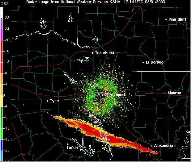
Look at this radar image, just moments after it was determined the shuttle and its crew did not make it safely through re-entry...
Friends, that's not rain nor is it rainfall anomalies. It is an image of the debris field left behind when the shuttle disintegrated. The distance spanned was enormous, from Tyler in Texas to western Louisiana. In fact, debris was still being obtained some 8 years after the disaster. However, only about 40 percent of the craft has been recovered. It is speculated that either the majority of the structure likely burned up during the re-entry process or there may be still smaller fragments out there in sparsely populated or unreachable regions. Thanks and credit Matt Lanza for posting the radar image on Twitter.
FEBRUARY OUTLOOK
As usual, I'm a little late with my outlook. One winter storm just fizzled out for us over the Super Bowl weekend, but not before producing over 2" of wet snow in some locations. The teleconnection signals gave mixed signals. The PNA and AO continue to give mixed signals and have both offered up potential for this upcoming week of February 5-11.
One is coming up late on the 6th into the 7th. The next one will be a few days after that one. It is possible some may get a decent snowfall out of this. But, indications are leaning toward a warmer solution which may involve ice or rain.
I think we will see above normal temperatures coming soon. However, that pattern may lead to a sudden flipping later this month, yes, more cold air poised to dive southward. Right now, I do not see any significant snowfall after the middle of the month. But, if cold air will be present later this month, clipper type systems could produce a varied amount of snowfall for our region. We will just have to wait and see how those events unfold.
La Nina conditions will likely be contributing to another active severe weather season. It's still too vague if we will see any severe weather here in our region this month. But, March may be a stormy month.
Have a good week everyone and congrats to the Super Bowl champions Philadelphia Eagles.
MS
Subscribe to:
Posts (Atom)
-
 In July of this year, I did a segment about the latest sunsets in the eastern time zone. This corresponded nicely with the summer solstice a...
 -
Recently, I noticed that our days have now begun to shorten. However, our sunset here in Louisville still remains at 9:10pm edt. Starting th...
-
A 1 Temperature C Humidity F Heat Index 2 81 82 86.82 This is an Excel spreadsheet program. Fairly ...
