Good morning to ya! Another in a series of beautiful spring days is on tap for us again today. I'm telling you, after a mostly cooler than normal start to the first several days of the month, I simply cannot recall a more amazing stretch of days we have enjoyed for a Spring season. But, as the saying goes, 'All good things must...', well, I don't want to see this come to an end, but change looks inevitable.
Our temperatures today look to rise into the summertime range. After that, our lovely little pattern takes a turn for the ugly side.
The Climate Prediction Center has posted its 6-10 day outlook and its 8-14 day outlook regarding temperatures and precipitation. A transition to cooler than normal temperatures will really set in as we get into the first part of May with a good chance of above normal precipitation.
At this point, I cannot say we will see sleet or anything wintry during that time frame, but the air will take on a more noticeable chill. In addition, with lingering clouds and light rain/drizzle the day after a frontal passage then throw in some brisk northerly winds, our May temperatures may struggle through the 50's for highs at times. Hopefully, this type of stuff will break by the time we get closer to the Oaks and Derby.
Besides the temperatures decreasing, precipitation chances look to increase over the next several days.
In fact a severe weather outbreak may begin as early as tomorrow in parts of Kansas and Oklahoma. along a generally w-e frontal orientation. This may create a multi-episodic scenario of severe weather and heavy rainfall.
During the next several days, we could see numerous chances for rainfall and perhaps severe weather at times. Any timing for severe weather would be largely dependent on meeting many factors, including instability. At any rate, it will become a more stormy pattern than what we have been seeing lately.
I will be presenting a large write-up for the 5-year anniversary of the historic tornado outbreak that happened on Wednesday, April 27, 2011 and affected much of central Alabama, including Birmingham and Tuscaloosa.
Look for it on the MikJournal's Historical Humpdays segment this Wednesday.
Otherwise, have a great day. I owe my little girl an ice cream for her good report card from a few weeks ago. We actually took her shortly after she received it, but Graeters forgot to give us the free ice cream for her when they rang up the bill. So, we get to go back. Shucks.
MS
Monday, April 25, 2016
Wednesday, April 20, 2016
Historical Humpdays 04/20/2011 Tornado Outbreak in Kentucky and Southern Indiana
Tuesday/Wednesday April 19-20, 2011
Kentucky/Southern Indiana Historic Tornado Outbreak
The event only lasted about 4 hours; however, it would produce at least 2 dozen confirmed tornadoes, as the NWS offices would uncover.
There were several tornadoes that occurred over Southern Indiana, late in the evening on the 19th. Listed below are a few examples....
Between 10:30 and 11:00 p.m., in Orange County near Greenbrier, an EF-1 tornado with winds approaching 125 mph damaged or destroyed at least 4 metal barns or outbuildings, even tossing one of them 300 yards downwind. Trees were uprooted in a convergent pattern, a strong indicator that a tornado was present, as the uprooted trees were pointing toward a central location. Straight-line winds show damage of uprooted trees blown down facing only the opposite direction from which a damaging wind segment occurs, not blown down toward the wind source.
The same tornadic cell may have briefly lifted but touched down again for a brief period of time near Greenbrier and destroyed a metal roof barn while ripping off the front porch of another house and depositing it in the back yard. In addition, several tall evergreens were snapped off and thrown chaotically in all directions. The second touchdown apparently had winds of about 110 mph producing EF-1 damage.
About 11:00 p.m., in Washington County, near Livonia, an EF-1 tornado with wind speeds up to 100 mph destroyed a grain bin, then two silos and a 20 x 30 ft outbuilding. One home that was seriously damaged not only had the roof peeled back, but the home was pelted with flying gravel as the tornado lifted it from the driveway and pinged the home as with multiple slingshots.
Then, in Scott County, near Scottsburg, between 11:00 and 11:30 p.m., an EF-0 tornado with wind speeds up to 80 mph damaged the exterior wall panels of a Holiday Inn
Additional tornadoes were reported in Jefferson County Indiana, also in Clark County near the Jeffersonville airport.
In Central Kentucky, confirmed tornadoes in Breckinridge and Meade counties occurred just before midnight as well as an EF-1 tornado in Oldham County that destroyed a barn and damaged another later.
After midnight, in Franklin County, near the Frankfort Capitol building, an EF-0 tornado with wind speeds up to 70 mph caused minor damage to homes.
Also, near Georgetown in Scott County, an EF-1 tornado with wind speeds up to 95 mph caused extensive damage to a tied-down trailer and outbuildings as well as buckling the brick garage wall of a well-built home.
In addition to the tornadoes which by the way did not cause any injuries or deaths, widespread wind damage occurred in many places along that intense squall line.
Even in Central Alabama like Tuscaloosa, they would see widespread wind damage with speeds up to 75 mph.
Little did they know but in exactly one week on the 27th of the month, a historic tornado outbreak would affect Central Alabama, including the major cities of Tuscaloosa and Birmingham. This will be the focus of my next Historical Humpdays segment. I will have a large write-up for the 5-year anniversary and hope you get a chance to review it.
Thanks to the storm reports from the NCDC's Storm Data publication from April 2011
MS
Monday, April 18, 2016
MikJournal Monday 04/18/16
What another beautiful start to the day, unless of course you have to pay your tax liability today.. Spring is making up for lost time after a seemingly long hiatus during most of the first half of the month.
A beautiful blue sky and a crystal clear night have dominated the weather forecast for a few days. Warm days and pleasantly cool mornings are just perfect for me.
Hey, did you get a chance to view last night's spectacular display of the bright International Space Station crossing the sky in the same vicinity of the moon and Jupiter? It really was a special treat, since I had no idea the three objects were going to share such a small part of the sky together.
What made this more interesting was other objects were crossing the sky at about the same time frame, possibly an airplane. As it traversed across the sky, it suddenly brightened then gradually dimmed over the next several seconds, briefly being illuminated by the sun (that had already set over a half hour earlier) during that time.
From the friendly skies to the ground below was an exceptional weekend for our region, but...
The skies were not so friendly over the weekend for parts of the Rockies and the Texas/Oklahoma regions.
In and around the Denver area, snowfall amounts in excess of a foot have caused some travel issues, including airport delays at the Stapleton Airport in Denver.
I have seen some reports of over 4 feet, just from this past weekend storm...
While April snowstorms are not uncommon in these areas, the amounts seen over the weekend were nothing short of amazing.
Denver, at 12.1" for the weekend, recently reached a high of 77 degrees last Thursday on the 14th. What a turnaround!
On the spring side of things, dangerous flooding conditions are currently ongoing in parts of east Texas, especially.
I was just reading some of the storm reports from the Houston/Galveston NWS office. Road closures, water rescues, up to 70 subdivisions now flooded in Houston, water even flowing over part of Interstate 10, and the rain does not appear to be abating anytime soon.
The rainfall began picking up in intensity just a few hours ago in Houston, where nearly 4" has fallen in the last 3 hours or so with heavy rain continuing to fall.
Radar estimates of rainfall since Saturday morning show over a foot of rain has occurred west of Houston.
A massive ridge in the east, partly responsible for our lovely weather, has kept the bulk of the rain confined to the same locations for the past few days.
From the Dallas/Fort Worth NWS office, rainfall amounts of 3-7" were common over the weekend. That system is what is now affecting Houston and will slowly trek east as the ridge finally begins to break down.
Finally, believe it or not, we are still dealing with a strong El Nino. However, it is weakening. The numbers have shown a 50% retracement from its mean high in the Nino 3-4 region. Therefore, the running mean (generally 3 months) will continue its downward spiral.
In fact, later on this year, we could be looking at La Nina conditions, which may make for an interesting winter and severe weather season next spring.
There's your long-range outlook. Now, if I can only predict what's going to happen this week....
MS
A beautiful blue sky and a crystal clear night have dominated the weather forecast for a few days. Warm days and pleasantly cool mornings are just perfect for me.
Hey, did you get a chance to view last night's spectacular display of the bright International Space Station crossing the sky in the same vicinity of the moon and Jupiter? It really was a special treat, since I had no idea the three objects were going to share such a small part of the sky together.
What made this more interesting was other objects were crossing the sky at about the same time frame, possibly an airplane. As it traversed across the sky, it suddenly brightened then gradually dimmed over the next several seconds, briefly being illuminated by the sun (that had already set over a half hour earlier) during that time.
From the friendly skies to the ground below was an exceptional weekend for our region, but...
The skies were not so friendly over the weekend for parts of the Rockies and the Texas/Oklahoma regions.
In and around the Denver area, snowfall amounts in excess of a foot have caused some travel issues, including airport delays at the Stapleton Airport in Denver.
I have seen some reports of over 4 feet, just from this past weekend storm...
| Listed Below is a small sample of Total Snowfall Reports | |||||||||||||||||||||||||||||||||||||||||||||||||
|
While April snowstorms are not uncommon in these areas, the amounts seen over the weekend were nothing short of amazing.
Denver, at 12.1" for the weekend, recently reached a high of 77 degrees last Thursday on the 14th. What a turnaround!
On the spring side of things, dangerous flooding conditions are currently ongoing in parts of east Texas, especially.
I was just reading some of the storm reports from the Houston/Galveston NWS office. Road closures, water rescues, up to 70 subdivisions now flooded in Houston, water even flowing over part of Interstate 10, and the rain does not appear to be abating anytime soon.
The rainfall began picking up in intensity just a few hours ago in Houston, where nearly 4" has fallen in the last 3 hours or so with heavy rain continuing to fall.
Radar estimates of rainfall since Saturday morning show over a foot of rain has occurred west of Houston.
A massive ridge in the east, partly responsible for our lovely weather, has kept the bulk of the rain confined to the same locations for the past few days.
From the Dallas/Fort Worth NWS office, rainfall amounts of 3-7" were common over the weekend. That system is what is now affecting Houston and will slowly trek east as the ridge finally begins to break down.
Finally, believe it or not, we are still dealing with a strong El Nino. However, it is weakening. The numbers have shown a 50% retracement from its mean high in the Nino 3-4 region. Therefore, the running mean (generally 3 months) will continue its downward spiral.
In fact, later on this year, we could be looking at La Nina conditions, which may make for an interesting winter and severe weather season next spring.
There's your long-range outlook. Now, if I can only predict what's going to happen this week....
MS
Friday, April 15, 2016
Severe Earthquake Rocks Japan
7.0 quake not very deep
Epicenter near Kumamoto...population of about 750,000 (734,000 in 2010)
Nearby locations include Nagasaki
Same region hit by a 6.2 tremor that killed at least 9 people recently.
MS
Epicenter near Kumamoto...population of about 750,000 (734,000 in 2010)
Nearby locations include Nagasaki
Same region hit by a 6.2 tremor that killed at least 9 people recently.
MS
Wednesday, April 13, 2016
Historical Humpdays - 04/13/1983 Twin Cities Record Snow
Wednesday-Thursday, April 13-14 1983
Twin Cities of Minneapolis-St. Paul
It started out innocently enough on the 13th as rain. But, by the time residents woke up Thursday morning, they were astonished by the 13.6" of snow accumulation glistening in the bright morning sun.
The southwest part of the state would experience the brunt of this strong storm system on Wednesday as snow and blowing snow created hazardous driving conditions. Soon though, the southeast part of the state was smacked with changing weather conditions for the overnight period.
A wet, heavy snow piled up a slushy accumulation on area roadways before freezing. However, for roadways that were cleared before the temperatures crashed, a washboard effect was created as the ripples of the pavement felt like you were driving somewhere out in the country on a dirt or gravel road.
Winds of 40-50 mph restricted visibilities, making for near blizzard type conditions. In addition, a 90-foot light tower succumbed to the high winds at a municipal stadium. Power outages were quite common throughout the region.
The fairly new Metrodome roof was deflated because of a tear from the heavy weight of the snow by Thursday.
Hundreds of school districts closed classes for the day on Thursday.
That April snowstorm for the Twin Cities would contribute to the snowiest April on record as over 21" eventually fell there.
From the archives of NCDC's Storm Data publication April 1983 Volume 25 No.4
http://www1.ncdc.noaa.gov/pub/orders/IPS/IPS-75895F08-6EA0-4494-813C-6EDCC44FB8B4.pdf
MS
Monday, April 11, 2016
U.S. Weather 50 Years Ago
Have you ever wondered what the weather was like a long time ago when the 'hottest year on record' was not being set every year?
How about 50 years ago? Yes, the year 1966.
U.S. population - 196.56 million
Cost of a new home - $23,300
Cost of regular gas per gallon - $0.32
Cost of one dozen eggs - $0.60
Cost of one gallon milk - $0.99
How about 50 years ago? Yes, the year 1966.
U.S. population - 196.56 million
Cost of a new home - $23,300
Cost of regular gas per gallon - $0.32
Cost of one dozen eggs - $0.60
Cost of one gallon milk - $0.99
Calendar for April 1966 (United States)
| April | ||||||||||||||||||||||||||||||||||||||||||
|---|---|---|---|---|---|---|---|---|---|---|---|---|---|---|---|---|---|---|---|---|---|---|---|---|---|---|---|---|---|---|---|---|---|---|---|---|---|---|---|---|---|---|
| ||||||||||||||||||||||||||||||||||||||||||
Phases of the Moon: 5:
| ||||||||||||||||||||||||||||||||||||||||||
Holidays and Observances: 10: Easter Sunday
Well, what happened on this date, April 11 in 1966?
Jack Nicklaus wins the Masters Golf Tournament...again
Emmett Ashford becomes the first black Major League Baseball umpire
Frank Sinatra records "Strangers in the Night" hit single
Of course, what about the weather during the week of April 11?
April 11
Huntsville and Georgetown, AL - 1.5" - 4" diameter hail covered the ground to a depth of 2".
The very next day on the 12th, a tornado would touch down in Sheridan destroying 7 homes, a church, and a barn. In addition, 5.5" diameter hail caused damage to metal awnings, windshields, and roofs, also in Sheridan.
Denver, CO - A funnel touched down in an open area in southeast Denver. Additional funnels would be observed in nearby counties for the next few days. One week from today, a massive snowstorm would bury many parts of the state.
Oklahoma - around the Tulsa area, hail damage was widespread. Hardest hit area was the Choteau region where average hail diameter was 1.5" and covered the ground with up to 8" drifts. The largest stones were 3.5" in diameter and caused extensive damage to cars, homes, and businesses. Also, straight-line winds of 60-80 mph along with some tornado damage and hail damage would pummel other parts of the state for the next couple of days.
Oklahoma - near Coweta, a tornado tore up bits of an asphalt highway, stranded 3 fishermen who were hanging onto trees while the funnel was overhead, demolished several structures, injured one from a toppled tree onto a storm cellar door, injured a child from a family of 11 who were taking shelter under and between their beds as the house was leveled, injured a woman taking cover under a bridge, and injured 3 youths when two cars went into ditches trying to flee from the funnel. (It almost sounds like scenes from a Hollywood production).
Texas - During the week, some hail damage to roofs in the Houston area and 4-6" rain fell within a 12-hour period on the 14th. In nearby Wharton, there was tornado damage to barns and homes. In one instance, a garage and trailer were demolished at a home, but the automobile inside the garage did not receive a scratch. Unfortunately, there were two deaths, related to drownings. One was in Galveston Bay, when a boat capsized during a squall, and the other when a car was swept into a flooded underpass in Mexia.
Locally, here is a brief snapshot of Louisville's weather for the month coming into the 11th, 50 years ago....
The average temperature was over 10 degrees below normal for the month.
Precipitation was about 0.50", or about 0.75" below average.
For the year, temperatures were running about 5.3 degrees below average and precipitation was about a half inch above average.
For the week of April 11, Louisville would endure 3 consecutive days of rain, a cold rain at that, with temperatures remaining in the low to mid 40's, eventually moderating into the mid to upper 60's by the end of the weekend dotted with a few cold mornings in the low to mid 30's.
After that week, Spring seemed to kick into gear as the rest of the month would see above average temperatures for the most part. Still, the month would finish 4.6 degrees below average.
However, April would prove to be a very wet month. The 9.56" monthly total stands at #4 on the all-time wettest April's list.
MS
|
MikJournal Monday 04/11/16
Good morning and welcome to another Spring edition of the MikJournal. Finally, it appears that Spring will come back after all. After a balmy March locally and nationwide, Spring kinda dropped the mic and walked away.
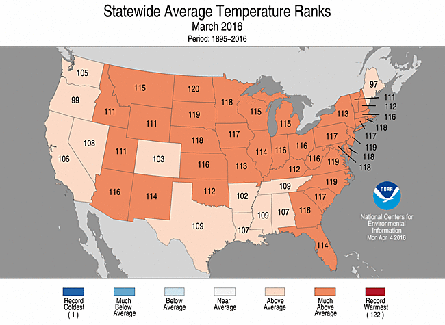
All those numbers show that the U.S. had above average to much above average temperature ranks throughout the 122 year history from 1895 to present. For Kentucky, our state registered a 112, which means that there have only been about 10 other March's either just as warm or warmer than this past March.
However, during April so far, it really does seem like Spring has 'walked away', uh, maybe got lost along the way, or has forgotten about us here in Kentucky. But, there are indications Spring is coming back.
The latest outlook from the good folks at the Climate Prediction Center shows a decent chance of above average temperatures over the next two weeks. Now, that does not mean we could not have a cooldown during that period. But, overall, temperatures are expected to average out above normal.
The longer daylight hours will eventually win out anyway and temperatures will respond. In fact, I believe all of this cold talk we've been dealing with will be a distant memory by late Spring into Summer. Although not an official prediction, I am seeing indications of a hot summer.
Could it be a top ten hottest summer? It's possible...but it depends on how dry the summer will become. Large fluctuations in daytime highs and nighttime lows in summer are generally an indication of a dry ground that keeps the average temperature lower than the usual 'hot and humid' days when temperature fluctuations are much smaller.
For example, a hot and humid day with a high of 93 and a low of 75 gives an average temperature of 84 degrees. Ick!! But a daytime high of 92 and a low of 62 would yield an average of 77 degrees, seven degrees cooler on average and 10-15 degrees cooler from a dewpoint perspective, which may seem nearly refreshing.
Right now, I am leaning more toward a hot and drier summer, not too good for us gardeners.
On a side note, I was talking about longer daylight hours just a moment ago. Barrow Alaska emerged from a sunless sky on January 23. Today, their daylength will be right around 16 hours. Adding 10-12 minutes per day of daylight over the next two weeks, the length of day will be around 18.5 hours by the 25th.
In fact, by the end of this month, the sun will not set till after midnight. Then, by May 11, in just one month, the sun will not set at all until about August 1.
Finally, mark this on your calendars. MAY 9, 2016 - The planet Mercury will be making a transit across the sky. Okay, nothing new there, but the sun will also be in the same vicinity of the sky. In fact, Mercury will appear as a rather large sunspot moving along the surface of the sun.
More information here.
Local viewing information for Louisville (and still visible statewide) click here.
Have a good week everybody.
MS
Monday, April 4, 2016
MikJournal Monday 04/04/16
Welcome to '4 squared day'. Sorry, the math geek in me saw the date 04-04-16 and decided that meant 4 times 4 equals 16 or 4 squared equals 16. The next 'squared day' won't be until May 5, 2025 or 05-05-25.
Anyway, what a wild weekend of wind and cold. Non-thunderstorm wind gusts of 50 to nearly 70 mph produced multiple instances of tree damage and power disruptions across Kentucky, including at my home, where the power was out for a few hours. A rare high wind warning was issued for the area and proved to be the strongest non-thunderstorm winds since the remnants of Hurricane Ike in September 2008 that produced winds near hurricane force.
I recorded a temperature of 29 on Sunday morning, which was actually much milder than some of my surrounding locations. However, the frost was not too bad (at least at my house) perhaps due to the slackening wind and dry air. I have not noticed any significant damage to any of my trees or budding plants yet.
Of course, there will be more opportunities for a hard freeze this week, beginning tomorrow morning.
Elsewhere, winter weather advisories and borderline warnings have been issued for parts of the Northeast, including Buffalo.
High Wind products are in effect for parts of Montana. You think it's been windy here, here's one for you. Livingston, MT had an average wind speed of 15.6 mph for the month of March. There were at least 11 days when the winds gusted to 50 mph or greater. On the 10th of the month, an average wind speed of 38.1 mph was achieved with a peak gust of 67 mph, all of these were non-thunderstorm related.
Louisville's highest wind average normally occurs during March. Our wind averaged 9.5 mph while the Windy City of Chicago averaged 10.7 mph.
This month, Livingston is averaging 17.8 mph, Chicago is at 14.7, and Louisville is at 12.8.
FWIW, supposedly, Livingston MT is rated the third windiest city in the Continental U.S. based on actual wind speeds. I cannot verify how accurate that assessment is, but appears to be reasonable. Elevation at Livingston is around 4,500 feet, or a few hundred feet higher than our tallest mountain in eastern Kentucky, Black Mountain.
MS
Sunday, April 3, 2016
Thunder Days - More For a Better Garden
I am adding a NEW feature to my blog for the spring season that will be used throughout the growing season. You can find the 'Thunder Days' section on the right side of the blog page.
I collect rainwater for my garden, since I believe it is superior to regular tap water or spring water. But, if you want an extra kick, collect rainwater during a good old fashioned thunderstorm. Or if the garden has become established, a thunderstorm can help the garden soil replenish the needed nitrogen that help plants thrive.
The month of March had 5 'thunder days'. I believe that the growing season from early May through the first part of October (at least at my house) should average over 40 'thunder days'.
Of course, other factors go into making the garden a success such as reasonable summertime temperatures and regular feeding of all garden plants, but using stored rainwater during the developing and established stages and during dry periods have really helped my garden immensely over the past several years.
Typically, I plant my vegetables right around or just after Derby Day. This year's garden will feature peppers of all kinds, zucchini, tomatoes, sweet potatoes, and rosemary. I will also have potted containers of thyme and oregano.
Last year's garden performed very well overall. Some plants suffered from perhaps too much water as it was an unusually wet year.
I will provide an outlook soon for the growing season but fear this will be a tough year for us. More on that in a future post.
MS
Subscribe to:
Posts (Atom)
-
 In July of this year, I did a segment about the latest sunsets in the eastern time zone. This corresponded nicely with the summer solstice a...
 -
Recently, I noticed that our days have now begun to shorten. However, our sunset here in Louisville still remains at 9:10pm edt. Starting th...
-
A 1 Temperature C Humidity F Heat Index 2 81 82 86.82 This is an Excel spreadsheet program. Fairly ...
