So far, the lowest temperature this young winter season has been 20 at Louisville Int'l and 17 at Lexington. At this time, all models are in agreement that a shot of Arctic air is poised to plague the region resulting in perhaps the coldest air of the season. Daytime highs look to struggle to reach the freezing mark.
You would think snow chances would rate very high during this time frame. True, we may see a fetch of moisture off of the Great Lakes, but what we need is a storm system that gets its act together to produce a decent snow event here while the window of opportunity is open.
Most likely, this cold snap won't last long unless we get a strengthening block to our northeast, which models do hint at some blocking. We'll have to wait and see on that one.
Till then, enjoy the mild air. I think I may end up going hiking...
MS
Thursday, December 29, 2011
Tuesday, December 27, 2011
Cold Front Pushing Through (9:45am UPDATE)
As I'm typing this, the cold front is literally over top of my location here just outside of Louisville. Winds have just shifted around to the west from the south.
This is verified by the SPC Mesoanalysis page looking at the 850mb sounding for 9am. The 'zero' line resided just west of Louisville and extended to Bowling Green, where their temps were in the mid 40's.
Moderate snow falling at Paducah, while light snow is falling at Indianapolis. Only rain being reported at Evansville but should have changeover by next hour.

Newburgh IN above
Here's a cool link to Vincennes IN live streaming webcam where snow has fallen this morning and produced a nice coating.
http://www.webcamvue.com/default.asp?webcam=hyObihvBIehN
More updates later...
MS
This is verified by the SPC Mesoanalysis page looking at the 850mb sounding for 9am. The 'zero' line resided just west of Louisville and extended to Bowling Green, where their temps were in the mid 40's.
Moderate snow falling at Paducah, while light snow is falling at Indianapolis. Only rain being reported at Evansville but should have changeover by next hour.
Newburgh IN above
Here's a cool link to Vincennes IN live streaming webcam where snow has fallen this morning and produced a nice coating.
http://www.webcamvue.com/default.asp?webcam=hyObihvBIehN
More updates later...
MS
Monday, December 26, 2011
Running With the NAM 12/27
The latest 06z run of the NAM is painting a clearer picture about what to expect from this next storm system, impacting the region mostly overnight and into the day on Tuesday.
Although I would like to review the next run (12z) of the NAM, I've seen enough trends from run to run that convinces me that this system will produce a rain and rain/snow event for the region.
However, for most, if not all of us, don't expect anything significant. Of course, we love surprises, though. This will be one of those instances where dynamic cooling can deal an interesting hand. There will be factors in play that could lend credence to this possibility...
1) Low pressure strengthening to our south
2) Freezing levels above ground level dropping throughout the day
3) Precipitation will still be in the region as the above factors play out.
In addition, a possible deformation zone could set up on the back side of the low thus producing an enhancement of rain/snow or whatever is falling at the time. If this should occur, it would most likely take place east and south of Louisville. Again, though, I like surprises.
Still, don't get too excited about this one as surface temps and wet grounds are not expected to support a nice, heavy wet snowfall. Please, surprise me.
MS
Sunday, December 25, 2011
GFS Model On A Roll
I have followed the GFS forecast model for the past two significant weather systems. Even though there were obvious flaws in presentation and consistency from run to run, its basic thought outclassed its 'foreign' competitors, the GEM and ECMWF, in the medium range forecasts.
There is another storm system lurking that should bring us precipitation during the day Tuesday, with changeover from rain to at least a mix of rain/snow quite possible by evening. Both the GFS and GEM are showing residual snow in the area Tuesday evening, primarily east of Louisville, that may include light accumulation. Considering a wet ground, any significant accumulation does not look likely unless any heavier bursts of snow that may develop cause deteriorating circumstances briefly.
However, the storm system looks to make a quick exit. There is no definitive TREND toward a colder pattern, based on my observations of the current NAO forecast. So far, the GFS forecast model and the NAO have provided me with the correct assumptions so far. Therefore, I'm sticking with them on this next system, as it has similar characteristics to previous systems.
So, expect rain with a good chance for at least mixed precipitation, possibly all snow toward the end of the storm system's influence on our region. Light accumulations are possible. Again, don't get too excited as the ground should be too wet and 'warm' for any decent, long-lasting sticking snows.
Of interest to me at present, is the NAM's forecast guidance. Look for their forecast at about 36 hours out to see the best scenario for our weather.
MS
Tuesday, December 20, 2011
12zGFS and Euro UPDATE
The latest GFS is out and its complete suite of data for this upcoming weekend, or should I say early next week?
While it seems the GFS has taken a verbal assault as of late, because of its crack-like mood swings, I thought the GFS was the first one to suggest a warmer solution to this week's storm system (the current storm system). And this was several days out. I have the maps to prove it. While not consistent in its presentation, the main thought was rain, not snow.
Can 'lightning strike twice in the same place'? Well, let's see what the latest run suggests. As you'll notice, the presentation of its solution is a bit later than the GEM or the latest Euro that I'll show you in a bit.

Looks like a light precipitation event according to this run. However, I would start paying more attention to this model in another 24 hours as the GFS should start figuring this one out, at least the idea, by then.
Again, here's the precip type below...showing mostly rain, as expected.

And of course, those critical temperatures...

As in my previous post, the temperature map shows Celsius readings, but we are solidly in the shading that denotes above freezing temperatures during the storm event thus rain.
Last, the Euro shows a more wintry setup. However, even this model suggests a rain event primarily. With rain changing over to snow eventually, or possibly, could be interesting to see if the cold air can catch up with the moisture in eastern KY and wring out a couple of inches or not.
Therefore, I'm still not impressed by any of the models yet but do feel confident that these models will start coming to some type of agreement within the next 24 hours or so.
MS
12zGEM UPDATE for Christmas Weekend
The complete suite of data is out for the latest GEM forecast model as it pertains to this weekend. I'm going to present the GFS(12z) and its complete suite as it becomes available. Be looking for it in a future post later this afternoon.
Here's the latest...

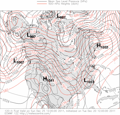
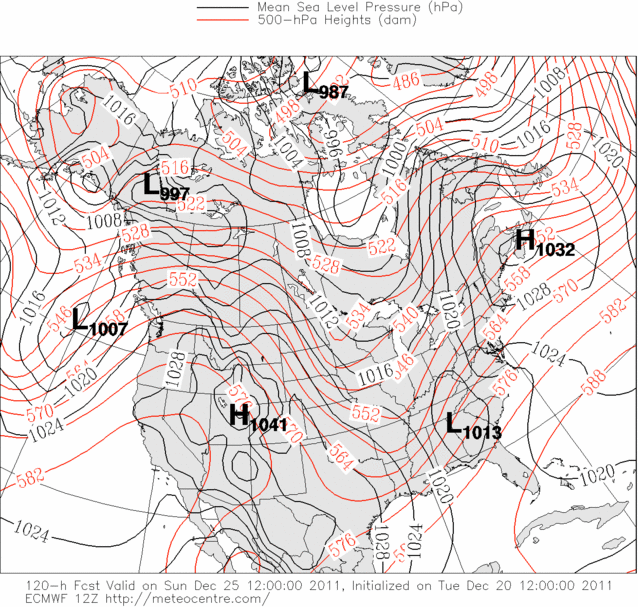
The latest GEM presents a solution on Christmas day that shows precipitation breaking out across the region, especially the central and eastern parts of the state. The location of the low looks favorable for wintry precipitation, but...

The precip type map above shows mostly rain, albeit a cold rain, for the entire region. Now, as the low shifts off to the east and northeast, the colder air will wrap around into the region with any leftover precipitation changing to a period of lt snow or flurries.
The 2m Temperature profile shows why we could expect mostly rain for the region initially...

Temperatures above are presented in Celsius, but you can tell by the color shadings that the nearest blue (or freezing) line would be back in Illinois, moving quickly behind the low that could be traversing the Smokies by this time on Christmas day.
Next up on board is the GFS (12z)
MS
Here's the latest...

The latest GEM presents a solution on Christmas day that shows precipitation breaking out across the region, especially the central and eastern parts of the state. The location of the low looks favorable for wintry precipitation, but...

The precip type map above shows mostly rain, albeit a cold rain, for the entire region. Now, as the low shifts off to the east and northeast, the colder air will wrap around into the region with any leftover precipitation changing to a period of lt snow or flurries.
The 2m Temperature profile shows why we could expect mostly rain for the region initially...

Temperatures above are presented in Celsius, but you can tell by the color shadings that the nearest blue (or freezing) line would be back in Illinois, moving quickly behind the low that could be traversing the Smokies by this time on Christmas day.
Next up on board is the GFS (12z)
MS
Monday, December 19, 2011
White Christmas???
All eyes are glued to the forecast models. There are some indications for a colder period of weather that may finally include the 'S' word by later this week into the holiday weekend. Of course, timing issues will ultimately decide who gets a possible white Christmas.
I've been looking at the GFS Ensembles Mean 2-m level temperatures for the week.
This is for December 25, still several days away so things can change...

A unanimous trend for above normal readings by Christmas day. However, these same ensembles do show below normal readings shortly after December 25. More likely, this appears to be the best time for any significant wintry weather to occur here, according to this most recent run of the ensembles.
Now, let's take a look at the models...
The 0z runs from the Canadian GEM shows this particular setup...

According to the precip type map above, the GEM wants to show a possible mix/ice setup on Christmas morning. Now, that wouldn't be nice.
The GFS shows a slower solution with affected areas more east than the GEM.
This is for the day after Christmas...

The Euro wants to show a nor'easter, where barometric pressure readings drop from 1009mb to 990 mb in 24 hours. This is forecast around Christmas day according to its latest run.
I will be interested in seeing how the 12z runs pan out. Expect many changes both in time and substance as these models try to figure out what may happen.
MS
Sunday, December 18, 2011
Do You Like Science? Wind Chill Calculation

Thanks to the calculation above, it's quite easy to figure out a wind chill reading for temperatures between -45 degrees and 45 degrees Fahrenheit and wind speeds between 3 and 60 mph.
Here's a snapshot of my EXCEL page...
A B C
Temperature(F) | Wind Speed(mph) | Wind Chill(F) |
33 | 18 | 21.88 |
In cell C2, here's the formula as copied from the chart above:
=35.74+0.6215*A2-35.75*(B2^0.16)+0.4275*A2*(B2^0.16)
To use the NWS wind chill calculator, use the formula above or refer to the site below...
Also, review the .pdf format for the Wind Chill Chart that you see above. Something you'll notice on the chart that was not on previous charts is a frostbite indicator with exposure times.
MS
Friday, December 16, 2011
Model Wars - Early Next Week and Pre-Christmas
Well, I decided not to post any graphics for this upcoming storm system early next week. All of the models indicate an all liquid event. But, some residual precipitation may become a mix toward the end of the event according to a couple of models.
Next on board is a storm system that may take shape just before Christmas and the preceding day. By next Friday, the GFS leads the way, again supporting an idea that the teleconnections continue to show, a mild solution with all rain developing from a southern storm system.


Next on board is a storm system that may take shape just before Christmas and the preceding day. By next Friday, the GFS leads the way, again supporting an idea that the teleconnections continue to show, a mild solution with all rain developing from a southern storm system.

Next, the GEM wants to show an all rain event but does support an idea of really cold air filtering in behind this storm system, while tracking eastward and becoming a formidable storm system along the east coast cranking up to deliver possible snows for the eastern part of the state.

The next graphic shows the southern storm now feeding off the Atlantic and produces an east coast storm that could bring accumulating snows to parts of the region as indicated by the precip type map below.

The teleconnection signals continue to favor the GFS in this circumstance. However, the NAO forecast ensembles does show a more negative read by the end of the month. Perhaps by then, the cold air will become established to support a more wintry storm system.
Perhaps, the GEM is trying to pick up on this a little earlier than the GFS. We'll see how the other models try to figure this one out. However, chances for a White Christmas are looking a little less likely. Originally, I had projected a 40% chance for a White Christmas during my winter weather forecast 2011/2012.
MS
Tuesday, December 13, 2011
Model Wars UPDATE 12/13 GEM vs GFS
Yesterday's 0z runs of the GEM and GFS showed two different scenarios for a storm system poised to develop early next week. The GFS showed a progressive solution while the GEM showed a slower solution with a low tracking to our south, providing the region with a possible wintry mix.
Today's 12z runs show the two models combining forces for a slower solution and a storm track to our west. At this time, both are indicating a rain event for the early next week time period. There's just a slight timing difference between the two. The GFS does hint that there could be some wraparound moisture. If cold enough, have to watch for some flakes then.
The 12z ECMWF has also trended northward and westward. Looks like a clean sweep for rain according to the latest trends.
This does correspond with the general atmospheric consensus. NAO to remain positive for the near term.
Just not enough cold air to tap into just yet. However, some of these stronger lows that will be tracking far north of us may bring down chunks of colder air to parts of the U.S. within the next 10-14 days. Perhaps a pattern change then? We'll just have to see.
MS
Monday, December 12, 2011
Model Wars - GFS vs GEM
I found a potential weather system that could be impacting our region by the beginning of next week. In this specific series, I want to follow these two, what I call, medium to long-range model forecasts and their interpretation of the existing data. As an extra bonus, I decided to throw in the ECMWF at the end of this discussion.
A brief introduction is necessary along with the 'cast' that may be playing a role in this potential system.
The maps I'm about to show you are from the GFS and the Canadian GEM-GLB models. Both models are on board that a southern storm system could develop along a strong cold front that may impact our weather here in the next 7 days or so.
Here's the cast of main characters to look for:
1) Cold front in mid-section
2) Developing Low along Texas coast
3) Strong SE ridge of high pressure
First, the GFS model, initialized Sunday evening December 11, for the period of December 20-21


GFS moves the system on outta here with colder air coming in behind the system.


A brief introduction is necessary along with the 'cast' that may be playing a role in this potential system.
The maps I'm about to show you are from the GFS and the Canadian GEM-GLB models. Both models are on board that a southern storm system could develop along a strong cold front that may impact our weather here in the next 7 days or so.
Here's the cast of main characters to look for:
1) Cold front in mid-section
2) Developing Low along Texas coast
3) Strong SE ridge of high pressure
First, the GFS model, initialized Sunday evening December 11, for the period of December 20-21

Primarily a rain event for the area as the SE ridge pumps warm air into the area but shows signs of breaking down and moving on.

Next, the GEM for the same time period initialized at the same time as the GFS.

The SE ridge pumps moisture from the south, creating an all-rain event at the outset. Again, ridge breaks down and moves on...colder air filters in behind the front.

Ah, an ominous southern track that could create wintry problems around here according to this model run. With cold air in place, low rides along the front, creating a potential wintry mess.
Here's a look at precip types according to the GEM for the same time period (Dec 20-21)

Again, all rain along the front...notice a low taking shape down south.

Rain, sleet, and snow setting up, where else, across the battle zone of winter to be or not to be, an all-too familiar scene.
Now, you know these models will change over the coming days. But I posted this so we can see who has the better idea on this system this far out.
Coincidentally, the ECMWF has maps out that go this far out. It too shows a Low from the south, riding up the front that basically slices Kentucky in half, diagonally with rain to the south and southeast and a snow/mix north and northwest.
In another day or so, I'm going to present more models and their thoughts about this potential storm system, including an update on the two that I featured here, the GFS and the GEM.
MS
Sunday, December 11, 2011
Model Wars INTRO
It seems so many weather professionals and enthusiasts rely on the long-term model runs nowadays. You know, I think they're great for giving us an idea about an impending 'large' storm system.
However, and even the professionals will tell you this, so it's not just me, these medium to long-range model runs should not be relied upon to tell you exactly what you're going to get 6-10 days out. Each model run normally adjusts, sometimes wildly, in order to ascertain the best scenario for how the weather will unfold over the coming days. That's normal.
Yet, so many people, often weather enthusiasts like myself, figuratively live and die by each model run of a storm system that hasn't even come into existence.
What I like to do is check out the medium to long-range models and try to take note of any TRENDS, hopefully consistent trends about a particular setup that could lead to significant weather affecting our region. I know that the models are going to flip, waffle, swing, sizzle, and fizzle. That's OK. I expect that to happen because the models are trying to interpret data that is constantly changing. Therefore, I, for one, try not to get too excited about each and every model run from so far out in the future.
But, you may wonder, which of the medium to long-range models are most reliable or most accurate? Good question. I've heard people praise the European model, some the Canadian, and others the GFS. Although each has their strong side, each also has their weak side. Some may be good at showing a future Arctic outbreak but cannot determine how to develop a southern storm system based on energy ejecting out of the southwest. Other models may be able to show a Great Lakes cutter but cannot 'time' a system consistently or accurately.
Well, just for fun, let's try and keep up with some of the more popular medium to long-range models anytime a possible 'big' storm system looms on the horizon and determine which one is best. To be fair, though, I'm going to go out about 6 days so that all of these models will have a chance.
Remember, though, each storm system should be different. I believe that we'll discover some of these models are actually better than others when handling a particular storm system.
Therefore, be looking for it. I'll be posting the first Model Wars soon. I've looked at a few of the models so far, but nothing that important for our weather by next Saturday yet. However, there is a west coast storm to look at and a developing southern storm that is on the grids by then. But, I'm really interested in a possible Pacific storm system that may follow the upcoming one.
MS
Friday, December 9, 2011
Total Lunar Eclipse For the West
Sacramento CA is in line for a nice early morning treat, a total lunar eclipse. The treat is that the eclipse will be toward moonset, when the moon takes on an 'enlarged' appearance, as the atmospheric effects help distort the moon's size.
Colorful hues of copper and orange are expected during the total lunar eclipse.
Next total lunar eclipse on April 15, 2014. We'll be able to see that one, weather permitting.
Read more about the early morning Saturday event here.
MS
Colorful hues of copper and orange are expected during the total lunar eclipse.
Next total lunar eclipse on April 15, 2014. We'll be able to see that one, weather permitting.
Read more about the early morning Saturday event here.
MS
Coldest Air of the Season
The coldest air of the season is on the move. Follow the temps here...

Click on the map above...
Just before 2:00pm, clouds are rapidly increasing throughout north-central Kentucky. Radar echoes of sprinkles/flurries are occurring over parts of central and southern Indiana. Temps are crashing behind the front. Last hour, Indianapolis was at 34 degrees and flurries.
Forecast temperatures overnight suggest teens in areas around Louisville. The city itself has a projected low of 24 but would not be surprised if that value is adjust downward.
MS
Teleconnections - Something To Go By
Several days ago, I noticed a trend from the teleconnectors, NAO, AO, and the PNA that did not favor much in the way of big storm systems producing a hefty snow for our region. So far, these teleconnectors have been right.
What kind of future signals are these teleconnectors pointing to at present?
First, let me share with you today's graphs of the NAO, AO, and the PNA respectively.
North Atlantic Oscillation (NAO)

Please enlarge the graph above, as of today, December 9, the trend for the NAO going forward is positive, with some vascillation between neutral and positive. Although the 7-day forecast confidence level remains quite high, afterward, confidence values decrease. In fact, the 10-day forecast drops below 50 yet continues to show mostly a positive trend.
Not good for big snows around here unless the signals show something different in the coming days.
Next, the Arctic Oscillation (AO)

Unfortunately, the AO is forecast to remain positive, and the forecast values going forward are pretty confident for the next 10 days with some expected fluctuations between positive and neutral.
Last, the Pacific North American (PNA) pattern...

What kind of future signals are these teleconnectors pointing to at present?
First, let me share with you today's graphs of the NAO, AO, and the PNA respectively.
North Atlantic Oscillation (NAO)
Please enlarge the graph above, as of today, December 9, the trend for the NAO going forward is positive, with some vascillation between neutral and positive. Although the 7-day forecast confidence level remains quite high, afterward, confidence values decrease. In fact, the 10-day forecast drops below 50 yet continues to show mostly a positive trend.
Not good for big snows around here unless the signals show something different in the coming days.
Next, the Arctic Oscillation (AO)
Unfortunately, the AO is forecast to remain positive, and the forecast values going forward are pretty confident for the next 10 days with some expected fluctuations between positive and neutral.
Last, the Pacific North American (PNA) pattern...
After a brief dip, the PNA is expected to turn neutral, perhaps slightly positive. PNA values that are negative allow for colder air to stay out west. However, this time, PNA values could go slightly positive in the days ahead. This would warm up the west and provide the midwest some cold air dropping in from Canada. However, as the NAO should remain positive, any cold air should not last too long.
This certainly sounds frustrating, as my winter forecast for 2011/2012 indicates a turn to a long-lasting colder air pattern, especially by the end of the month. Remember, though, it's still early. I'm still expecting the effects of La Nina to begin intensifying here by the end of the month. But, we do need the NAO to begin its trend toward negative, if we are going to see any threat of a big snow system.
Hopefully, in the days ahead, the trend will become our friend and begin pointing toward a colder, more typical wintry pattern for late December.
MS
Wednesday, December 7, 2011
NOWCAST 12/7/11 and Webcams
1:00pm UPDATE
Flakes are mixing in at this time over parts of the state. Look for a transition to all snow by dark or a little after. However, don't expect temperatures to cooperate much for a lot of accumulation.
After dark, accumulations should occur, primarily on grassy surfaces adn again in those areas highlighted yesterday in far e/se Kentucky. I'm still expecting 1-2" in lower elevations and 3-4".
Snowshoe WV

Pikeville KY

MS
Flakes are mixing in at this time over parts of the state. Look for a transition to all snow by dark or a little after. However, don't expect temperatures to cooperate much for a lot of accumulation.
After dark, accumulations should occur, primarily on grassy surfaces adn again in those areas highlighted yesterday in far e/se Kentucky. I'm still expecting 1-2" in lower elevations and 3-4".
Snowshoe WV
Pikeville KY
MS
Tuesday, December 6, 2011
Now Is The Time - NAM 24-36 Hrs Out
It's a good time for me to think about snow amounts for portions of east/se Kentucky. The NAM has been very consistent over the past several runs about a possible snow event.
I want to show you a 850mb map from the NAM for tomorrow (Wednesday morning).


I want to show you a 850mb map from the NAM for tomorrow (Wednesday morning).
Feel free to enlarge the map above by clicking on it. Take note where the zero line is (the solid dark line). For me, it's not so much that the zero line says snow at the surface. I like to see those values around -4 or -6 to see mostly snow at the surface.
Depending on when the precipitation starts, it appears from this run that temperatures above will be warm enough to support mainly rain or a rain/snow mix for the east/southeast during the daylight hours.
However, note what happens by nightfall...
This time, I would like you to click on the map above. Note that the zero line is far east of the region by Wednesday evening. More importantly, notice that temperatures at the 850 mb level will be cold enough to support snow (at least -4). Also, examine that humidity levels will be quite high as indicated by the green shading thus supporting that flakes should still be flying by then in far east and southeast Kentucky.
The latest NAM model run (12z) shows precip breaking out during the morning hours tomorrow. Should be all liquid then. As the day progresses, expect rain transitioning to a mix, and then by nightfall, should become all snow with up to a couple of inches for those areas I highlighted in an earlier post, from Pineville to Pikeville. Most accumulations should be confined to grassy surfaces. However, some slick spots could develop as wet roadways could freeze during the overnight. May even be slushy accumulations in some of the higher elevations on the roadways.
Note the 2 meter temperature profile for overnight late Wednesday/after midnight Thursday, still shows temps near or above freezing. Most precip should be winding down by then.
Therefore, I still think WWAdvisory could go up during the evening and overnight hours for those locations mentioned above as temps could fall below freezing the rest of the night. Really depends on the temperature of the pavement, as well.
Summary:
From Pineville to Pikeville, 1-2", mainly grassy surfaces; up to 3 or 4" in highest elevations of far southeast Kentucky.
Isolated slick spots after dark.
MS
Monday, December 5, 2011
Snow Watch Monday Evening UPDATE
The NAM is still wanting a snow event. The latest 18zNAM continues to paint an accumulating snow for east/southeast Kentucky. Could still be looking at potential 2-4" for most locations of southeast Kentucky.
If the NAM can hold steady on this trend (of a snow event for east/southeast KY), we may be talking about winter weather advisories at the very least. Far east/southeast KY may go under Winter Storm watch as early as tomorrow.
Let's just see how the other models want to negotiate the upcoming storm and see if the leading NAM model will fold or not.
So far, it looks good...
MS
Updated Rain Totals and Flooding Issues
RAIN TOTALS THRU 4:00pm est
Evansville 3.36"
Louisville 2.61"
Paducah 5.02"
Several high water issues around the Commonwealth. Locally, watch out for ponding of water. Poor drainage issues as a result of debris and saturated grounds. Keep those storm drains clear! It does help some.
I'll be talking about possible snows across the state...coming up.
MS
Louisville's All-Time Wettest Year - 2011 (Also Paducah and Evansville)
As of this post, Louisville has just recorded its wettest year ever, exceeding 2004's total of 64.60".
Paducah has also set its all-time wettest year ever, surpassing 1950's total of 70.58" during the morning hours today.
Evansville set its all-time wettest year ever, beating out 2006's total of 66.18" not too long after midnight.
MS
Paducah has also set its all-time wettest year ever, surpassing 1950's total of 70.58" during the morning hours today.
Evansville set its all-time wettest year ever, beating out 2006's total of 66.18" not too long after midnight.
MS
Rain Totals and Snow Watch Update
As of 5:00 am est...
Louisville 1.08"
Evansville 2.40"
Paducah 3.66"
Louisville, your rain is about to become steadier and heavier during rush hour; therefore, take it slow.
Snow Watch continues...
The most recent run of the 06zNAM still shows a decent accumulation of snow for parts of Kentucky. However, the overall focus appears to be centered across east Kentucky, east of I-75. The NAM shifts east a little bit during this run. Let's keep an eye on the trend. Amounts of 2-4" possible, with locally higher amounts by Thr/Fri time frame. Perhaps lt snow/flurries across central Kentucky, up to an inch in places.
GFS trying to compromise, adjusts for possible snow amounts for east Kentucky.
Awaiting the 12zGEM model run early afternoon.
NWS office in Louisville, in its early morning AFD, downplaying snow system, saying SE parts of its county warning area could be clipped...
"The Euro and GFS scoot the upper trough
eastward too quickly, barely clipping our southeast CWA with light
rain Wednesday afternoon/light snow Wednesday night. This latter
solution is the favored result, and really think that most
precipitation will remain southeast of our CWA given the fast
movement of the upper-level shortwave. "
Also, NWS office in Jackson, in its most recent AFD, discusses the possibility of accumulating snow this week...
"ABOUT HALF
OF THE 00Z GFS ENSEMBLE MEMBERS SHOW PRECIP OVER THE FORECAST AREA.
WILL INCLUDE PEAK POPS IN THE CHANCE CATEGORY FOR ALL BUT THE FAR NW
PART OF THE FORECAST AREA WHERE SLIGHT CHANCE WILL BE USED...AND
WILL NEED TO WAIT FOR MORE CONSISTENCY IN THE MODELS TO EITHER RAISE
OR LOWER THE POPS. SHOULD THINGS COME TOGETHER JUST RIGHT...THERE IS
SOME POTENTIAL FOR ACCUMULATING SNOW."
MS
Snow Watch
The snow addict in me is telling me that this could be our first snow of the season of any significance. The latest NAM offered some hope for a burst of snow coming in here behind some really cold air.
One of the analog years that came up is one that I featured in my winter forecast, winter of 2000/01. The analog I saw corresponded with a Jan 2001 setup that put down widespread 2-4" amounts for central and east Kentucky. Some locations had well over 4" during the week.
Although it's still premature to say this is a definite snow setup, I'm getting excited. As I said in a past post, the Dec 7-9 time frame bore watching.
Let's see what the next couple of runs suggest. Pay attention to the NAM. If this is a true snow setup, the NAM will offer the best solution in time.
MS
Sunday, December 4, 2011
Weather Terminology Unmasked
At the NWS office in Louisville, I noticed their overnight Area Forecast Discussion included the term, isentropic lift. Often, I see this term used in their discussions. While I had no idea about an exact definition of the term, isentropic, I knew it was related to precipitation.
First, here's a brief excerpt from the discussion I'm talking about...
"As a weak shortwave ejects from the longwave western trough late
tonight, increasing isentropic lift associated with the rightentrance region of a strengthening jet will bring in a second round
of widespread rain which will overspread our entire forecast area by
the dawn Monday morning."
Thankfully, the NWS provides a glossary for these terms that are underlined. In fact, by clicking on the term, isentropic lift, here is the official definition...
"Lifting of air that is traveling along an upward-sloping isentropic surface.
Isentropic lift often is referred to erroneously as overrunning, but more accurately describes the physical process by which the lifting occurs. Situations involving isentropic lift often are characterized by widespread stratiform clouds and precipitation, but may include elevated convection in the form of embedded thunderstorms."
That's a nice way to explain away the process in general terms. However, isentropic??? Me and my inquiring mind needed to know.
The word itself, isentropic, needed a little bit more explanation. Well, if the term would have been called isoentropic (iso+entropic), I could have figured out a partial explanation. Just as isobars mean lines of equal barometric pressure, isoentropic would mean equal entropy.
And what is entropy? A quantitative measure of disorder, chaos, in a system or process. Sounds a lot like our weather. It's a significant player in the law of thermodynamics that involves heat transfer.
Well, I found an excellent read about the isentropic lifting process HERE.
Here is a partial explanation from the site I just linked you guys to...
"NWS refer to isentropic lift or isentropic upglide simply as the word, "overrunning" in that it is an event defined as relatively warmer, moister air that rides up and over a thin, relatively cooler, drier shallow layer at the surface over a particular region. Such air that is forced to rise upwards when it is moist or when it becomes moist, forces the air to cool and condense into clouds and then water droplets which finally fall as rain, if the isentropic lift is strong enough to bring this about."
However, he describes the process nicely afterward. Give it a read. You might learn something.
MS
Saturday, December 3, 2011
Flood Potential UPDATE
Well, the late evening HPC numbers are in, a little less QPF than previous runs. However, with a solid 2-4" expected statewide, Flood WATCHES are up for much of central and west Kentucky.
The 12zGEM and 18zGFS have pretty much flip-flopped on rain totals since yesterday. Now, the GEM is calling for about 2.07", while the GFS is calling for 1.87" for the period here in Louisville.
Nevertheless, rain totals that approach 2" will cause river levels to rise, possibly nearing flood stage along the Ohio river gauges. If more than 2" occurs, expect minor to moderate flooding throughout the region, including tributaries that flow into the Ohio river.
Personally, I'm expecting about 2.5", good enough to make this the wettest year on record. Even 2" will do it. Man, what a year!
MS
Friday, December 2, 2011
Flooding - A Possibility Next Week
The HPC is going gangbusters here on this early Friday afternoon regarding expected precipitation amounts for next week. 5-day QPF amounts of 3-5" for much of the state is forecast. Sounds a little excessive, but the amounts have trended higher over the past couple of runs. In fact, some in the range of 5-6" downstate could be realized.
The 12zGFS is still showing over 2" for Louisville and the 12zGEM about 1.75". I don't quite have the numbers for the NAM yet, but I don't rely on this model very much for rainfall amounts.
Nevertheless, most models are pointing toward another heavy rain maker, which should lead to river rises that may involve minor to moderate flooding in parts of the state by mid to late next week.
According to the Advanced Hydrologic Prediction Service, the Ohio River LG is forecast to fall slowly to around 40 feet by Monday. With expected heavy rains not yet factored in, expect rapid river rise that looks to exceed flood stage of 55 feet if more than 2" should occur.
The Ohio River UG, where downtown Louisville is located, should fall slowly to a little over 17 feet by Monday. Again, expect the river to rise throughout the week, possibly exceeding flood stage of 23 feet next week if the heavy rains verify.
Stay tuned...
MS
My Forecast Snow Amounts For This Winter 2011/2012
In my winter forecast for 2011/12, I did not include my thoughts about how much snow will fall at any one location for the upcoming winter because, realistically, one cannot know this. There are just too many 'what-ifs' to figure out, and the storm tracks are extremely pivotal in determining who gets a lot and who gets a little or nothing.
But, I have been working on a probability table for some locations with an estimate of how much snow could accumulate for this winter at random locations. Due to timing differences, the snowfall estimates may run over into March.
Louisville:
The heat island effect may play a minor part in our snow amounts at the 'official' location. In my winter forecast, I have Louisville on the edge of heavy snow accumulations. However, I'm still expecting above normal snowfal. I'd rather see snow amounts measured at the National Weather Service on Theiler Lane, away from all of the concrete, though
However, we will stick with the airport readings for this forecast. In order not to bore you with my methodology, I will present only a partial table of probable snow amounts compared to normal.
Dec-Feb Average Snow Amounts = 10.8" (based on 1981-2010 norms)
Probability scale of 1-10 and suggested snow amounts
3 - 14"
4 - 15-16"
5 - 17"
6 - 18-19"
7 - 20-21"
8 - 22-24"
7 - 25-26"
6 - 27"
5 - 28"
Therefore, for Louisville, the highest probabilities of 7 and 8 out of 10 suggest snow amounts in a range of 20-26", probably closer to 22".
----------------------------------------
Lexington:
In my winter forecast, I have Lexington in an area where heavy snow could certainly accumulate. Even if this should not verify, I'm still expecting above normal snowfall.
Dec-Feb Average Snow Amounts = 11.0"
Probability Scale of 1-10 and suggested snow amounts:
4 - 14"
5 - 15-16"
6 - 17-19"
7 - 20-23"
8 - 24-27"
7 - 28-29"
6 - 30"
As you can tell, there is a wide spread in probable amounts, anywhere from 20-29". I think Lexington will be in the middle of that range, 26-27".
In a future post, I'll try and include a couple of other locations. Nevertheless, expect higher snowfall amounts as one travels from west to east across the state.
You can access my thoughts about the upcoming winter on this blog in the Miks Piks section.
MS
How About One More Winter Forecast for Kentucky
This one is from one of my favorite meteorologists in the Louisville area. A multi-year Best of Louisville award winner and everyone's go-to winter weather enthusiast, John Belski.
Click Belski's Winter Forecast 2011/2012
Briefly, he is forecasting 20-25 inches of the white stuff, just slightly below my expectations for the coming winter.
Although I don't believe in forecasting snow amounts so far out, I will be posting the highest probabilities with an estimate of what could accumulate during the Dec-Feb time frame for selected locations.
MS
Thursday, December 1, 2011
Snapshot of December
Average highs really take on a wintertime look.
For Louisville...
Dec 1 - Avg High = 51; Avg Low = 34
Dec 31 - Avg High = 43; Avg Low = 27
From the Climate Prediction Center...
Temperatures:
 Precipitation:

For Louisville...
Dec 1 - Avg High = 51; Avg Low = 34
Dec 31 - Avg High = 43; Avg Low = 27
From the Climate Prediction Center...
Temperatures:
According to the CPC, they are forecasting that the period from December 6-10 will average near normal for temperatures while precipitation is forecast to be above normal.
In addition, for the period from the 8th thru the 14th, above normal temperatures and precipitation are expected.
It could be possible that the CPC is forecasting this scenario based on recent, ongoing teleconnection signals involving the NAO/AO, whose values are expected to be neutral to positive over the coming several days, while the PNA is expected to be negative.
This has been a concern to me, as I noted this trend a few days ago. Serious cold air will be lurking not too far away from our region for the next couple of weeks. In fact, during the first week of December, we should get a taste of what a Polar Pop is like. However, after this period, temperatures are expected to be milder, either supporting all liquid or possible icing, if we get into a shallow layer of Arctic air near the surface while 850mb temperatures may be warm enough to support rain. This would be during the 7-9 period, primarily. Something to keep an eye on.
Personally, I'd rather have the snow. Things always change. Let's hope so.
MS
Tuesday, November 29, 2011
Rainy Days...Sample Cities With Number of Days It Rains
Being in the midst of perhaps our wettest year ever, I wondered how many days has it actually rained, or how many days have we had measurable precipitation of at least 0.01"?
Here's a list up to today, though not including today's totals...
This is day 333 by the way.
Lexington - 135 days
Louisville WFO - 129
Paris - 127
Louisville (Official) - 122
Interestingly, several locations in eastern Kentucky reporting at least 140 days of precipitation exceeding 0.01" include:
Farmers - 162
Beattyville - 156
Inez - 151
W Liberty - 150
Skyline - 147
Flemingsburg - 144
Pikeville - 143
Paintsville - 141
As far as 2011 rainfall totals go, here is an unofficial list to date:
Louisville WFO 67"
Williamsburg 64"
Stearns 63"
Baxter 62"
Louisville (Official) 62"
Morehead 61"
Lexington 61"
Finally, for comparison purposes, here's a look at some U.S. cities with number of days of measurable precipitation of at least 0.01" and their annual total so far...
Seattle, right? Well, yes, but...
Seattle 154 days and only 34"
Hilo, HI 264 days - 77"
Cold Bay AK 232 days but only 33"
Raymond WA 229 days - 76"
Tolt South Fork WA 227 days - 115"
Annette AK 220 days - 102"
Forks WA 219 days - 111"
MS
There Is Snow Nearby...
Yes, it's been snowing nicely in areas south and west of Kentucky, primarily. Accumulations of up to 5" has been reported in parts of Tennessee, Missouri, and Arkansas.
However, even within our region, snow is falling. Evansville and Vincennes among them.
I'm still expecting some snow showers later this evening in Louisville. Not much accumulation is expected. Still, would be a nice scene, though.
Looking at trends several days out, models are trying to 'warm' the next system. The one after that may offer a chance. However, the NAO and the AO ensembles are forecasting positive values and a progressively negative PNA.
That means colder readings out west, milder air comes into the midwest, and the storm track goes west and north of Kentucky toward the Great Lakes. That generally translates to rain instead of snow for us. Hopefully, the models and teleconnection signals will 'cool' off over the next few days.
MS
Monday, November 28, 2011
UPDATE November and Annual Rainfall Totals
For Louisville, here's the latest thru 10:00 a.m.
November - 6.38" (9th wettest November all-time)
2011 Total - 61.57" (3rd wettest year all-time)
Wettest Annual record - 64.60"
---------------------------
For Lexington...thru 10:00 a.m.
November - 6.65" (5th wettest November all-time)
2011 Total - 60.89" (4th wettest year all-time)
Wettest Annual record - 65.76"
---------------------------
Most areas could see another inch before tapering off.
MS
Sunday, November 27, 2011
California Has Just Gotten Smaller
I found this news article from November 21 on NBC. An impressive video account of a nice chunk of real estate sliding into the Pacific ocean near Los Angeles.
http://www.msnbc.msn.com/id/45383284/ns/weather/
MS
http://www.msnbc.msn.com/id/45383284/ns/weather/
MS
Analog Time
This storm system has been a warm breaker, is currently a big rain maker, and will become a cold shaker (on a non-weather related note, metal shakers are better than plastic shakers...). Ok, I digress...back to the weather.
I was trying to find any weather patterns from the past that match up to this storm system's characteristics. Unfortunately, not too many that stand out as this is a slow mover. Plus, it is a GFS analog that I'm using, which did not want to slow this thing down, initially.
However, November 11, 2006 will do. Wasn't a huge rainmaker, but did produce over an inch and a quarter over a couple of days. However, of interest to me, the temperatures went downhill during the next few days. From the mid 50's to low 40's for highs. Even a trace of snow was reported in Louisville during this stretch.
I do anticipate a similar set of temperatures with possible snowshowers during the next few days.
Looking further down the road, I'm still looking at December 2 and 6-7 for possibly a measurable snowfall here in Louisville.
Updates later.
MS
Saturday, November 26, 2011
Another Winter Forecast for Kentucky
Here's another winter forecast for the 2011/2012 season. He really believes that this will be a snowy and cold winter.
Chris Bailey is a down-to-earth weather 'dude'. He tells it like it is and is usually right.
Click HERE for his thoughts.
In the meantime, here is a summary of what he expects...


MS
Chris Bailey is a down-to-earth weather 'dude'. He tells it like it is and is usually right.
Click HERE for his thoughts.
In the meantime, here is a summary of what he expects...
MS
Friday, November 25, 2011
True Confessions of a Snow Addict
Hi, I'm Mike S and I'm a snow addict. They tell me that I've taken the first step, good for me. They understand what I'm going through because they've been there.
But you know what? It's so hard to present the weather in winter without some biased intent or obsessive infatuation with the 'white stuff'. I must say that I've been looking forward to getting plowed by a good ole fashioned snow storm for the past few years.
The last good one I enjoyed was in March 2008, when a surprising 14" collected on my patio tables and chairs here in Valley Station. My little girl was only 6 weeks old; therefore, she doesn't have a clue what a real snow storm is since she slept the entire time I had her in my snow castle.
I do ask for your complete understanding when I start ranting about the 'big one'. I hope to be talking quite a bit about big snows this upcoming winter, but I'll try and tone it down a little at times.
Briefly, it does appear that Louisville could see its first real flakes of the season in a few days. However, I'm looking further down the road at December 2 and 6. We could see our first measurable snowfall during one or both of those time periods. Of course, these dates are approximate but does lend weight to the thought that December will indeed start out nice and wintry.
The models I've been looking at paint below to well below readings for the next 10 days at least, starting this Sunday. In the meantime, enjoy Friday and Saturday if you like pleasant weather. After that, winter's fixins will be on the top of my menu and I can't wait to get a taste of it.
Hey, what can I say? I'm a snow addict and proud of it.
MS
Wednesday, November 23, 2011
Nova Scotia Dealing With 1st Major Winter Storm of Season
The first major snow event in Nova Scotia is causing lots of headaches for drivers, including emergency personnel and salt crews. There are numerous accidents, mostly with minor injuries, but hampering efforts to help clear roadways and getting through to other accident victims.
I'm even hearing reports of a vehicle vs. school bus. Apparently, most students had the day off or were closed for the day due to weather. However, some schools that were open for the day have decided to dismiss early. Hmm, I suppose school districts in Kentucky are not the only ones who make apparent lapses in judgement when it comes to wintry weather.
Parts of Nova Scotia may get up to a foot of snow by tomorrow morning.
Listen in on some of the action HERE
Read about it here
MS
Tuesday, November 22, 2011
Warm Front Pushes Through Louisville...Severe Chances???
During the 11:00am hourly report, the temperature at Louisville International has jumped from the 10:00am observation of 56 to a current reading of 64 degrees. Expect winds to increase steadily throughout the early afternoon hours. Already reports of 35mph gusts at Bowling Green.
Still, quite a few clouds. How will this interfere with severe chances for the region? Currently, low pressure in southern Illinois is racing northeast.
Here's the latest severe outlook from the SPC...

Impressive Storm Relative Helicity values approaching Bowling Green. Based on these values, best chances for severe weather still look to reside south of E'town to Bowling Green and points south from there. Also, east of these locations could see helicity values increasing this afternoon.
Dewpoints in the upper 50's to mid 60's also being reported in parts of west and central Kentucky, supportive of a possible severe setup.
Shear of 40-50kts could possibly aid in a damaging wind potential for parts of the state. I still would not exclude Louisville from the possibility of 45mph winds with an expected squall line that appears to be trying to develop just west of Paducah.
Instability is not impressive; however, the helicity values are still a concern. Could a WATCH be issued? I would say best chances would be south near Bowling Green east to Somerset. E'town east to Richmond. Right now, things just don't look promising, YET. Will be looking for catalysts over the next couple of hours.
MS
Still, quite a few clouds. How will this interfere with severe chances for the region? Currently, low pressure in southern Illinois is racing northeast.
Here's the latest severe outlook from the SPC...
Impressive Storm Relative Helicity values approaching Bowling Green. Based on these values, best chances for severe weather still look to reside south of E'town to Bowling Green and points south from there. Also, east of these locations could see helicity values increasing this afternoon.
Dewpoints in the upper 50's to mid 60's also being reported in parts of west and central Kentucky, supportive of a possible severe setup.
Shear of 40-50kts could possibly aid in a damaging wind potential for parts of the state. I still would not exclude Louisville from the possibility of 45mph winds with an expected squall line that appears to be trying to develop just west of Paducah.
Instability is not impressive; however, the helicity values are still a concern. Could a WATCH be issued? I would say best chances would be south near Bowling Green east to Somerset. E'town east to Richmond. Right now, things just don't look promising, YET. Will be looking for catalysts over the next couple of hours.
MS
Just Another Day in Paradise (Mt Rainier)
Here are some webcam shots at and near the Paradise Jackson visitor center
Snow amounts are really going to add up this week. Continue to check back for more updates on their winter Paradise.
MS
Snow amounts are really going to add up this week. Continue to check back for more updates on their winter Paradise.
MS
Monday, November 21, 2011
***SPECIAL*** Comparing The Winter Forecasts 2011/2012
There's not much time for your predictions about this winter. The beginning of meteorological winter begins December 1 and will end February 29 (leap day). Since this will be a leap year coming forth, I wonder how many professionals factored that extra day into their summaries? Hmm.
For those who are curious about the type of weather one can expect on leap day, here's a couple of locations to think about...
Louisville KY:
Snowiest 2.2" 1912
Deepest Snow Cover 6" 1984
Wettest 0.31" 1952
Warmest Temperature 77 degrees 1972
Coldest Temperature 9 degrees 1884
Lexington KY:
Snowiest 0.5" 1996, 1968
Deepest Snow Cover 3" 1984, 1960
Wettest 0.38" 1908
Warmest Temperature 75 degrees 1972
Coldest Temperature 13 degrees 1960
Statistically, the above figures don't amount to very much. However, we have been in the grips of unusual and extreme weather patterns. I wouldn't be surprised to see a few of the above records for leap day be, well, leapt.
Now, let's talk about the various predictions out there. And believe me, there are a lot of `em,
First, the primary source of our forecasts, which comes from the National Oceanic and Atmospheric Administration (NOAA) and its National Weather Service. Here's what the NOAA page said last month...


Next, one that some people skeptically look at, Farmers' Almanac. However, I think their forecast has a nice ring to it...


Due to the expected track of the storm systems this year, and the NAO for not being as negative as we head into the winter time as well as the AO being more neutral these storms will have a harder time to go as far south as last winter did, thus warm air will mix with the cold air creating the potential for significant ice storms across much of central and eastern Kansas through all of Missouri, northern Arkansas as well as all of Illinois western Kentucky and western and central Tennessee. This is when the storm system will track through Kansas and Missouri. The second storm track when the storms track through the Ohio Valley, typically this is ideal for a warm front to set up across the Carolinas and the Middle Atlantic States with ice storm risk before the warm front moves north changing everything to rain. This winter will be the winter of the Ice Storm over a good deal of the eastern/central United States.
Yet, another one from someone who I've seen on a few blog sites before, Mitch Gaines and his blog site http://mitchg.wordpress.com/
Temperatures


For those who are curious about the type of weather one can expect on leap day, here's a couple of locations to think about...
Louisville KY:
Snowiest 2.2" 1912
Deepest Snow Cover 6" 1984
Wettest 0.31" 1952
Warmest Temperature 77 degrees 1972
Coldest Temperature 9 degrees 1884
Lexington KY:
Snowiest 0.5" 1996, 1968
Deepest Snow Cover 3" 1984, 1960
Wettest 0.38" 1908
Warmest Temperature 75 degrees 1972
Coldest Temperature 13 degrees 1960
Statistically, the above figures don't amount to very much. However, we have been in the grips of unusual and extreme weather patterns. I wouldn't be surprised to see a few of the above records for leap day be, well, leapt.
Now, let's talk about the various predictions out there. And believe me, there are a lot of `em,
First, the primary source of our forecasts, which comes from the National Oceanic and Atmospheric Administration (NOAA) and its National Weather Service. Here's what the NOAA page said last month...


Although, have you seen the latest 3-month forecast from the Climate Prediction Center (Dec-Feb)? Might want to check this out by clicking below...
Here are additional comments from the NOAA discussion...
Another part of the country that typically experiences wetter than average conditions during La Nina winters is the Ohio Valley. As you can see by the outlook map above, this winter is forecast to see above-average precipitation....While La Nina is not a major influence on weather in the Mid-Atlantic and Northeast, the Arctic Oscillation can be a big player. If the combination of enough cold air and moisture come together this winter, we could see above-average snowfall.
Next, one that some people skeptically look at, Farmers' Almanac. However, I think their forecast has a nice ring to it...
Now, let's take a look at another one, who has altered its forecast 3 times now. At least one of them is bound to be right, right? This is from The Weather Centre...


Here's an interesting one from Snow Day...with multiple revisions as well.


Their commentary is as follows...
The second area of much above snowfall will exist from the Ohio Valley through the Great Lakes states and onward through the northeastern United States...I classify above average snowfall at least 5-10" above average and MUCH above average snowfall 10+" above average.
Due to the expected track of the storm systems this year, and the NAO for not being as negative as we head into the winter time as well as the AO being more neutral these storms will have a harder time to go as far south as last winter did, thus warm air will mix with the cold air creating the potential for significant ice storms across much of central and eastern Kansas through all of Missouri, northern Arkansas as well as all of Illinois western Kentucky and western and central Tennessee. This is when the storm system will track through Kansas and Missouri. The second storm track when the storms track through the Ohio Valley, typically this is ideal for a warm front to set up across the Carolinas and the Middle Atlantic States with ice storm risk before the warm front moves north changing everything to rain. This winter will be the winter of the Ice Storm over a good deal of the eastern/central United States.
Yet, another one from someone who I've seen on a few blog sites before, Mitch Gaines and his blog site http://mitchg.wordpress.com/
Temperatures

Precipitation
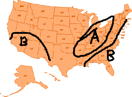
Snowfall

Well, in addition to the ones I've presented here, we in the community have our local weather heroes, who perform an outstanding service for our areas. They have even offered their insights into the winter of 2011/2012. Check them out at their respective blogs and facebook sites.
Also, don't forget to check out my official winter weather forecast by looking at the right hand side of my blog entitled MY 2011/2012 WINTER FORECAST
MS
Sunday, November 20, 2011
A Winter Paradise
In Washington state, not too far from the summit of Mt Rainier, at an elevation of nearly 5,500 feet is an area called Paradise. At the Ranger Station in Paradise, some of the heaviest snow amounts are recorded here on an annual basis, over 600" worth.
The snow season (for everybody) begins July 1 and ends June 30 each year. So far, since July, the Ranger Station has recorded 'just' 76.1". Of that total, 72" has occurred this month.
However, last year, snow amounts were more robust. In October 2010, 60.2" was recorded and 175" in November. In fact, last season's annual snow amounts from July 1 2010 to June 30 2011 amounted to a whopping 921"! A winter lover's paradise indeed.
Ironically, Paradise was not named for its winter pleasure but its beautiful views of Mt Rainier and the meadows of wildflowers.
Here's a quote from the National Park Service..."Paradise is famous for its glorious views and wildflower meadows. When James Longmire's daughter-in-law, Martha, first saw this site, she exclaimed, "Oh, what a paradise!"

A storm system along the west coast is expected to stall and produce copious amounts of precipitation, especially in Washington. Snow, very heavy at times, is expected above the 5,000 foot level, including the Ranger Station at Paradise.
Here's a breakdown of the current forecast this week...
Tonight: Snow, mainly after 4am. Low around 19. West wind between 5 and 7 mph. Chance of precipitation is 80%. New snow accumulation of 1 to 3 inches possible.
Monday: Snow showers. High near 27. West wind between 5 and 9 mph. Chance of precipitation is 90%. New snow accumulation of 4 to 8 inches possible.
Monday Night: Snow. Low around 25. West southwest wind around 10 mph. Chance of precipitation is 90%. New snow accumulation of 10 to 14 inches possible.
Tuesday: Rain. Snow level 5300 feet. High near 33. Southwest wind between 8 and 14 mph. Chance of precipitation is 100%.
Tuesday Night: Snow. Low around 28. Chance of precipitation is 100%. New snow accumulation of 8 to 12 inches possible.
In addition, snow is expected every day through Saturday. This should help out the snow 'deficit' that's been ongoing for the past couple of months.
MS
The snow season (for everybody) begins July 1 and ends June 30 each year. So far, since July, the Ranger Station has recorded 'just' 76.1". Of that total, 72" has occurred this month.
However, last year, snow amounts were more robust. In October 2010, 60.2" was recorded and 175" in November. In fact, last season's annual snow amounts from July 1 2010 to June 30 2011 amounted to a whopping 921"! A winter lover's paradise indeed.
Ironically, Paradise was not named for its winter pleasure but its beautiful views of Mt Rainier and the meadows of wildflowers.
Here's a quote from the National Park Service..."Paradise is famous for its glorious views and wildflower meadows. When James Longmire's daughter-in-law, Martha, first saw this site, she exclaimed, "Oh, what a paradise!"
A storm system along the west coast is expected to stall and produce copious amounts of precipitation, especially in Washington. Snow, very heavy at times, is expected above the 5,000 foot level, including the Ranger Station at Paradise.
Here's a breakdown of the current forecast this week...
Tonight: Snow, mainly after 4am. Low around 19. West wind between 5 and 7 mph. Chance of precipitation is 80%. New snow accumulation of 1 to 3 inches possible.
Monday: Snow showers. High near 27. West wind between 5 and 9 mph. Chance of precipitation is 90%. New snow accumulation of 4 to 8 inches possible.
Monday Night: Snow. Low around 25. West southwest wind around 10 mph. Chance of precipitation is 90%. New snow accumulation of 10 to 14 inches possible.
Tuesday: Rain. Snow level 5300 feet. High near 33. Southwest wind between 8 and 14 mph. Chance of precipitation is 100%.
Tuesday Night: Snow. Low around 28. Chance of precipitation is 100%. New snow accumulation of 8 to 12 inches possible.
In addition, snow is expected every day through Saturday. This should help out the snow 'deficit' that's been ongoing for the past couple of months.
MS
Subscribe to:
Posts (Atom)
-
Recently, I noticed that our days have now begun to shorten. However, our sunset here in Louisville still remains at 9:10pm edt. Starting th...
-
 In July of this year, I did a segment about the latest sunsets in the eastern time zone. This corresponded nicely with the summer solstice a...
 -
A 1 Temperature C Humidity F Heat Index 2 81 82 86.82 This is an Excel spreadsheet program. Fairly ...
