What a comeback! After nearly 2 weeks of Fall-like temperatures earlier this month, the longest stretch of 90 degree heat ends today in Louisville. Eight consecutive days in the 90's beat out the previous streak of 7 in July. In addition, the entire state's average temperatures increased. What was once expected to be an impressive below normal month now shows several reporting stations (at least NWS offices) going to be near normal or even above normal.
Here is a look at the NWS offices in Kentucky and their temperature departure from average as of this morning, the 28th...
Louisville..........+0.3
Lexington..........+0.1
Bowling Green...-0.5
Frankfort............+0.6
Jackson...............-0.2
London...............-1.2
Paducah.............+1.7
However, we have transitioned again to our Fall-like pattern, but maybe only for a few days. Yet, it may be enough to help offset these averages just a bit for the rest of this month.
So, what did I come up?
Projection time....
My information is taken from the F-6 form at weather.gov, a preliminary form of the monthly climatic data. If you look just below the last calendar day entry, on the left hand side, you will note a sum (SM) with a couple sets of 4 digit numbers like this...
SM 2216 1646
This represents the sum of the high temperatures from the one column and the sum of the low temperatures from the next column.
I total these together.
Next, find the average temperature for the month then multiply by 30 days and multiply again by 2 for another total sum.
Now, compare the total sum for 'average' with the current total sum in the sample above.
Subtract the current sum from the monthly 'average' sum.
Look at the area forecast for the rest of the month and add the forecast high and low temperatures through midnight of the last day of the month.
How does this compare with the 'average'? Is it higher? Lower?
Sounds complicated, but not really.
Let me walk you through Louisville's F-6 sheet...
SM 2211 1669......Current Sum = 3880
Average temperature for September is 71.0 degrees (found on another page)
Multiply 71.0 by 30 days = 2130
Multiply by 2 (for combining high and low)
Average September Total Sum = 4260
Subtract Current Sum from 'Average' Sum = 380
Expected Forecast temperatures total...
low temp from this morning = est. 60
high temp 28th = 75
low temp 29th = 53
high temp 29th = 76
low temp 30th = 51
high temp 30th = 71
Add those numbers to get 386
This number is greater than the 380 just to reach normal
Therefore, the forecast or projection is for a total of 3880+386=4266
Divide 4266/30 days to get combined high/low 142.2
Divide by 2 to get overall average of 71.1
71.1 is greater than the 'average' for September of 71.0
Therefore, projection is Louisville to finish the month 0.1 degrees above normal
Lexington should finish at normal or 0.1 degrees above normal depending on how they round the numbers.
Jackson looks to finish right at normal, even slightly above but not enough for rounding up.
Frankfort and Paducah should finish above normal.
Bowling Green and London should finish the month below normal
There you go. Only 2 out of the 7 forecast centers that I follow are projected to be below normal. Oh, by the way, the Louisville Bowman Field area, the WFO, the one with less concrete than the official site, may actually finish at least 0.3 degrees above normal, kind of surprising compared to the official site.
MS
Friday, September 29, 2017
Monday, September 25, 2017
MikJournal Monday 09/25/2017...Review of Summer
I hope your Monday is off to a good start. Before I get into some of the details of this summer past, how about this stretch of summer? Here in Louisville, we have recorded 5 consecutive days in the 90's. That has now raised our September average temperature to a modest 1.3 degrees below normal. Lexington is only 1.2 degrees below normal. And we still have at least 3 more days of above normal readings to go before we begin transitioning to more seasonal levels.
Dare I say I might be making projections for the temperatures of September? This should have been a slam dunk for below normal temperatures this month, after the 2 weeks of 'ahhh' weather we enjoyed earlier this month. But now...?
It's going to be that close. Quite likely, I will be making a midweek post with projections about whether we will be below, at, or above normal for the month.
Just a preliminary look, and again, this is not my official projection yet, but this could be how it plays out for the rest of the month...
Remember, all of this could change, because there is a cold core of air that will be positioned just to our west, but it seems that the NWS Louisville is not taking this into consideration yet.
Looking at a normal month in Louisville of 71.0 degrees for the entire month of September, we would need a total (high and low combined) of 4,260 degrees. Right now, we have achieved a total of 3,404 degrees, leaving us with a total combined high and low temperature of 856 degrees to go for the rest of the month just to achieve normalcy.
The official forecast for Standiford Field is for a total of 858 degrees, which by definition would make it an above normal month. However, once all of the averages are taken into consideration and subsequent rounding, it may just become a normal month.
Following the same pattern but for Lexington, I achieved a similar result, an above normal month by definition, but after averaging and rounding, just a normal month.
So, that will be interesting to see how it unfolds.
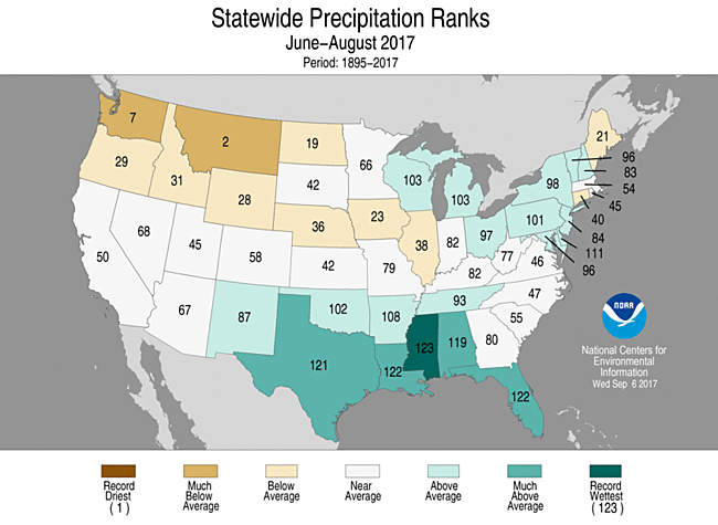
Now, a review of this past summer. Regionally, I already kind of hashed the numbers out in an earlier post. But, most of the region saw a below normal summer for June-August. Nationally, how did we do?
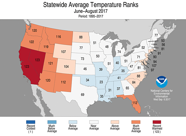
While Kentucky was accompanied by several states of the mid and deep south for a below normal summer, Nevada and California saw their warmest summer on record. Oregon almost achieved their warmest summer.
Montana had its 2nd driest summer on record and is in the grips of an impressive drought. Mississippi had its wettest summer ever, while Florida and Louisiana had their 2nd wettest summer on record.
In fact, Naples in Florida has already seen its wettest year on record, and that is with incomplete data from earlier this month.
Globally, could the string of year after year warmest land and sea temperatures be coming to an end? It's possible. Projections (not mine this time) are for 2017 to be the 3rd warmest on record when combining the land and ocean surface temperatures.
So, keep an eye for that midweek post. Hopefully, I'll have updated information whether there will be a more pronounced cooling trend coming up or not.
Otherwise, make it a good week.
MS
Dare I say I might be making projections for the temperatures of September? This should have been a slam dunk for below normal temperatures this month, after the 2 weeks of 'ahhh' weather we enjoyed earlier this month. But now...?
It's going to be that close. Quite likely, I will be making a midweek post with projections about whether we will be below, at, or above normal for the month.
Just a preliminary look, and again, this is not my official projection yet, but this could be how it plays out for the rest of the month...
Remember, all of this could change, because there is a cold core of air that will be positioned just to our west, but it seems that the NWS Louisville is not taking this into consideration yet.
Looking at a normal month in Louisville of 71.0 degrees for the entire month of September, we would need a total (high and low combined) of 4,260 degrees. Right now, we have achieved a total of 3,404 degrees, leaving us with a total combined high and low temperature of 856 degrees to go for the rest of the month just to achieve normalcy.
The official forecast for Standiford Field is for a total of 858 degrees, which by definition would make it an above normal month. However, once all of the averages are taken into consideration and subsequent rounding, it may just become a normal month.
Following the same pattern but for Lexington, I achieved a similar result, an above normal month by definition, but after averaging and rounding, just a normal month.
So, that will be interesting to see how it unfolds.
Now, a review of this past summer. Regionally, I already kind of hashed the numbers out in an earlier post. But, most of the region saw a below normal summer for June-August. Nationally, how did we do?
While Kentucky was accompanied by several states of the mid and deep south for a below normal summer, Nevada and California saw their warmest summer on record. Oregon almost achieved their warmest summer.
Montana had its 2nd driest summer on record and is in the grips of an impressive drought. Mississippi had its wettest summer ever, while Florida and Louisiana had their 2nd wettest summer on record.
In fact, Naples in Florida has already seen its wettest year on record, and that is with incomplete data from earlier this month.
Globally, could the string of year after year warmest land and sea temperatures be coming to an end? It's possible. Projections (not mine this time) are for 2017 to be the 3rd warmest on record when combining the land and ocean surface temperatures.
So, keep an eye for that midweek post. Hopefully, I'll have updated information whether there will be a more pronounced cooling trend coming up or not.
Otherwise, make it a good week.
MS
Monday, September 18, 2017
MikJournal Monday 09/18/2017...Remembering Hurricane Hugo and Maria Looming
Welcome to another installment of MikJournal Monday. It looks like a pretty quiet week in terms of weather. Yes, there will be a few showers out there from time to time, not a complete washout. Temperatures are going to be warm, very warm as the averages try to come up from several days of below average readings this month.
In fact, 13 of the first 14 days of the month saw below normal temperatures here in Louisville. However, it appears we will have several days this week of temperatures near or above normal, depending on cloud coverage. Then later this week, possibly later in the weekend, we will begin transitioning to more fall-like temperatures.
So, with our weather nice and warm, I wanted to talk hurricanes for this segment. On this day in 1989, Puerto Rico was ravaged by Hurricane Hugo as landfall occurred near the town of Fajardo on the main island. The San Juan airport registered wind gusts of over 90 mph and the old Roosevelt Roads Naval Station had a 120 mph gust.
Of course later on, Hugo would make its trek through the Bahamas and set its sights along the Southeast coast, eventually making a significant, impactful landfall near Charleston, SC at Sullivan's Island as a Cat 4 hurricane.
As a side note, the Hurricane Hunters had what was called the 'Hairy Hop' as the initial plane, nicknamed 'Kermit', went to fly into the eyewall at about 1,500 feet, and got a little more than they were expecting. Normally, they would fly at an altitude of 5,000 to 10,000 feet but were anticipating a weak hurricane.
Well, the hairy hop occurred when they encountered severe turbulence that put the mission, and for that matter, the lives of the 16 aboard, in jeopardy. Ironically, prior to takeoff, one of the reporters had asked, "Where are the parachutes?", the response was that parachutes would be of no value where they were going.
Severe turbulence? You be the judge. An updraft/downdraft/updraft triplet of 20 mph, 22 mph, and 45 mph respectively and horizontal winds of 185 mph violently shook the plane, causing even secured items to become loose in the cabin such as a 200-pound life raft, and caused a fire in one of the four engines. Worthy of a Hollywood blockbuster film, the pilots have to take measures to erase a 620 foot plunge of a few seconds that keeps them some 880 feet above the ocean waters. Crippled, the plane still has to be navigated to find a way out...
More information, including a story from the lead flight commander, can be obtained from sites below...
the hairy hop
Hunting Hugo...as told by Dr. Jeff Masters
I like a good cliff-hanger, or in this case, a hurricane hanger.
I mention Hugo, because another hurricane is about to hit the island of Puerto Rico. Meet Maria. If that happens, where will it go afterward? Could it take a similar trek as Hugo and head for the east coast?
A fairly reliable forecast model has the trek staying out to sea once it emerges from near the Bahamas. In fact, it may even stay a bit more east of Jose's track. But, remember, Irma's direction could not be accurately predicted until just hours before landfall. The models just could not figure out the periphery of the sub-tropical ridge.
The strength or weakness of that ridge will play a huge role in where Maria will go, and determine how close any impacts will be realized along the east coast. At the very least, waves and rip currents will continue to be a problem for the rest of the week and into the weekend.
Make it a great week.
MS
Thursday, September 14, 2017
MikJournal Midweek Post 09/14/2017...Rainfall Amounts and Geography Trivia
As promised, I am posting a midweek update for rainfall totals and some geography trivia that might ruffle some feathers. So, please provide any other suggestions I can use to help answer the trivia question. More on that in a moment.
In Jefferson County, I have seen rainfall amounts range from 0.38" to 1.10" since September 11, or this past Monday. Here at my house, I saw 0.56", bringing my monthly rainfall total to 5.22". The airport at Louisville International has also recorded 0.56" through noon today.
However, since the state continues to see showers today, I will not be updating the totals on the side of the blog until the weekend.
Next up is Jose. The Euro has Jose weakening but tracking farther westward than some residents' comfort level allows. Although no landfall is forecast for the U.S., the center may approach close enough to throw some wind and rain toward Cape Cod, Martha's Vineyard, and Nantucket Island. However, wave action will be quite noticeable. Rip currents are expected to be a problem. It will be a storm system that the Northeast residents will want to watch pending any additional westward shift.
Now, for your geography trivia, which might prove controversial...
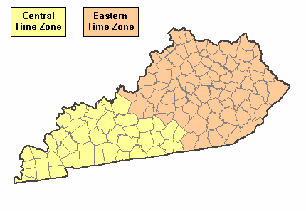
A two-part trivia question for you. Based on the map, what is the westernmost point of the Eastern Time Zone in Kentucky? What is the easternmost point of the Central Time Zone?
I invite your input. I have looked at my Kentucky map and found Meade County to be the westernmost point of the Eastern Time Zone and Russell County as the easternmost point of the Central Time Zone.
But, this is where it could become quite controversial. Now, when I ask where, hopefully you understand I am not looking for a physical location, like a boat dock ramp or a highway mile marker or even a county line sign. I am not even asking for someone's property like Old Man Williams' scarecrow in the back of his cornfield (name is fictitious, if name is Williams, sorry about that). I am talking about a community or town which has a legitimate, verifiable post office and zip code.
I came up with Concordia in western Meade County though there are a couple of others that could be acceptable. Then, I came up with Vinnie near the Russell/Pulaski county line.
I find time zones and daylight/standard time interesting. Did you know our Eastern Daylight Time is the same as Atlantic Standard Time? A few northeastern states have been mulling over whether to switch to Atlantic Standard Time instead of fooling with the switch twice a year. I guess some people don't like to lose that extra hour of sleep during the initial Spring switch or show up one hour late to Church during the initial Fall switch.
We'll talk again...
MS
In Jefferson County, I have seen rainfall amounts range from 0.38" to 1.10" since September 11, or this past Monday. Here at my house, I saw 0.56", bringing my monthly rainfall total to 5.22". The airport at Louisville International has also recorded 0.56" through noon today.
However, since the state continues to see showers today, I will not be updating the totals on the side of the blog until the weekend.
Next up is Jose. The Euro has Jose weakening but tracking farther westward than some residents' comfort level allows. Although no landfall is forecast for the U.S., the center may approach close enough to throw some wind and rain toward Cape Cod, Martha's Vineyard, and Nantucket Island. However, wave action will be quite noticeable. Rip currents are expected to be a problem. It will be a storm system that the Northeast residents will want to watch pending any additional westward shift.
Now, for your geography trivia, which might prove controversial...
A two-part trivia question for you. Based on the map, what is the westernmost point of the Eastern Time Zone in Kentucky? What is the easternmost point of the Central Time Zone?
I invite your input. I have looked at my Kentucky map and found Meade County to be the westernmost point of the Eastern Time Zone and Russell County as the easternmost point of the Central Time Zone.
But, this is where it could become quite controversial. Now, when I ask where, hopefully you understand I am not looking for a physical location, like a boat dock ramp or a highway mile marker or even a county line sign. I am not even asking for someone's property like Old Man Williams' scarecrow in the back of his cornfield (name is fictitious, if name is Williams, sorry about that). I am talking about a community or town which has a legitimate, verifiable post office and zip code.
I came up with Concordia in western Meade County though there are a couple of others that could be acceptable. Then, I came up with Vinnie near the Russell/Pulaski county line.
I find time zones and daylight/standard time interesting. Did you know our Eastern Daylight Time is the same as Atlantic Standard Time? A few northeastern states have been mulling over whether to switch to Atlantic Standard Time instead of fooling with the switch twice a year. I guess some people don't like to lose that extra hour of sleep during the initial Spring switch or show up one hour late to Church during the initial Fall switch.
We'll talk again...
MS
Monday, September 11, 2017
MikJournal Monday 09/11/2017...Irma's Fury and Regional Impact
Good Monday to ya! Clouds are beginning to stream into our region from Irma, now blasting southern Georgia after pummeling the state of Florida.
The hurricane may not have been as intense as expected, but its widespread effects were felt statewide across Florida, and its effects will be felt throughout most of Georgia into Alabama and Tennessee.
And yes, we will feel the effects here, but it should not be as bad as Harvey's remnants. A general 1-1.50"(WPC) could be realized throughout the week along with some gusty winds and cool temperatures, at least through midweek.
Irma's fury was realized across Florida yesterday. Some notable highlights were a 142 mph wind gust at Naples, an apparent vortex or spin-up in the background as Mike Bettis of The Weather Channel was reporting live footage about the hurricane, the millions of residents who have no power statewide, and now that daylight has arrived, the damage left behind.
We are still awaiting word on how our relatives and friends have fared during this frightful ordeal.
Some of the local storm reports coming out of central Florida this morning were water rescues in West Orange county, hurricane wind gusts of 75-80 mph at Orlando, significant flooding along Beach Rd in Daytona, additional wind gusts of 65-70 mph just north of Orlando in Leesburg and Sanford.
I have been following live coverage on WESH 2 about the severe flooding in Orlo Vista.
Also, the relentless rainfall was noted in this climatological report for Sunday...
Daytona Beach: 4.10 inches; Daily record
Fort Pierce: 13.08 inches; Daily and ALL TIME record (since 1901)
Melbourne: 10.23 in; Daily and ALL TIME record (since 1937)
Orlando: 6.61 in; Daily record
Sanford: 9.24 in; Daily and ALL TIME record (since 1948)
Across South Florida, several of the weather offices have missing data for yesterday, such as precipitation amounts and highest wind speeds. Hopefully, all of the data will eventually be made available soon. But, video footage shows much tree damage and other property damage.
I am checking in on live coverage on NBC 6 out of Miami, listening to the damage assessments coming in, watching drone footage of the damage in Naples, wind and flooding. Even saw a video of Kristen Bell, voice of Princess Anna in the movie 'Frozen', paying a surprise visit to a shelter at a middle school, helping comfort the little ones there.
Even before Irma's visit, Naples recorded its wettest summer of all time, records dating back to 1942, with 41.42". That would compare to a little over 20" maximum amounts here in Kentucky.
Speaking of Kentucky, heavy rainfall from the 2nd tropical system this month is poised to move into the region, possibly soaking areas that received over a half foot of rain earlier this month. However, it has been emphasized that the rainfall from Irma does not appear it will match the amounts we saw from Harvey.
I will have a midweek post that will include any rainfall amounts locally and any wind gusts associated with the remnants of Irma. Also, you know that Kentucky has two time zones in the state, central and eastern. But do you know the westernmost point of the eastern time zone in the state? How about the easternmost point of the central time zone? Check back with suggested answers in your geography trivia for the week.
Have a good one.
MS
Monday, September 4, 2017
MikJournal Monday 09/04/2017...Summer Recap and Harvey_Irma
Welcome to the first Monday of Meteorological Autumn. Yep, it's hard to believe, but summer is officially over...well, after today according to some pundits.
Summer really fizzled out there at the end. Oh yeah, we had some hot summer days here at my place and in the 'heat island capital of the country' at Louisville International airport. But, August went down in the books as a below normal month for temperatures, first time having a below normal month since May 2016 according to the NWS Louisville.
In addition, most of the region had a below normal summer. Bowling Green, Lexington, Frankfort, and even Louisville, well, most of Louisville, ahem...sorry, I had to clear my throat. Although the NWS Louisville modestly calculated the official summer as normal (or 0 degrees average), my calculations say they barely eked out an above normal summer...
June...+0.3
July...+1.4
Aug...-1.5
Boys and girls, that leaves us with a balance of +0.2. Now, divide that by the 3 months of summer and we get an average of +0.0666. Now, when I was in school, I was taught to round up if the number was a 5 or higher. Well, that 0 in the tenths place needs to be rounded up because the 6 in the hundredths place says so, according to the rules. Therefore, that gives us a total average of +0.1 degrees.
I rant about this, because it is what it is, another concrete-aided, above normal summer. Yet, you travel right down the road at Bowman Field, another airport with a lot less 'crete and more grass, and you have a below normal summer, rather decisively I might add. Personally, I believe the NWS office is trying to downplay the obvious or glaring difference that everyone else was below normal while officially Louisville was above normal. I've said it before, the official location is a poor representation from a climatological standpoint and needs to change.
Moving on finally. Regional rainfall totals are in from the leftovers of Harvey, and they are impressive. Nearly 9" fell during the 3-day period from August 31 through September 2 at the Mesonet site in Barren County not far from Glasgow. Why, even at my house 10 miles southwest of Louisville International airport, I collected 4.46".
Speaking of rainfall measurements, I have been collecting rainfall for both of my rain gauges. I have a 5" Acurite manual rain gauge and a homemade rain gauge that is comprised of a Barilla spaghetti jar and a funnel the exact size of the opening diameter. I have been complaining about the Acurite rain gauge being inaccurate for some time now. But, an interesting thing happened....
Well, both of the gauges were nearing full capacity, unchartered territory for both gauges. In fact, my homemade rain gauge's funnel had rainwater standing halfway up the funnel. I think I still had room for another half inch before overflow. So, I collected 4.46" in that gauge. Then, I measured the Acurite gauge, expecting overflow. Surprisingly, it was under 4.50". In fact, it registered a little bit less than my homemade rain gauge, at 4.40".
After this evidence, I am becoming more convinced that the Acurite rain gauge really can measure 5" of rainfall; however, the demarcation lines leading up to the 5" mark are not as accurate as they should be. At times, I believe that some measurements may be more than 0.25" off.
Now, looking ahead. I have looked at the latest GFS and Euro runs for Hurricane Irma. There is still uncertainty about where this beast is heading. At 7-8 days out, the Euro has Irma nearing the southern coast of Florida turning northerly parallel to the coast and making landfall in the Carolinas.
The GFS has a more southerly track with landfall in Florida and moving northward through Georgia.
I don't much stock into the GFS. But, it does warrant attention, since it has Irma paying a visit to Kentucky and parking it here with more insane tropical rainfall amounts for our region.
The Euro has Irma affecting parts of our region, though the low pressure center looks to stay east of the Appalachians. Still, it appears moisture will be driven westward, affecting primarily central and eastern parts of the state.
Again, it is a long ways out. But, I'm sure we will be glued to our Tv's, anticipating the next run from the models, perhaps even making Vegas-style wagers about where and if this thing will make landfall.
Just stay tuned. We are at least a week away from any effects that may impact the region.
Meanwhile, here is your state and territory weather extremes for the week....
September 4...
1979 - Annas Hope, Virgin Islands (U.S.)...20" (24-hr Precip Record)
September 4-5...
1970 - Workman Creek, AZ...11.4" (24-hr state precip. record)
September 6...
1925 - Centreville, AL...112 degrees (state high temp record)
Make it a great day and rest of the week.
MS
Subscribe to:
Posts (Atom)
-
Recently, I noticed that our days have now begun to shorten. However, our sunset here in Louisville still remains at 9:10pm edt. Starting th...
-
 In July of this year, I did a segment about the latest sunsets in the eastern time zone. This corresponded nicely with the summer solstice a...
 -
A 1 Temperature C Humidity F Heat Index 2 81 82 86.82 This is an Excel spreadsheet program. Fairly ...
