Well, April 2011 will go down in the record books as one of the most violent and wet months of all time, not only for the state of Kentucky, but throughout many areas primarily east of the Mississippi river.
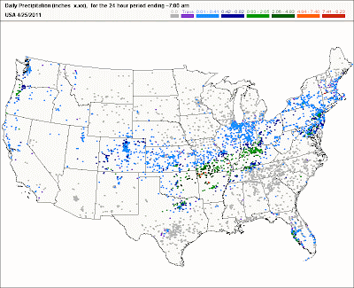
First, the obvious here in Kentucky. Record rains for the month were set in places like Frankfort, Lexington, and Louisville. How do these amounts compare to the all-time wettest months ever? Here's a breakdown.
As of 04/29:
Louisville (C) 13.97"
Louisville (R) 5th
Lexington (C) 12.70"
Lexington (R) 4th
Frankfort (C) 13.95"
Frankfort (R) 2nd
* (C) current month; (R) all-time wettest month ranking
For the year, Louisville has recorded 26.31". Last year about this time, we had collected 9.91"
Next, the flooding along the Ohio river reached levels not seen since 1997. McAlpine LG readings exceeded 62 ft while the UG readings exceeded 32ft. However, while our flooding still did not reach record levels, some places in the western part of Kentucky have indeed set all-time levels.
At one point, some 90 roads were closed due to high water in Henderson county. Paducah and Smithland recorded record flooding levels, and they may not see levels below flood stage for quite a while.
Finally, let's don't forget that it's been a violent month of severe weather. For the last several days, I've been paying special attention to the number of confirmed tornadoes in the state. The all-time record for confirmed tornadoes in any month for Kentucky is 29, in 1974 (the most recent). While storm survey analyses are continuing, the latest figures are somewhere in the low 20's range. Those numbers may go higher once the NWS surveys are officially completed.
What I found interesting about the confirmed tornado counts is that in several locations, only wind damage was intially reported. But, in reality, tornadoes caused much of those damages, however brief the touchdowns may have been.
More updates later...
MS
Friday, April 29, 2011
Thursday, April 28, 2011
Storm UPDATES from AL, MS, GA
Here is the latest...
6:25pm
I saw this quote, "You cannot prepare against an F5," the most powerful category on a scale for measuring wind intensity, Bentley(Governor) said.
Remember, the Fujita Scale does not seek to measure wind intensity. The scale is used to assess damage to structures and other objects. Wind speeds are estimates only. If you want wind intensity, use a Beaufort Scale; the Fujita Scale is only used for tornadoes and the damage caused by estimated wind gusts.
More on this in a future post...
6:15pm
Death toll in Alabama alone now at 194. Incredible!
2:35pm
Alabama Power reports that 337,000 customers still without power
Alabama death toll, as of this post, is up to 162
NWS has 3 survey teams in Alabama to conduct and assess tornado damage
Mississippi death toll at 32
Georgia death toll at 13
Virginia - at least 8
Tennessee - 32
Kentucky - 1
Chattanooga still has 80,000 without power
5:05pm
Total death toll up to 271
MS
5:05pm
Total death toll up to 271
The Day After...
After one of the deadliest tornado outbreaks ever recorded in the U.S., today will be a grim day for assessing the damage, finding ways to clean up, salvaging any personal belongings, and, unfortunately, uncovering more bodies.
The death toll continues to escalate as more bodies are being pulled from the rubble. As of this post, at least 215 people are now confirmed dead across some 6 states.
While hearing reports of some mindless individuals taking advantage of the situation by looting victims' belongings, I'm hearing more reports of how people risked their necks to find their neighbors, helping the badly injured by putting together makeshift stretchers from strewn debris, and courageously dealing with the aftermath of something that, for them, has not really sunk in yet.
Today, I hope to find some good news from the rescue and cleanup efforts to report on, share some of my favorite pics and videos, and share tornado damage information that survey crews will be assessing for today, if they can even get into some of these areas.
MS
Wednesday, April 27, 2011
The Grand Finale...w/UPDATES
The last in a series of drenching and damaging storms coming our way, setting up a scenario that will place this long-lived storm system in the record books. And speaking of records, Louisville has easily surpassed its all-time April rainfall record with nearly 2.25" falling since midnight as of 5:00am report. Now, that Louisville has surpassed its all-time April record, that places us in the top 10 wettest months of all time.
At 12.88", we are now ranked 6th on that list. Looks like we'll easily move into 5th in just a little while. More updates on that later.
Follow my updates on river levels, flooding, and severe storm chances for this storm system's grand exit today.
7:40pm
Like you, I've been glued to TWC watching just a horrific scene; almost surreal, like I was watching a sequel to the blockbuster movie "Twister". Debris ball signatures on radar, watching debris fall from the sky of a tornado that hit 17 miles away in nearby Tuscaloosa. Just horrible. Damage has been classified as "extreme".
On a lighter note, The Great Steamboat Race postponed due to high water on the Ohio.
6:12pm
Tuscaloosa - Tornado emergency; debris ball just west of University of Alabama; damage more than likely ongoing.
Huntsville - Tornado emergency
6:05pm
2 more confirmed tornadoes in Grayson county. That's at least 5 confirmed tornadoes during the past few days in addition to at least 16 confirmed tornadoes for this month. More tornadoes expected and could challenge our all-time tornado record for any month at 29.
5:53pm
New daily rainfall record for this date in Louisville. So far, we've had 2.89" unofficially since midnight. This easily drowns the old record of 1.33" .
5:45pm
Mississippi confirms at least 6 deaths with 41 counties reporting storm damage
Tornado WATCH now in effect for Louisville and most of viewing area till 1:00am edt
5:40pm
Destruction everywhere in Alabama as tornadoes/storms claim at least 6 lives.
 Even well-built brick homes can't stand against nature's fury...
3:55pm
Again, from the SPC:
A 50-70 KT 850 MB JET APPEAR LIKELY TO DEVELOP NORTHWARD TO THE
WEST OF THE APPALACHIANS...AS A 100 KT 500 MB JET STREAK NOSES
NORTHEASTWARD ACROSS KENTUCKY AND TENNESSEE INTO OHIO BY LATE THIS
EVENING...CONTRIBUTING TO STRONG VERTICAL SHEAR SUPPORTIVE OF BOTH
LONG-LIVED SUPERCELLS AND ORGANIZED STORM CLUSTERS. GIVEN AT LEAST
WEAK BOUNDARY LAYER DESTABILIZATION... STRONG TORNADOES APPEAR
POSSIBLE...IN ADDITION TO THE RISK FOR STRONG /STRAIGHT LINE/
DAMAGING CONVECTIVE GUSTS.
This is why I think we don't need that much sunshine today...
3:45pm
NEW update from SPC about tornado chances. Now covers the entire state. Wow!

3:20pm
Severe thunderstorm warnings now breaking out in parts of southern and southeastern MO.
3:00pm
Looking at the latest numbers for possible tornadic cells, subject to change of course, I'm concerned about a line from Bowling Green to Campbellsville to Lancaster to Richmond as the 'most likely' to see tornadic storms in Kentucky. However, most locations within Kentucky need to be on alert. I'll update my 'most likely' areas again in a little bit.
2:35pm
Latest from the SPC:

The moderate risk area has shifted...again...to include central Kentucky. This time, I think they got it right. The GFS and NAM are both compromising on the position of the Low and puts it just west and northwest of Louisville.
We have seen this setup before. Even if we don't get the required 'instability' from the heating of the sun, the spin in the atmosphere and low-level jet maxes and all that other good stuff will still have the potential to put out a few tornadoes.
1:45pm
Latest models guidance on additional precip amounts
GFS <0.75"
NAM 1-1.25"
RUC 1.35"
Severe Weather reports:
Numerous reports coming in from the eastern part of the state. Wind damage primary culprit. Some damage reports sound like possible tornado damage.
12:10pm
I've commented on this before, but I think we'll be nearing another record for the month: the number of actual tornadoes for April in Kentucky, 29, which is actually an all-time record for any month, tied one other time.
11:35am
Ohio river on the rise. A dramatic jump in readings has placed it about 1.5 ft higher than expected at about this time on the LG at McAlpine and about 1.2 ft higher on the UG. Adjusted crest levels and times coming soon.
Here are some rain totals since midnight...

Unofficially, Louisville has received some 2.81" since midnight and now is up to 13.46" for the month, making this the 5th wettest month of all-time. The next level to beat is 14.91".
Weather permitting, NWS survey crews determining possible tornado damage in Hardin county and Grayson county.
MS
At 12.88", we are now ranked 6th on that list. Looks like we'll easily move into 5th in just a little while. More updates on that later.
Follow my updates on river levels, flooding, and severe storm chances for this storm system's grand exit today.
7:40pm
Like you, I've been glued to TWC watching just a horrific scene; almost surreal, like I was watching a sequel to the blockbuster movie "Twister". Debris ball signatures on radar, watching debris fall from the sky of a tornado that hit 17 miles away in nearby Tuscaloosa. Just horrible. Damage has been classified as "extreme".
On a lighter note, The Great Steamboat Race postponed due to high water on the Ohio.
6:12pm
Tuscaloosa - Tornado emergency; debris ball just west of University of Alabama; damage more than likely ongoing.
Huntsville - Tornado emergency
6:05pm
2 more confirmed tornadoes in Grayson county. That's at least 5 confirmed tornadoes during the past few days in addition to at least 16 confirmed tornadoes for this month. More tornadoes expected and could challenge our all-time tornado record for any month at 29.
5:53pm
New daily rainfall record for this date in Louisville. So far, we've had 2.89" unofficially since midnight. This easily drowns the old record of 1.33" .
5:45pm
Mississippi confirms at least 6 deaths with 41 counties reporting storm damage
Tornado WATCH now in effect for Louisville and most of viewing area till 1:00am edt
5:40pm
Destruction everywhere in Alabama as tornadoes/storms claim at least 6 lives.

3:55pm
Again, from the SPC:
A 50-70 KT 850 MB JET APPEAR LIKELY TO DEVELOP NORTHWARD TO THE
WEST OF THE APPALACHIANS...AS A 100 KT 500 MB JET STREAK NOSES
NORTHEASTWARD ACROSS KENTUCKY AND TENNESSEE INTO OHIO BY LATE THIS
EVENING...CONTRIBUTING TO STRONG VERTICAL SHEAR SUPPORTIVE OF BOTH
LONG-LIVED SUPERCELLS AND ORGANIZED STORM CLUSTERS. GIVEN AT LEAST
WEAK BOUNDARY LAYER DESTABILIZATION... STRONG TORNADOES APPEAR
POSSIBLE...IN ADDITION TO THE RISK FOR STRONG /STRAIGHT LINE/
DAMAGING CONVECTIVE GUSTS.
This is why I think we don't need that much sunshine today...
3:45pm
NEW update from SPC about tornado chances. Now covers the entire state. Wow!
3:20pm
Severe thunderstorm warnings now breaking out in parts of southern and southeastern MO.
3:00pm
Looking at the latest numbers for possible tornadic cells, subject to change of course, I'm concerned about a line from Bowling Green to Campbellsville to Lancaster to Richmond as the 'most likely' to see tornadic storms in Kentucky. However, most locations within Kentucky need to be on alert. I'll update my 'most likely' areas again in a little bit.
2:35pm
Latest from the SPC:
The moderate risk area has shifted...again...to include central Kentucky. This time, I think they got it right. The GFS and NAM are both compromising on the position of the Low and puts it just west and northwest of Louisville.
We have seen this setup before. Even if we don't get the required 'instability' from the heating of the sun, the spin in the atmosphere and low-level jet maxes and all that other good stuff will still have the potential to put out a few tornadoes.
1:45pm
Latest models guidance on additional precip amounts
GFS <0.75"
NAM 1-1.25"
RUC 1.35"
Severe Weather reports:
Numerous reports coming in from the eastern part of the state. Wind damage primary culprit. Some damage reports sound like possible tornado damage.
12:10pm
I've commented on this before, but I think we'll be nearing another record for the month: the number of actual tornadoes for April in Kentucky, 29, which is actually an all-time record for any month, tied one other time.
11:35am
Ohio river on the rise. A dramatic jump in readings has placed it about 1.5 ft higher than expected at about this time on the LG at McAlpine and about 1.2 ft higher on the UG. Adjusted crest levels and times coming soon.
Here are some rain totals since midnight...
Unofficially, Louisville has received some 2.81" since midnight and now is up to 13.46" for the month, making this the 5th wettest month of all-time. The next level to beat is 14.91".
Weather permitting, NWS survey crews determining possible tornado damage in Hardin county and Grayson county.
MS
Tuesday, April 26, 2011
The Worst Yet to Come??? w/UPDATES
Wow! What a night for following severe weather. While I was busy focusing on a rotating wall cloud near Little Rock AR on LIVE streaming video, a monster tornado was tearing through Vilonia AR north-northeast of Little Rock. Unspeakable damage. Hard to describe other than, as one person said, "The town is gone." Why, there were reports that roads had been scoured by the tornado.
More severe weather expected in the same vicinity. A HIGH risk for severe weather exists for today down that way. More strong tornadoes expected. I'll be preparing a list of reports from those storms later.
What about our weather? I'll tell ya, at my location, the rainfall amounts have really slackened off. I have only recorded a little over 4" since Friday while some nearby locations have reported an excess of 6-8". I have had no severe weather, although winds were quite gusty early this morning that were non-t'storm related.
Also, notice the river levels above. I chose to update the amount at 11am because there has been an apparent miniscule drop on the Upper Gauge at McAlpine from 30.17ft to 30.15ft. Actually, the levels here have been fluctuating up/down in small amounts but appears to have stabilized overall.
Stay right here as I check for upcoming severe weather chances and possible flooding rains for later today thru late Wednesday.
----------------------------
7:30pm
Possible tornado betw Hartford and Beaver Dam
SR Helicity values are supporting tornadic cells across the region, including Louisville. Especially south and east of Louisville.
6:50pm
Possible tornado touchdown with injuries in Hopkins county in west KY
Earlier TVS south of Pine Bluff AR produced golf ball size hail and larger across Star City and Gould but no tornado.
6:10pm
Storm reports:
Webster county Wall cloud with Funnel; nickel to quarter size hail
Caldwell county Funnel close to touching ground near Princeton; up to golf ball size hail
5:53pm
New Tornado Watch includes Louisville. Instability increasing.
5:37pm
I'm detecting a Tornado Vortex Signature south of Pine Bluff AR
5:15pm
In western KY, reports of hail 0.88" in Benton and Tri City. Golf ball size hail along KY/TN border in Weakley county, TN.
5:05pm
Earlier, I was talking about the SR Helicity values approaching dangerous levels right now.
I found this latest NWS product Forecast Discussion...that pertains primarily for tomorrow.
SEVERE WEATHER IS A THREAT FOR WEDNESDAY AFTERNOON AND EVENING. AS
MID-LEVEL WINDS INCREASE AND THE NOSE OF THE UPPER JET MOVES INTO
SOUTHERN ILLINOIS WEDNESDAY AFTERNOON...STORM RELATIVE
HELICITIES...A MEASURE OF THE AMOUNT WIND SHEAR IN THEATMOSPHERE...WILL BECOME EXCEPTIONALLY HIGH. ONE LIMITING FACTOR FOR
SEVERE WEATHER TOMORROW WILL BE A POSSIBLE LACK OF INSTABILITY DUE
TO WIDESPREAD PRECIPITATION AND CLOUDINESS. HOWEVER...SHOULD ANY
DISCRETE STORMS DEVELOP...THEY WILL BE CAPABLE OF PRODUCING
TORNADOES. ONE OR MORE LINES OF STORMS OR BOWING SEGMENTS MAY ALSO
DEVELOP...AND MAY PRODUCE WIDESPREAD DAMAGING WINDS.
4:45pm
This just in...The dam at Lake Jericho in Henry county HAS BEEN DEEMED SAFE, and nearby residents that had evacuated can return home.
4:25pm
I am concerned about the SR Helicity values exceeding dangerous levels in southwest and southern KY. This is indicative of a potentially dangerous setup with tornadoes expected from Ft Campbell to Bowling Green.
Tornado Watches do reach up into western KY now.
4:10pm
Tornado Watches are going up for many areas hit hard yesterday with severe weather. Storms are beginning to fire and rapidly intensify. I've been looking at the numbers from the SPC. LI's at -11 in some places; SR Helicity values reaching dangerous levels in NE Texas. On the heels of a strong swly jet some 60-80 kts, tornadoes will be breaking out in many locations in AR, OK, and northeast TX within a couple of hours.
3:20pm
Power outages in Arkansas - Entergy reporting about 60,000 customers without power including some 11,500 in Little Rock.
At least 7 fatalities, including 4 from Vilonia.
2:40pm
This Nicholas county road in Kentucky breaks apart due to flooding rains and has caused instability in the ground below it. The road is closed until repairs are made; this main bus route will have to find an alternative route until then.

1:20pm
Latest on Poplar Bluff MO levee breach.
http://www.kentucky.com/2011/04/26/1719954/rain-swollen-rivers-threaten-midwest.html
Wow. Some 15" rain has fallen over the last 4 days there.
Here is a CoCoRaHS 24-hour report from Butler county in Poplar Bluff

Still awaiting engineering inspection report of Lake Jericho near Sulfer KY in Henry county.
MS
Monday, April 25, 2011
Time to Build an Ark...w/UPDATES
Seems like 40 days and 40 nights. Follow all the action here with ongoing flooding here and severe weather breaking out west of us.
Keep an eye on these rain gages as the precip advances eastward...click on map below.
7:50pm
Watch LIVE streaming video of Little Rock AR; just got a cool lightning bolt in the distance. Tornado warnings just west
http://www.firedominator.com/index.php?pag=live&Stream_ID=626
11:40am
The sun has made an appearance at my location. I've updated my Records...Broken section above the blog. Not a large rise since yesterday thanks to lesser rain amounts. However, if we get that advertised 3-5" from Tue into Wed, river levels will accelerate rapidly higher. Flash flooding will take place as many roads around town will become blocked off.
Even if a road does not have a barricade but has water across it, do not attempt to try and cross it. The road underneath may have washed out or may be too deep to cross. What you can't see CAN HURT! Turn around, don't drown.
10:20am
From our volunteers at CoCoRaHS, here is the nationwide map of reports. The one that piques my interest is the widespread 3-5" amounts that occurred in 24 hours at locations in southern MO and northern AR. I'll be updating my Records...Broken section above blog shortly. I'm taking it down for now.
 10:00am
Trying to get caught up on what's been happening. Early this morning, several roads closed because of flooding in Madisonville (Hopkins county KY). Same in Paducah area. Heavy rain with lightning coming our way.

9:50am
Sleep is so overrated. Another batch of storms poised to move into the area soon. So far, only 0.20" at my location in Valley Station since midnight. Storm total for me since Friday April 22 has been 3.97". Check out this dire proclamation in Hazardous Weather Outlook from NWS Louisville:
VERY HEAVY RAIN WILL BE POSSIBLE ACROSS THE REGION TUESDAY AND
WEDNESDAY. THE MOST WIDESPREAD HEAVY RAINFALL IS EXPECTED TO OCCUR
TUESDAY NIGHT INTO WEDNESDAY WITH 24 HOUR RAINFALL AMOUNTS OF 3 TO
LOCALLY 5 INCHES POSSIBLE...ESPECIALLY IN KENTUCKY. IF THIS RAIN
IS MATERIALIZED SEVERE FLOODING PROBLEMS WILL RESULT.
6:30am
Overnight, water rescue in New Albany as Ohio river floodwaters at residence.
MS
Keep an eye on these rain gages as the precip advances eastward...click on map below.
7:50pm
Watch LIVE streaming video of Little Rock AR; just got a cool lightning bolt in the distance. Tornado warnings just west
http://www.firedominator.com/index.php?pag=live&Stream_ID=626
11:40am
The sun has made an appearance at my location. I've updated my Records...Broken section above the blog. Not a large rise since yesterday thanks to lesser rain amounts. However, if we get that advertised 3-5" from Tue into Wed, river levels will accelerate rapidly higher. Flash flooding will take place as many roads around town will become blocked off.
Even if a road does not have a barricade but has water across it, do not attempt to try and cross it. The road underneath may have washed out or may be too deep to cross. What you can't see CAN HURT! Turn around, don't drown.
10:20am
From our volunteers at CoCoRaHS, here is the nationwide map of reports. The one that piques my interest is the widespread 3-5" amounts that occurred in 24 hours at locations in southern MO and northern AR. I'll be updating my Records...Broken section above blog shortly. I'm taking it down for now.

Trying to get caught up on what's been happening. Early this morning, several roads closed because of flooding in Madisonville (Hopkins county KY). Same in Paducah area. Heavy rain with lightning coming our way.
9:50am
Sleep is so overrated. Another batch of storms poised to move into the area soon. So far, only 0.20" at my location in Valley Station since midnight. Storm total for me since Friday April 22 has been 3.97". Check out this dire proclamation in Hazardous Weather Outlook from NWS Louisville:
VERY HEAVY RAIN WILL BE POSSIBLE ACROSS THE REGION TUESDAY AND
WEDNESDAY. THE MOST WIDESPREAD HEAVY RAINFALL IS EXPECTED TO OCCUR
TUESDAY NIGHT INTO WEDNESDAY WITH 24 HOUR RAINFALL AMOUNTS OF 3 TO
LOCALLY 5 INCHES POSSIBLE...ESPECIALLY IN KENTUCKY. IF THIS RAIN
IS MATERIALIZED SEVERE FLOODING PROBLEMS WILL RESULT.
6:30am
Overnight, water rescue in New Albany as Ohio river floodwaters at residence.
MS
Water Water Everywhere...
I'll be updating my Records...Broken section above a little later this morning. But I can tell you now that Louisville has crossed the 10" mark for the month of April at 10.21". The all-time rainfall record for April is 11.10".
In addition, Ohio river levels forecast has undergone a slight revision upward: UG crest at 33.3ft and LG just under 66ft by Tuesday. Again, I believe there is a chance these numbers may be revised upward. Will they approach 1997 levels? It's going to be tough but, yes, there is a chance. In March 1997, Louisville received 17.52" for the month, making that the second all-time wettest month next to January 1937's record 19.17".
Both instances led to astounding river levels.
As I've said once before, it's the prolonged period of relentless rains and the widespread area that is affected. While Louisville may not quite reach 17" for the month of April, Frankfort and Lexington are approaching their March 1997 levels, and may exceed those levels within the next 48-72 hours. If heavier rains also impact areas closer to Cincinnati, this will also add to our river levels here.
We'll just have to wait and see. But, look for river levels to remain swollen for quite a long time, especially in the western part of the state where the Ohio empties into the Mississippi river. Record flood levels are expected in some locations out there.
In a future post later this morning, we'll update the severe chances coming up along with heavy rain chances.
MS
Sunday, April 24, 2011
Storm Mode...The Next Round
Follow me here as I try and sort out the different storm and flood statements. Sporadic updates throughout the day...
Keep an eye on the rain gages here...
7:00pm
Road Closures in Henderson:
U.S. 60 at MM24 in Union county to MM26 in Henderson county because of major flooding
Golf ball-size hail in Albany KY
In Livingston county at Ledbetter, 5 mobile homes evacuated by fire/rescue at confluence of Tennessee and Ohio rivers
4:45pm
One of the Mesonet sites south of Paducah has recorded nearly 6" since midnight.
----------------------------------------------
Here is a statement from the NWS Louisville about the potential for more flooding...
...LIFE-THREATENING FLOODING SITUATION POSSIBLE THIS EVENING...
ANOTHER INTENSE ROUND OF THUNDERSTORMS WILL MOVE THROUGH SOUTHERN
INDIANA AND CENTRAL KENTUCKY THIS AFTERNOON AND EVENING. RAINFALL
RATES COULD APPROACH 1 TO 2 INCHES PER HOUR WITH THE STRONGEST
STORMS...REDUCING VISIBILITIES AND CAUSING RAPID FLASH FLOODING
AND RIVER RISES. WATER RESCUES AND EVACUATIONS HAVE OCCURRED TO
THE WEST WITH THIS LATEST BATCH OF RAINFALL. THE MOST LIKELY AREAS
TO SEE DANGEROUS FLOODING CONDITIONS WILL BE IN NORTH CENTRAL
KENTUCKY AND SOUTHERN INDIANA WHERE EXCESSIVE RAIN HAS RECENTLY
FALLEN. DUE TO THE ALREADY SATURATED GROUNDS...LESS THAN AN INCH OF
RAIN WILL CAUSE PROBLEMS IN SOME LOCATIONS.
Record flood levels expected in Princeton IN and Smithland KY.
Here is Smithland Lock and Dam's forecast (most recent)

At the record stage of 51.4 ft, large amounts of property damage can be expected; evacuation of many homes and businesses becomes necessary.
More info can be obtained from this link:
http://www.erh.noaa.gov/er/ohrfc/
 Batch of storms with a history of severe weather will be moving east and northeast toward our area.
MS
Keep an eye on the rain gages here...
Road Closures in Henderson:
U.S. 60 at MM24 in Union county to MM26 in Henderson county because of major flooding
Golf ball-size hail in Albany KY
In Livingston county at Ledbetter, 5 mobile homes evacuated by fire/rescue at confluence of Tennessee and Ohio rivers
4:45pm
One of the Mesonet sites south of Paducah has recorded nearly 6" since midnight.
----------------------------------------------
Here is a statement from the NWS Louisville about the potential for more flooding...
...LIFE-THREATENING FLOODING SITUATION POSSIBLE THIS EVENING...
ANOTHER INTENSE ROUND OF THUNDERSTORMS WILL MOVE THROUGH SOUTHERN
INDIANA AND CENTRAL KENTUCKY THIS AFTERNOON AND EVENING. RAINFALL
RATES COULD APPROACH 1 TO 2 INCHES PER HOUR WITH THE STRONGEST
STORMS...REDUCING VISIBILITIES AND CAUSING RAPID FLASH FLOODING
AND RIVER RISES. WATER RESCUES AND EVACUATIONS HAVE OCCURRED TO
THE WEST WITH THIS LATEST BATCH OF RAINFALL. THE MOST LIKELY AREAS
TO SEE DANGEROUS FLOODING CONDITIONS WILL BE IN NORTH CENTRAL
KENTUCKY AND SOUTHERN INDIANA WHERE EXCESSIVE RAIN HAS RECENTLY
FALLEN. DUE TO THE ALREADY SATURATED GROUNDS...LESS THAN AN INCH OF
RAIN WILL CAUSE PROBLEMS IN SOME LOCATIONS.
Record flood levels expected in Princeton IN and Smithland KY.
Here is Smithland Lock and Dam's forecast (most recent)

At the record stage of 51.4 ft, large amounts of property damage can be expected; evacuation of many homes and businesses becomes necessary.
More info can be obtained from this link:
http://www.erh.noaa.gov/er/ohrfc/

MS
Hoping April Showers Bring May Flowers...
After another round of moderate to heavy rain this morning, the atmosphere has been overworked...for now.
Look for additional heavy rains returning to the area later today and tonight.
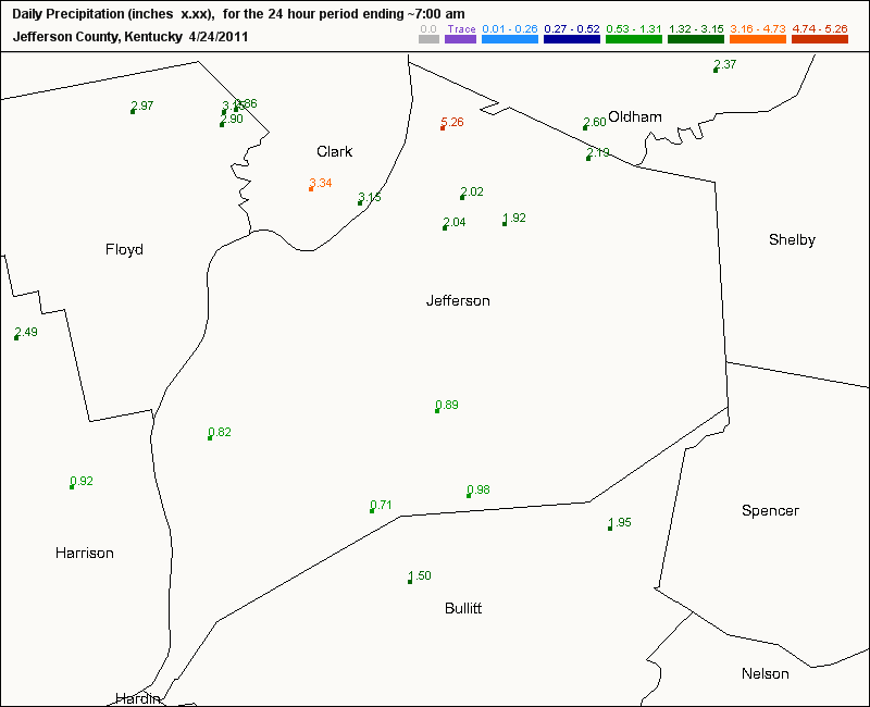
This is from our friends at the CoCoRaHS and some of their 24-hour rainfall amounts in Jefferson county and some adjacent counties. Pretty impressive...Click on the map below.
 By the way, we've all heard the saying, "April showers bring May flowers". Well, it's not only a meteorological or a climatological statement, but it's also a proverb.
The expression "April showers bring May flowers" can mean 'some unpleasant occurrences bring about better things.' In other words, endure the downpours of April, then you'll enjoy the flowers of May. Perhaps a lesson in patience.
I hate to ruin the rhyme, but last I heard, May is the most active month for severe weather around here.
I'll be updating rain totals for us here in Louisville and river levels around the region later today.
MS
Look for additional heavy rains returning to the area later today and tonight.
This is from our friends at the CoCoRaHS and some of their 24-hour rainfall amounts in Jefferson county and some adjacent counties. Pretty impressive...Click on the map below.
The expression "April showers bring May flowers" can mean 'some unpleasant occurrences bring about better things.' In other words, endure the downpours of April, then you'll enjoy the flowers of May. Perhaps a lesson in patience.
I hate to ruin the rhyme, but last I heard, May is the most active month for severe weather around here.
I'll be updating rain totals for us here in Louisville and river levels around the region later today.
MS
1997 Flood Crest to be Breached???
One of the worst flooding events for Louisville in my lifetime occurred in 1997. River levels exceeded 38ft at the McAlpine Upper Gauge, some 15ft above flood stage. The Lower Gauge recorded about 70ft, again some 15ft above flood. I recall helping an older man and his wife clean up after the river inundated the first floor of their home. Water was some 4 ft high in the living room. This was along the Dixie Hwy corridor just past Kosmosdale near West Point.
I dug around and located an interesting archive for the 1997 flood in Louisville. The picture below is a view from the Clark Memorial bridge.
 You can see additional pics and write-up for this event at the following site below:
http://www.crh.noaa.gov/lmk/?n=flood97
Now, Old Man River is on the move again and threatens to breach that 1997 event. Latest river forecasts may be a bit too conservative. The latest forecast had UG at 33ft and LG at just under 65ft. I've compared the '97 event to this one. Yes, in '97, Louisville set the state all-time 24-hr precip record at 10.48". However, the amount of territory that is being/will be affected by this relentless, prolonged period of heavy rain is what's got me concerned.
The setup for our current flooding event has a forecast for more heavy rains right along the Ohio river and points just north and south. All rivers and other tributaries feed into the Ohio. Historical rainfall records have fallen and others will soon be broken over the next few days. This includes locations like Lexington and Frankfort, where April all-time rainfall records have already occurred. Such a prolonged period of heavy rainfall will not allow the River to recede much before additional heavy rains move in.
I expect flooding along the Ohio to continue through the end of the month and into the first part of Derby week. The Great Steamboat Race could be affected along with regular barge traffic on the river. I'll be posting my pics over the course of the next few days right here. I'll be visiting places like West Point, Greenwood boat ramp, Kosmosdale (near where the Ohio Valley drag strip is located), and others.
Keep checking back.
MS
I dug around and located an interesting archive for the 1997 flood in Louisville. The picture below is a view from the Clark Memorial bridge.

http://www.crh.noaa.gov/lmk/?n=flood97
Now, Old Man River is on the move again and threatens to breach that 1997 event. Latest river forecasts may be a bit too conservative. The latest forecast had UG at 33ft and LG at just under 65ft. I've compared the '97 event to this one. Yes, in '97, Louisville set the state all-time 24-hr precip record at 10.48". However, the amount of territory that is being/will be affected by this relentless, prolonged period of heavy rain is what's got me concerned.
The setup for our current flooding event has a forecast for more heavy rains right along the Ohio river and points just north and south. All rivers and other tributaries feed into the Ohio. Historical rainfall records have fallen and others will soon be broken over the next few days. This includes locations like Lexington and Frankfort, where April all-time rainfall records have already occurred. Such a prolonged period of heavy rainfall will not allow the River to recede much before additional heavy rains move in.
I expect flooding along the Ohio to continue through the end of the month and into the first part of Derby week. The Great Steamboat Race could be affected along with regular barge traffic on the river. I'll be posting my pics over the course of the next few days right here. I'll be visiting places like West Point, Greenwood boat ramp, Kosmosdale (near where the Ohio Valley drag strip is located), and others.
Keep checking back.
MS
Saturday, April 23, 2011
Waterlogged...w/UPDATES
8:08pm
Lexington now has 9.43" for the month of April, AN ALL-TIME RECORD RAINFALL for the month of April.
8:00pm
Louisville has now reached 9.15" for the month, ranking #3 on the all-time rainfall list for April. The record is 11.10". Rainfall at the airport for the storm system is 2.88".
7:40pm
I've scanned some recent river forecasts and found some updates. McAlpine Upper expected to reach 33 ft or 10ft above flood stage. Moderate flooding would occur.
Salt River at Shepherdsville expected to crest just below moderate stage at 34ft, but I think those numbers may be adjusted higher based on expected amounts over the next few days.
7:15pm
I hope they're wrong about this one...From now thru Thursday
 5:20pm
Storm reports:
Sparta KY (Owen county) Trees across Hwy 1316; roofs off of outbuildings
Barkley Airport 79 mph wind gust
Downed and uprooted trees in Paducah
Now, t'storm warnings for Breck, Meade, Hardin counties in KY.
2.68" storm total at my location in Valley Station (Louisville)
5:15pm
I'm going to check on storm reports next, but I'm denoting very strong winds indicative of derecho type winds with this bowing segment approaching from the west. Winds at least 70mph possible.
5:05pm
Possible tornadic cell approaching southern parts of Owensboro.
4:50pm
CORRECTION
I knew I was going to do that...Storm total is 2.78" not just today's total. Sorry...but, still think we'll beat that with the next round of storms poised to move in. We needed about another 0.50" or so to beat the daily rainfall record.
4:30pm
Louisville tacked on another 0.51" last hour for storm total of 2.78" and 9.03" for the month.
We only need 0.02" to break the daily record rainfall total set in 1970 for this date. Also, we need 0.06" to move into #3 on the all-time wettest April list.
Lexington still needs 0.06". Heavy rain just north will brush the airport. That should do it.
More on severe weather in a few minutes
4:00pm
Oh yeah, forgot to mention about this thing called a Tornado Watch till 8pm.
Apparent damage in western KY already being reported.
3:25pm
As of 3:00pm, NWS Louisville has now recorded 2.27" for this storm system. And this only partially accounts for a very heavy rain in progress. Rank #5 on all-time rainfall record for April at 8.52"
Flash flood warnings across the board.
Over 1.7" since midnight.
Also, Lexington has recorded 1.4" today. Only 0.06" more and a new all-time rainfall record will be set for the month of April.
Do I need to say more?
As of 10am this morning, total rainfall from this storm system has been 2.02"
Month to date: 8.27"
Rank: 6th wettest April on record
More heavy rain to come, along with a chance for severe storms.
MS
Lexington now has 9.43" for the month of April, AN ALL-TIME RECORD RAINFALL for the month of April.
8:00pm
Louisville has now reached 9.15" for the month, ranking #3 on the all-time rainfall list for April. The record is 11.10". Rainfall at the airport for the storm system is 2.88".
7:40pm
I've scanned some recent river forecasts and found some updates. McAlpine Upper expected to reach 33 ft or 10ft above flood stage. Moderate flooding would occur.
Salt River at Shepherdsville expected to crest just below moderate stage at 34ft, but I think those numbers may be adjusted higher based on expected amounts over the next few days.
7:15pm
I hope they're wrong about this one...From now thru Thursday
Storm reports:
Sparta KY (Owen county) Trees across Hwy 1316; roofs off of outbuildings
Barkley Airport 79 mph wind gust
Downed and uprooted trees in Paducah
Now, t'storm warnings for Breck, Meade, Hardin counties in KY.
2.68" storm total at my location in Valley Station (Louisville)
5:15pm
I'm going to check on storm reports next, but I'm denoting very strong winds indicative of derecho type winds with this bowing segment approaching from the west. Winds at least 70mph possible.
5:05pm
Possible tornadic cell approaching southern parts of Owensboro.
4:50pm
CORRECTION
I knew I was going to do that...Storm total is 2.78" not just today's total. Sorry...but, still think we'll beat that with the next round of storms poised to move in. We needed about another 0.50" or so to beat the daily rainfall record.
4:30pm
Louisville tacked on another 0.51" last hour for storm total of 2.78" and 9.03" for the month.
We only need 0.02" to break the daily record rainfall total set in 1970 for this date. Also, we need 0.06" to move into #3 on the all-time wettest April list.
Lexington still needs 0.06". Heavy rain just north will brush the airport. That should do it.
More on severe weather in a few minutes
4:00pm
Oh yeah, forgot to mention about this thing called a Tornado Watch till 8pm.
Apparent damage in western KY already being reported.
3:25pm
As of 3:00pm, NWS Louisville has now recorded 2.27" for this storm system. And this only partially accounts for a very heavy rain in progress. Rank #5 on all-time rainfall record for April at 8.52"
Flash flood warnings across the board.
Over 1.7" since midnight.
Also, Lexington has recorded 1.4" today. Only 0.06" more and a new all-time rainfall record will be set for the month of April.
Do I need to say more?
As of 10am this morning, total rainfall from this storm system has been 2.02"
Month to date: 8.27"
Rank: 6th wettest April on record
More heavy rain to come, along with a chance for severe storms.
MS
Friday, April 22, 2011
Storm Updates Apr 22
6:50pm
TORNADO WATCH for the area till 2:00am edt.
Still, a number of funnel cloud sightings now across Anderson county and Lawrenceburg. No tornado touchdowns yet.
6:05pm
Tornado warning for parts of Spencer county where strongest rotation will be. Otherwise, at my location during the last hour, just heavy rain and some lightning. No hail or high winds. 0.40" recorded here in Valley Station during the past hour. I'll be updating Louisville's monthly total above this post. Remember, the all-time rainfall record for April is 11.10"
5:05pm
Rainfall estimated 0.5 - 1.2" in the last hour across many sections to our west.
4:35pm
Dewpoints in mid 60's in Louisville as storms approach. LI's now approaching -3. Heavy rain and some hail along with gusty winds expected. Noticing darker clouds to my northwest.
4:25pm
No severe weather reported in KYor IN yet. Some small hail is quite likely falling with some of the stronger cells along with 30-40mph winds.
Dewpoints are becoming sticky at my location
3:35pm
Lightning counts have increase nearly 30% during the past couple of hours.
http://www.strikestarus.com/index.aspx?id=30
I am also noticing an increasing wind threat as storms push thru Jasper. Probably 30-40mph.
That line may approach Louisville area by 5:00pm.
3:15pm
Strong/severe storm moving thru Vincennes IN. Storm report out shortly...
Additional storms are firing in the increasingly unstable airmass.
50-60kt bulk shear to the west. LI's turning increasingly negative locally. Hail still looks to be the main threat but wind threat should increase soon.
2:30pm
Severe Thunderstorm Watch box issued for parts of north central KY and all of southern IN. Large hail has been a primary culprit but damaging wind is also a possibility.
 Some selected probabilities from the SPC include:
Severe wind MOD
Severe hail MOD
Hail>2" LOW
Strong Tornadoes LOW
1:25pm
No thunder in Louisville, just light rain. E'town receiving heavy thunderstorm, with possible dime-size hail.
Looking at current lightning strike activity, lightning count has diminished somewhat over the past hour over MO and IL.
12:25pm
Band of thunderstorms approaching Louisville. Nothing severe yet, but the line is strengthening.
Check this site for latest lightning strikes.
http://www.strikestarus.com/
TORNADO WATCH for the area till 2:00am edt.
Still, a number of funnel cloud sightings now across Anderson county and Lawrenceburg. No tornado touchdowns yet.
6:05pm
Tornado warning for parts of Spencer county where strongest rotation will be. Otherwise, at my location during the last hour, just heavy rain and some lightning. No hail or high winds. 0.40" recorded here in Valley Station during the past hour. I'll be updating Louisville's monthly total above this post. Remember, the all-time rainfall record for April is 11.10"
5:05pm
Rainfall estimated 0.5 - 1.2" in the last hour across many sections to our west.
4:35pm
Dewpoints in mid 60's in Louisville as storms approach. LI's now approaching -3. Heavy rain and some hail along with gusty winds expected. Noticing darker clouds to my northwest.
4:25pm
No severe weather reported in KYor IN yet. Some small hail is quite likely falling with some of the stronger cells along with 30-40mph winds.
Dewpoints are becoming sticky at my location
3:35pm
Lightning counts have increase nearly 30% during the past couple of hours.
http://www.strikestarus.com/index.aspx?id=30
I am also noticing an increasing wind threat as storms push thru Jasper. Probably 30-40mph.
That line may approach Louisville area by 5:00pm.
3:15pm
Strong/severe storm moving thru Vincennes IN. Storm report out shortly...
Additional storms are firing in the increasingly unstable airmass.
50-60kt bulk shear to the west. LI's turning increasingly negative locally. Hail still looks to be the main threat but wind threat should increase soon.
2:30pm
Severe Thunderstorm Watch box issued for parts of north central KY and all of southern IN. Large hail has been a primary culprit but damaging wind is also a possibility.
Severe wind MOD
Severe hail MOD
Hail>2" LOW
Strong Tornadoes LOW
1:25pm
No thunder in Louisville, just light rain. E'town receiving heavy thunderstorm, with possible dime-size hail.
Looking at current lightning strike activity, lightning count has diminished somewhat over the past hour over MO and IL.
12:25pm
Band of thunderstorms approaching Louisville. Nothing severe yet, but the line is strengthening.
Check this site for latest lightning strikes.
http://www.strikestarus.com/
Severe Weather/Flooding Kicks Off Easter Weekend
A very active holiday weekend indeed is unfolding right now primarily to our west and northwest. Look for our weather to begin deteriorating this afternoon in the Louisville area.
At the moment, the severe parameters I've been looking at are pretty tame. However, there were 3 pockets of concern. The closest one of those pockets to us will be harassing St Louis vicinity. A great deal of shear is present all along this warm frontal boundary. Although LI's are not very impressive along with CAPE vals being a non-factor, look for these parameters to become more ominous later today, particularly as they approach the Louisville area.
The other pocket of concern will probably occur later tonight as precip has not even broke out yet in eastern OK and western MO. Shear values are quite high and LI's already in the -4 range along with CAPE vals around 2000. Not bad for this time of day. Of course, dewpoint readings will be on the rise and will help 'juice up' the atmosphere.
If anything, look for quite a bit of heavy rain, especially along and north of the Ohio river. My current thinking is the heaviest rain will fall across water-logged southern Indiana for today. For tonight and tomorrow, that will shift a little bit south in our area. Current thinking is still 2-4", depending on thunderstorms and 'training'.
Graphics and additional thoughts later.
MS
Thursday, April 21, 2011
Breaking It Down
***4:00pm edt UPDATE***
Flash Flood Watch in effect for 2-4" rain
---------------
Quite a bit to get to, so let's get started.
In a previous post, I mentioned Louisville's 124-year long record for Friday April 22 rainfall of 3.08". Here is a map from the HPC that shows the possible rain amounts from now thru Saturday morning.


STRONGLY SHEARED ENVIRONMENT FOR SUPERCELLS...INCLUDING THE
POSSIBILITY FOR A FEW TORNADOES...VERY LARGE HAIL AND DAMAGING
WINDS. THIS ACTIVITY SHOULD SPREAD DOWNSTREAM INTO THE LOWER OH
VALLEY INTO A RECOVERING AIRMASS IN THE WAKE OF NWD SHIFTING WARM
FRONT.
I'm not yet posting my thoughts about the upcoming storm system, as there are too many uncertainties. Yes, I do think there will be severe weather in our region. However, some areas may not get the needed instability for a widespread event like what we just witnessed during the April 19-20 event. We'll see how future forecast models are handling the data for a better indication of our severe weather chances locally.
By the way, while many now confirmed tornadoes have been recorded for many areas near Louisville, we really dodged a bullet, as winds peaked at 52mph at the Airport. No significant damage in my area as well. And yay, the power stayed on.
More updates later.
MS
Flash Flood Watch in effect for 2-4" rain
---------------
Quite a bit to get to, so let's get started.
In a previous post, I mentioned Louisville's 124-year long record for Friday April 22 rainfall of 3.08". Here is a map from the HPC that shows the possible rain amounts from now thru Saturday morning.
As of now, we are included in the 3"+ category. Will it all occur on Friday, though? Tough to say. Regardless, even if the daily record for rainfall does not happen, these amounts will only prolong regional flooding issues, especially along the Ohio river and other smaller rivers in southern Indiana.
By the way, here is a list of the TOP TEN WETTEST APRILS for Louisville.
1 1970 - 11.10"
2 1966 - 9.56"
3 1872 - 9.08"
4 1912 - 8.60"
5 1972 - 8.48"
6 1893 - 7.69"
7 1892 - 7.50"
8 1979 - 7.32"
9 1887 - 7.31"
10 1940 - 7.21"
As of this post, we are at 6.24". With heavy rain expected this weekend and more on tap for next week, we could very well challenge the all-time record rainfall for April. We should at least post in the top 3 wettest Aprils.
I'll be posting the current April rainfall along with other records in jeopardy for the rest of the month just below my Title Page.
In addition, Lexington's all-time record rainfall for April is 9.30". Currently they are around 7.50". Looks like a done deal for them, as they may eclipse the record this weekend.
Next, the severe threat is beginning to loom large once again for our region. The SPC has shifted its hatch marks closer to Louisville now. Take a look.
Many of these areas will quite likely be upgraded to a MODERATE risk, or at least a 45% probability for significant severe weather.
Here is what they are saying:
MODEST INSTABILITY WILL BE IN PLACE BY
MID AFTERNOON FOR ROBUST THUNDERSTORM DEVELOPMENT ACROSS MO WITHIN ASTRONGLY SHEARED ENVIRONMENT FOR SUPERCELLS...INCLUDING THE
POSSIBILITY FOR A FEW TORNADOES...VERY LARGE HAIL AND DAMAGING
WINDS. THIS ACTIVITY SHOULD SPREAD DOWNSTREAM INTO THE LOWER OH
VALLEY INTO A RECOVERING AIRMASS IN THE WAKE OF NWD SHIFTING WARM
FRONT.
I'm not yet posting my thoughts about the upcoming storm system, as there are too many uncertainties. Yes, I do think there will be severe weather in our region. However, some areas may not get the needed instability for a widespread event like what we just witnessed during the April 19-20 event. We'll see how future forecast models are handling the data for a better indication of our severe weather chances locally.
By the way, while many now confirmed tornadoes have been recorded for many areas near Louisville, we really dodged a bullet, as winds peaked at 52mph at the Airport. No significant damage in my area as well. And yay, the power stayed on.
More updates later.
MS
Rain, Rain, What a Pain...
Well, it does not look like we are going to get much of a break from our recent pattern of wet weather. Already the HPC has been putting out 5-day totals exceeding 4" in our area (Louisville).
This Friday, Earth day, will be more like Water day, as our part of the earth will be covered by water. In case you're wondering, the record rainfall total for April 22 is 3.08" in Louisville. I really think we have a shot at breaking that 124-year old record if we get 'training' storms along the warm front.
This will only aggravate the regional flooding issues along the Ohio river and other smaller tributaries in southern Indiana.
In addition, chances for severe weather will be going up again. I'll be looking at that in another post. For now, expect the heavy rains not only for Friday, but well into next week, as some locations will be posting near record rainfall amounts for the month of April.
More later...
MS
Wednesday, April 20, 2011
Confirmed Tornadoes for Apr 19-20 2011
I will be updating this page as NWS survey crews analyze storm damage from this storm system.
Two tornadoes confirmed in Jeffersonville. An EF-0 tornado briefly touched down damaging a shed, shingles, and trees alongs its 0.1 mile journey. Then perhaps the same vortex touched down again with EF-1 damage and wind speeds estimated at 80-90mph for 1.2 miles. A trailer roof was thrown 65 yards along with some 20-25 mobile homes damaged.
Remember the post below about tornadoes skipping? They cannot actually skip since they must be in constant contact with the ground and cloud base. Therefore, the survey crew made the right call by labeling these as 2 separate tornadoes despite the possibility that the same vortex caused the damage in Jeffersonville.
EF-0 tornado confirmed near Frankfort KY. Winds estimated at 65-70mph damaged shingles and several trees along its 4-mile trek.
EF-1 tornado in Oldham county KY. Again, a very brief touchdown, 0.2 mile path length. Just northwest of LaGrange, a barn was destroyed and roof damage at a house and another barn. 90 mph winds estimated.
EF-1 tornado in Simpson county KY near Franklin. 3.3 miles path length with estimated winds 90-95mph. 1 barn destroyed and the roof of another damaged. At least 100 trees uprooted or snapped.
EF-1 tornado in Scott county KY. Northeast of Georgetown, only traveled 0.5 miles with estimated winds 90-95mph. A tied-down trailer overturned, several outbuilding destroyed or damaged, and a garage wall collapsed.
EF-0 tornado in Harrison county IN. Just northeast of Corydon, 65 mph estimated wind speed snapped or uprooted several hardwood and softwood trees along its 0.3 mile journey.
EF-0 tornado in Breckinridge and Meade counties of KY. Along its 11-mile journey occasionally lifting at times, estimated 65-80mph winds destroyed a carport and then threw it across a field, trees snapped/uprooted, shingle damage to a home, and a barn door blown in.
Tuesday, April 19, 2011
NOWCAST Severe Weather Outbreak Apr 19-20 2011
I will be posting some information here in anticipation of a possible severe weather outbreak for our region. So keep checking back for additional details.
***10:45pmUPDATE***
SPC has hatch marks near Louisville meaning strong tornadoes/destructive winds possible.
***8:00pm UPDATE***
NEW Tornado Watch issued for parts of Indiana, west KY. From just northeast of Indy southwest to Owensboro to Hopkinsville and points west of each location till 3:00am edt
In fact, this WATCH encompasses a lot of territory. I don't recall ever seeing a Tornado Watch so large.
***7:30pm UPDATE***
Possible tornado damage now reported in Girard IL where 2 homes damaged and people trapped
Incredible hail reports as well. Lots of golf ball size and larger being reported
Look for possible WATCHES to be issued for Louisville and points west within a couple of hours or so.
Timing of storms in Louisville as of now stands at about 1:00am edt or so. Storms not moving as fast at the moment.
***6:55pmUPDATE***
At least 1 home and 2 barns destroyed in Bowling Green MO
Some reports of softball size hail
In fact, lots of hail reports thus far
***6:10pm UPDATE***
Southern suburbs of Springfield IL watch out for severe weather.
Talk about a warm front; during a 5-hour stretch, Springfield went from 49 to 79 last hour.
-------------
***5:55pm UPDATE***
Have fun trying to get on the LIVE video chase cams
at severestudios.com and tornadoalley.net
------------------------
***5:30pm edt UPDATE***
First tornado warnings out north and west of St Louis
Golf ball to Baseball size hail reported with some of those cells.
SPC has placed hatch marks for greatest chance for strong tornadoes:
I expect these storms to take on average of about 7-8 hours from now to enter Louisville area.
That would be about 12:30am or so. Please turn on those weather radios before going to bed.
----------------------------------
As of this post, a TORNADO WATCH has been posted for areas around St Louis.
For amateur (radio) weather spotters: here is a map depicting the proper repeater frequency
http://www.crh.noaa.gov/lmk/pdf/known_hamradio_repeater_map.pdf
***10:45pmUPDATE***
SPC has hatch marks near Louisville meaning strong tornadoes/destructive winds possible.
***8:00pm UPDATE***
NEW Tornado Watch issued for parts of Indiana, west KY. From just northeast of Indy southwest to Owensboro to Hopkinsville and points west of each location till 3:00am edt
In fact, this WATCH encompasses a lot of territory. I don't recall ever seeing a Tornado Watch so large.
***7:30pm UPDATE***
Possible tornado damage now reported in Girard IL where 2 homes damaged and people trapped
Incredible hail reports as well. Lots of golf ball size and larger being reported
Look for possible WATCHES to be issued for Louisville and points west within a couple of hours or so.
Timing of storms in Louisville as of now stands at about 1:00am edt or so. Storms not moving as fast at the moment.
***6:55pmUPDATE***
At least 1 home and 2 barns destroyed in Bowling Green MO
Some reports of softball size hail
In fact, lots of hail reports thus far
***6:10pm UPDATE***
Southern suburbs of Springfield IL watch out for severe weather.
Talk about a warm front; during a 5-hour stretch, Springfield went from 49 to 79 last hour.
-------------
***5:55pm UPDATE***
Have fun trying to get on the LIVE video chase cams
at severestudios.com and tornadoalley.net
------------------------
***5:30pm edt UPDATE***
First tornado warnings out north and west of St Louis
Golf ball to Baseball size hail reported with some of those cells.
SPC has placed hatch marks for greatest chance for strong tornadoes:
That would be about 12:30am or so. Please turn on those weather radios before going to bed.
----------------------------------
As of this post, a TORNADO WATCH has been posted for areas around St Louis.
For amateur (radio) weather spotters: here is a map depicting the proper repeater frequency
http://www.crh.noaa.gov/lmk/pdf/known_hamradio_repeater_map.pdf
Pre-NOWCAST Updates
After this post, I'll be going into Nowcast mode, awaiting for storms to begin firing. Unfortunately, I won't be participating too much in the action later this evening and overnight as I'll actually be working my 'paid' job. However, will have an excellent view of things at Louisville International Airport.
Check out some of the temperatures, quite a contrast along that warm front. Just click on the image to enlarge.
 That warm front has also been an efficient producer of heavy rain, especially in the northern areas of our region. Here are some rainfall amounts since midnight.
Awaiting the updated information from the SPC...and...
Just out...Still a MODERATE risk for severe storms across the region. Again, my thinking is that they are awaiting data that will help them determine when the Cap will begin to erode and where the best chance for severe weather, especially supercellular ones will occur. At that time, a HIGH risk and Potentially Dangerous Situation tornado watches may be forthcoming later this evening.
The SPC says:
IN A CORRIDOR OF ENHANCED LOW-LEVEL SHEAR FROM E-CNTRL MO EWD
THROUGH CNTRL PARTS OF IL/IND. GIVEN MORE DISCRETE STORM MODES
/I.E. SUPERCELLS/...THIS AREA WILL REPRESENT THE GREATEST RISK FOR
TORNADOES /SOME POSSIBLY STRONG/ FROM LATE THIS AFTERNOON INTO
TONIGHT. OTHERWISE...EXPECT THE DEVELOPMENT OF SUPERCELLS AND LINE
SEGMENTS ALONG COLD FRONT WITH EVENTUAL UPSCALE GROWTH INTO ONE OR
MULTIPLE MCSS/QLCSS. WIDESPREAD OCCURRENCES OF HAIL AND DAMAGING
WINDS /SOME SIGNIFICANT/ ARE EXPECTED ACROSS THE MODERATE RISK AREA
INTO EARLY WEDNESDAY DUE TO THE PRESENCE OF STEEP LAPSE RATES AND
THE WIDE...UNSTABLE WARM SECTOR.
I'll be going into Nowcast mode in my next post later today.
MS
Check out some of the temperatures, quite a contrast along that warm front. Just click on the image to enlarge.
Just out...Still a MODERATE risk for severe storms across the region. Again, my thinking is that they are awaiting data that will help them determine when the Cap will begin to erode and where the best chance for severe weather, especially supercellular ones will occur. At that time, a HIGH risk and Potentially Dangerous Situation tornado watches may be forthcoming later this evening.
The SPC says:
IN A CORRIDOR OF ENHANCED LOW-LEVEL SHEAR FROM E-CNTRL MO EWD
THROUGH CNTRL PARTS OF IL/IND. GIVEN MORE DISCRETE STORM MODES
/I.E. SUPERCELLS/...THIS AREA WILL REPRESENT THE GREATEST RISK FOR
TORNADOES /SOME POSSIBLY STRONG/ FROM LATE THIS AFTERNOON INTO
TONIGHT. OTHERWISE...EXPECT THE DEVELOPMENT OF SUPERCELLS AND LINE
SEGMENTS ALONG COLD FRONT WITH EVENTUAL UPSCALE GROWTH INTO ONE OR
MULTIPLE MCSS/QLCSS. WIDESPREAD OCCURRENCES OF HAIL AND DAMAGING
WINDS /SOME SIGNIFICANT/ ARE EXPECTED ACROSS THE MODERATE RISK AREA
INTO EARLY WEDNESDAY DUE TO THE PRESENCE OF STEEP LAPSE RATES AND
THE WIDE...UNSTABLE WARM SECTOR.
I'll be going into Nowcast mode in my next post later today.
MS
Keep an 'Eye' to the Sky
Check out the latest wording from the SPC:
AN INCREASING POTENTIAL FOR MORE WIDESPREAD DMGG
WIND/POSSIBLE DERECHO CONDITIONS ACROSS PARTS OF IL/IND/KY/TN
TONIGHT. THIS THREAT LIKELY WILL CONTINUE WELL INTO WED MORNING AS
BAND OF 60+ KT SWLY LLJ SWEEPS NEWD IN TANDEM WITH CONVECTIVE SYSTEM
ACROSS LWR TN AND OH RVR VLYS.
Another update will be due out between 12:30 and 1:00 pm edt.
Unfortunately, for many in our region, the advertised supercells and squall line will be arriving after dark according to the latest consensus. While it's always suggested to keep an eye to the sky for rapidly changing weather conditions, it is much more difficult at night.
That's why I, and the entire meteorological community, strongly urge everyone to purchase a weather radio. This will be your 'eye' to the sky, along with local media.
Weather radios that come with programmable SAME codes is preferred. Therefore, you can program only the counties you want the alert tones to sound for. I always suggest programming counties just to your west, northwest, and southwest (in addition to your own county), as this is where storms usually come from.
I have provided two links in the Miks Piks section of my blog that gives you the 6-digit SAME code for your county and any adjacent counties. They are entitled Kentucky SAME and Indiana SAME.
More updates in a future post...
MS
Tornado Targets
As of early this morning, here is the tornado risk for the region. Quite widespread as this encompasses a large chunk of real estate. I still think the SPC will place parts of the region in a 'HIGH' risk area for severe weather, especially western KY. Though with the expected Cap to be in place, they may want to wait and monitor the situation closely as the cap begins to erode and thunderstorms quickly fire.
TORNADO RISK
 And here is the overall severe weather threat for the region:
 Another update from the SPC should be out later this morning. Check back for further updates as this potentially dangerous system tracks our way!
MS
TORNADO RISK
MS
Monday, April 18, 2011
TORNADO SEASON - Do Tornadoes Skip???
As part of my interest in tornadoes and the significant damage they can cause, I've chosen to discuss some aspects of tornadoes that you may not have already known, or perhaps you already knew....
In this section, a question about tornadoes is, "Do tornadoes really skip?"
First, let's define what a tornado is:
"...in order for a vortex to be classified as a tornado, it must be in contact with the ground and the cloud base."
Therefore, in a literal sense, a tornado cannot really skip, since it must be in contact with the ground.
Stories of skipping tornadoes usually mean:
1) There was continuous contact between vortex and ground in the path, but it was too weak to do damage;
2) Multiple tornadoes happened; but there was no survey done to precisely separate their paths (very common before the 1970s);
3) There were multiple tornadoes with only short separation, but the survey erroneously classified them as one tornado.
(Thanks to Roger Edwards of the Severe Prediction Center)
I will be looking at our severe weather chances in the next post. Stay tuned. A MODERATE risk is already out there for the region. And as I said previously, some may go to a HIGH risk chance for the Tue-Wed time frame. Chance for storms tonight into tomorrow morning may bear watching as well.
MS
Grading the Ensembles...
Every now and then, I check on some aspect of long-term forecasting to see how reliable such forecasts are, and if they are even worth considering. For example, for the month of February, I performed an analysis of the CPC's monthly forecast. I considered several random locations across the U.S., measured their monthly temps and precip against normal monthly values. Looking at the monthly forecast, I discovered that the CPC could have done better, but their forecast for the end of the month really helped their overall grade: C+
This month, I'll be looking at the CPC forecast for April. However, recently, I performed an analysis of the GFS Ensembles for 2m Temp Depart From Normal. On April 1, I looked at the Ensembles for April 2-12 and used Louisville, Indianapolis, Nashville, St Louis, Bowling Green, and Memphis for my analysis. I looked at all daily normal highs for each city during the period, considered the shaded regions indicating the departure from normal, and plugged in the actual highs against the forecast.
The results have been tallied. I thought that I was very generous in my grading process, especially since forecasting temps beyond 3 days can be very inaccurate. However, one notable problem I found with the ensembles during this time frame was the gross underestimation of above normal temps. The teleconnectors, NAO and PNA, both indicated above normal temps for this time period while the GFS ensembles mainly forecasted normal to below normal readings.
Here was a breakdown of the grades:
Louisville D
Indianapolis C
Nashville C+
Memphis B-
Bowling Green C
Overall grade for the region was: C
Again, I was very generous in the grading process. I would like to see the percentages come up just a bit. It could've been just a bad stretch. I will perform another analysis starting tomorrow, April 19, and run through the end of the month.
The teleconnectors I'm using, the NAO and PNA, are showing a cooldown toward the last part of the month. Possible below normal temps for a few days may occur. I'll see how the GFS Ensembles for 2m Temp Departures From Normal handle its forecast for this period...
I'll have updates on our impending severe weather chances this week soon. Plus, I'm going to discuss whether tornadoes 'skip' or not. Pretty interesting stuff. Come on back now, ya hear.
MS
Sunday, April 17, 2011
One More Round...Why Not.
After this past 3-day severe weather episode, can it get any worse? The death toll from this recent storm system has claimed at least 43 lives, mostly tornado-related. Preliminary tornado reports from the past two days were over 200. Some of those reports may be from the same tornado, though. Nevertheless, I believe the storm system 'peaked' in intensity as it crashed through NC and VA. One of the hardest hit areas was in Askewville NC in Bertie county. 10 fatalities and at least 50 injuries had been reported.
So, can it get any worse? Umm, maybe. The tornadoes are becoming stronger as we progress into this the tornado season. Please review the tornado safety tips in the Miks Piks section of my blog. Severe storms are already anticipated before midweek and we could be in the crosshairs this time. Now is the time to make preparation! Hats off to a quick-thinking manager at a Lowe's Home Improvement center in NC. While a tornado was bearing down on his store, which was ultimately flattened, he had gathered some 100 customers and employees to an area of the store free from flying glass and other debris. Last I had heard, there were no serious injuries, if any at all. He had already made preparations for the 'just-in-case' scenario. Now is the time for us to do the same.
I'll be talking about more tornado segments soon and will be closely watching the SPC's thoughts about impending severe weather for the upcoming week. Look for MODERATE chances and perhaps even a rare HIGH chance probability for severe weather in some areas. More large and long-track tornadoes are expected.
Whew. Time to catch a breath.
More updates later.
MS
Saturday, April 16, 2011
Earth Day Coming This April 22 on Friday
Earth Day 2011 falls on a Friday this year, as always on the date April 22. I found a few community events you may be interested in that will be ongoing through the end of the month.
Camper Appreciation & Earth Day Celebration! Join us as we celebrate Earth Day and show our appreciation for our campers! Spend Friday night in the campground at regular price and get Saturday night FREE! Nature related activities will be provided all weekend long!Come on out and we will get the camping season started together!
Location: Rough River Dam State Resort Park, 450 Lodge Road, Falls of Rough, Kentucky
Date and time: Friday, April 29 through Sunday, May 1– 10:00 a.m. – 2:00 p.m.
Contact: Sheila Jones, (800) 325-1713, sheila.jones@ky.gov
Earth Day Festival - Louisville Zoo It’s a party for the planet to celebrate Earth Day! You can learn about the zoo’s conservation efforts and visit environmental displays by some of our eco- partners. $2 admission fee.
Location: Louisville Zoo, 1100 Trevilian Way, Louisville, Kentucky
Date and time: Saturday, April 23 – 10:00 a.m. – 5:00 p.m.
Contact: (502) 459-2181
6th Annual Garrard County Earth Day Festival TEACH, The Earth Angels and Community Hearth, Inc. 6th Annual Earth Day Festival
Location: Garrard County Fairgrounds, US 27, Lancaster, Kentucky 40444
Date and time: Saturday, April 30 – 10:00 a.m. – 5:00 p.m.
Contact: Leslie Worley (859) 548-5080
I never knew that Garrard County was where singer John Michael Montgomery shot his video "Sold" (The Grundy County Auction) in 1995.
Of course, it should not be that much of a surprise since JMM was born in nearby Danville in Boyle county.
The video was filmed at the stockyards, which has been closed since summer of 2007.
http://www.youtube.com/watch?v=oMxio_lrybM&feature=fvsr
Friday, April 15, 2011
Tracking Severe Weather
Deja vu. Have we done this before? Another busy weather day as severe weather with tornadoes is expected. Even in parts of our region exists a possibility for tornadoes. Stay tuned to local weather media and your weather radios for the latest updates. Also, I'll be tracking any storms that may pose a risk to our region.
***6:10pm UPDATE***
Tennis ball size hail in McComb MS along with wind damage
So far, no confirmed fatalities with today's storms but about a dozen injuries, some serious.
Impressive line approaching western KY. Paducah, watch out!
***5:20pm UPDATE***
Severe T'storm Warning for St Louis
http://www.earthcam.com/usa/missouri/stlouis/kiener/
***5:10pm UPDATE***
Haven't heard or read anything yet, looks like 'hook' signature in McComb MS
We have 33 preliminary tornado reports so far today (since 7:00 am edt)
***4:50pm UPDATE***
Possible tornado near Meridian MS
Try this site in addition to severestudios:
http://www.tornadoalleylive.com/subindex/weather/maps
***3:55pm UPDATE***
Possible large tornado approaching Tuscaloosa AL
Severestudios web site must be pretty busy...can't get through at the moment.
***3:30pm UPDATE***
Here is a cool shot of satellite imagery from NWS Louisville
 Looking at the 'numbers' that support severe weather to our west, instability is increasing in west KY.
LI's approaching -5, while surface CAPES and MLCAPES increasing as well. Dewpoints on the rise...
 Dewpoint readings have approached the minimum 55-60 degree criteria that could support future tornadic cells in west KY. If anything, hail still looks like a good bet.
Check out http://www.severestudios.com/
***3:20pm UPDATE***
Here is the latest product from the SPC for HAIL chances
 As you can see, hail looks to be the primary threat with the system for west KY and TN and parts of MO and IL. However, the tornado threat still has not diminished. Tornadoes are still possible today for these areas.
***3:10pm UPDATE***
I'll be posting additional data about our severe weather chances. Storms are really firing nicely in Missouri and moving east. 23 preliminary reports of tornadoes today. Several warnings are still out. Expect it to get worse. 9 confirmed fatalities from OK and AR yesterday. Possibly 2 more reported today in MS.
***2:40pm UPDATE***
Check out http://www.severestudios.com/ for LIVE storm chasing. Cars flipped from apparent tornado in Clinton MS.

***2:13 pm UPDATE***
Cars flipped along I-20 near Jackson MS. Reports of fatalities
As of 2:00pm, 16 preliminary reports of tornadoes now.
***2:00 pm UPDATE***
New Tornado Watch box for Western KY
----------------------------------------
***1:30 UPDATE***
Apparent tornado barely misses elementary school in Clinton. No obvious damage to the school but trees across street have been snapped off and power is out at the school.
----------------------------------------
As of the 1:00 pm edt report, 10 preliminary reports of tornadoes have been received thus far, for those interested in their severe weather poll votes.
Jackson MS has sustained some tornado damage. More on that in a little bit.
Yazoo City MS may have escaped without one today. However, the threat is still there for now.
Light rain at my location with less than 0.20" so far. I'll be updating my thoughts on severe weather chances in a little bit as well.
MS
***6:10pm UPDATE***
Tennis ball size hail in McComb MS along with wind damage
So far, no confirmed fatalities with today's storms but about a dozen injuries, some serious.
Impressive line approaching western KY. Paducah, watch out!
***5:20pm UPDATE***
Severe T'storm Warning for St Louis
http://www.earthcam.com/usa/missouri/stlouis/kiener/
***5:10pm UPDATE***
Haven't heard or read anything yet, looks like 'hook' signature in McComb MS
We have 33 preliminary tornado reports so far today (since 7:00 am edt)
***4:50pm UPDATE***
Possible tornado near Meridian MS
Try this site in addition to severestudios:
http://www.tornadoalleylive.com/subindex/weather/maps
***3:55pm UPDATE***
Possible large tornado approaching Tuscaloosa AL
Severestudios web site must be pretty busy...can't get through at the moment.
***3:30pm UPDATE***
Here is a cool shot of satellite imagery from NWS Louisville

LI's approaching -5, while surface CAPES and MLCAPES increasing as well. Dewpoints on the rise...
Check out http://www.severestudios.com/
***3:20pm UPDATE***
Here is the latest product from the SPC for HAIL chances
***3:10pm UPDATE***
I'll be posting additional data about our severe weather chances. Storms are really firing nicely in Missouri and moving east. 23 preliminary reports of tornadoes today. Several warnings are still out. Expect it to get worse. 9 confirmed fatalities from OK and AR yesterday. Possibly 2 more reported today in MS.
***2:40pm UPDATE***
Check out http://www.severestudios.com/ for LIVE storm chasing. Cars flipped from apparent tornado in Clinton MS.
***2:13 pm UPDATE***
Cars flipped along I-20 near Jackson MS. Reports of fatalities
As of 2:00pm, 16 preliminary reports of tornadoes now.
***2:00 pm UPDATE***
New Tornado Watch box for Western KY
----------------------------------------
***1:30 UPDATE***
Apparent tornado barely misses elementary school in Clinton. No obvious damage to the school but trees across street have been snapped off and power is out at the school.
----------------------------------------
As of the 1:00 pm edt report, 10 preliminary reports of tornadoes have been received thus far, for those interested in their severe weather poll votes.
Jackson MS has sustained some tornado damage. More on that in a little bit.
Yazoo City MS may have escaped without one today. However, the threat is still there for now.
Light rain at my location with less than 0.20" so far. I'll be updating my thoughts on severe weather chances in a little bit as well.
MS
Tornado Threat For Some...
The SPC has come out with its latest graphic for tornado chances and possible locations:
This graphic may be updated early this afternoon.
But as you can see, most of the action should stay south near MS and AL. However, notice how the SPC has hatched areas near western KY, southern IL, and western TN. That should be associated with the actual low that will be tracking through the region. With so much cyclonic action and shear available, isolated tornadoes can easily spin up. Something to watch for.
I'm surprised by the number of preliminary tornado reports some have entered in the Severe Weather Poll beginning at 7:00 am edt today and ending at 7:00 am edt Saturday morning. Remember, this is for the entire U.S., not just KY.
My current thinking is that at least 20 preliminary tornado reports will be forthcoming from this system today and tonight. Severe weather will be a possibility across the state today. So, heads up and keep an eye to the sky. Then, at night, keep those weather radios in alert mode. Stay safe. We'll talk again.
MS
Thursday, April 14, 2011
Severe Weather Polls
Another significant tornado outbreak is in the developing stage. And all the action gets started today. Will this outbreak be as bad as some of the previous ones? What do you think? Here's your chance to chime in on what you think will happen.
 As you can see, parts of the Gulf coast states are the primary targets on Friday, April 15. However, that does not mean that tornadoes will not occur outside of those areas. So, what do you think?
Therefore, SEVERE WEATHER POLL 1 asks "How many preliminary tornado reports will there be on Friday, April 15 2011?" The beginning of the poll actually occurs at 6:00 am cdt and ends exactly 24 hours later at 6:00 am cdt on Saturday, April 16. I will be using the SPC severe weather page that updates the preliminary count. You have until 6:00 am cdt or 7:00 am edt to submit your votes.
In addition, I have included a BONUS question that requires either a yes/no vote. Yazoo City MS has been hit by tornadoes within the past couple of years. During this upcoming possible outbreak, "Will Yazoo City see another tornado?" Again, submit your votes by 7:00 am edt on Friday, April 15.
More updates on our local weather coming soon...
MS
Wednesday, April 13, 2011
This Is TORNADO Season!
While tornadoes can occur at anytime of the year, most occur from April through June here in the U.S. In fact, during the past 3 years, an average of 803 actual tornadoes have occurred during these 3 months. Let's put that in perspective. So far this month, there have been 118 preliminary reports of tornadoes. Recently, even Kentucky has been plagued by numerous tornadoes already this year, a preliminary number of 27.
However, tornado season is really just getting started. It's important that people understand how to keep safe. In 2010, there were 45 tornado fatalities. Breaking that down while highlighting the most troublesome statistics, 20 of those fatalities occurred in mobile homes, 7 occurred in vehicles, and 6 occurred in the open or outside.
Already in 2011, 3 tornado fatalities have already occurred with 2 occurring in mobile homes, one in TN and the other in GA. While the other tornado fatality occurred in LA, each of the 3 tornadoes were rated an EF-2 on the Enhanced Fujita Scale.
***As part of Tornado Season, I'll be dedicating a significant portion of my blog to this powerful and dangerous weather event.***
I'll be discussing various aspects of tornadoes, but first and foremost that all should be made aware of is tornado safety. Flying Debris is the greatest danger in tornadoes. Please consult the following link in order to know how to remain safe before, during, and after a tornado touchdown.
Tornado Safety
http://www.spc.noaa.gov/faq/tornado/safety.html
As Tornado Season continues, I'll be posting links like this in the Miks Piks section of the blog. Remember, stay safe out there and get one of those weather radios!
MS
Preliminary Thunder Forecast
As with our weather heroes, my own personal take on the forecast for Thunder could change, based on position of Low pressure on Saturday. Before that, look for possibly strong/severe storms with another heavy rain threat.
SPC says:
 ...and the HPC says
 Of course, we'll keep an eye on this, as river levels will continue to rise throughout the rest of the week and on into the Thunder weekend. Minor flooding is still forecast along the Ohio river. This may prompt some cancellation of water shows. In addition, any boating may be limited by the high water and driftwood dangers.
At the moment, my forecast for Thunder:
Rain before 8am then drizzle or light showers with low ceilings (that could affect air show). Temps near 60 very early then falling throughout the day. Windy. Temps at the fireworks show looks to be in the mid to upper 40's. Smoke from the fireworks looks to be on the KY side but brisk winds should quickly disperse that issue.
Come back and check for further updates on the heavy rain threat, severe weather threat, and hopefully an improving Thunder forecast.
MS
SPC says:
At the moment, my forecast for Thunder:
Rain before 8am then drizzle or light showers with low ceilings (that could affect air show). Temps near 60 very early then falling throughout the day. Windy. Temps at the fireworks show looks to be in the mid to upper 40's. Smoke from the fireworks looks to be on the KY side but brisk winds should quickly disperse that issue.
Come back and check for further updates on the heavy rain threat, severe weather threat, and hopefully an improving Thunder forecast.
MS
Tuesday, April 12, 2011
Flooding Update
I recorded over 3" at my location during this storm event, most of which fell late last evening through the overnight hours. The slow eastward progression was hampered further by an apparent deformation zone, where it seemed like the rain was not moving at all. We like deformation zones in winter but NOT spring. In addition, since I've received nearly 4" of rain during the past 7 days, my basement is again letting me know about it. At least this time I'm top of the problem because of great timing. I got in from work early this morning and the water was just starting to trickle in.
Speaking of problems and timing, could not be any worse timing for the Thunder weekend coming up. A flood warning is in effect for the Ohio River upper and lower gages of McAlpine. The crest is expected to occur sometime on Friday, with minor flooding occurring. However, guess where that minor flooding will be occurring? Yep, right along the waterfront!
In addition, more heavy rain possible along with a chance for severe storms coming up by Friday. I'm away from my normal computer, so can't update with any special tools at the moment.
Will try to post later...\
MS
Monday, April 11, 2011
'Miks Six' April 11 2011
In this segment called Miks Six, I'll feature some news headlines that perhaps you haven't heard yet or maybe you have. I try to locate unusual stories or segments on just about anything, though I try to find more weather stories than anything else. See what you think. I hope you like them...
Have a good day. Keep checking back for another installment of Miks Six
MS
- During the past few weeks, extreme weather has led to record ozone depletion over the Arctic. The unprecedented loss had reached about 40 percent depletion by the end of March. This is an "extremely significant drop in total ozone content over a wide area."
- Fox affiliate WXIX unveiled an interesting weapon in the Cincinnati area this week: a camara mounted 313 feet off the ground at the center of the King's Island amusement park.
- Our neighbors just over the mountains at Virginia Tech are offering new degrees, among them and closest to being implemented is a meteorology degree, making it the first school in Virginia to offer such.
- On April 6, a bright fireball streaked across the skies of Tennessee. First noticed by the Air Force base in Tullahoma, the meteor measured approximately 2ft in diameter and weighed about 200 lbs. Traveling at 9 miles per second, the hunt is on for any surviving fragments expected to be found near the Kentucky border.
- Lost Springs WY, population 1??? Well, in 2000 Census survey, there were actually 5. They must have forgot to look on the other side of the road, recalls the one resident, which included 4 other residents. According to the latest 2010 census, population now stands at 4. Since 2000, two residents had died and one newcomer moved in.
- For you who enjoy reading about weather, here's a selection from assorted professionals in the field:
Meteorology Today by C. Donald Ahrens
Storm Warning by Nancy Mathis
F5 by Mark Levine
The Perfect Storm by Sebastian Junger
Northeast Snowstorms by Paul Kocin and Lee Uccellini
Any book by Tim Vasquez's Forecaster's Handbook Series
Have a good day. Keep checking back for another installment of Miks Six
MS
Sunday, April 10, 2011
***Special*** Looking at Apr 9 2011 storm
Part one - April 9 video footage of storm clouds approaching my storm spotting location in Valley Station.
I'll be posting the actual storm in progress with heavy rain and hail along with intense lightning a little bit later today...in Part 2
***1:30 pm edt UPDATE***
And now for part 2...
Also, I'll be posting a NEW segment on the blog called Miks Six. I'll locate stories and/or weather bits that you may have or have not heard or read. I hope you find it interesting. Check it out. It's coming soon...
MS
Saturday, April 9, 2011
The NUMBERS Game
Yes, this weekend, I'll be focusing on the 'numbers' from the SPC to help determine our severe weather opportunities.
11:30 am edt UPDATE
Power outage update
http://stormcenter.lge-ku.com/default.html
Just getting back from my storm spotter location here in Valley Station
I will say that we had marble size hail, lots of lightning, and torrential rain. Winds were not much of an issue, less than 40mph.
I hope to post video footage sometime today, 3 different installments of about 10 total minutes.
10:15 am edt UPDATE
t'storm WARNING for several counties just west of Louisville
Line appears to be intensifying especially areas approaching Breck and Meade counties. It is moving this way. I'll be stationing myself at my storm spotting location soon. And yes, I'll have camara and video ready just in case...
10:00 am edt UPDATE
T'storm WARNING for the Jasper area for that bowing segment depicted several minutes ago.
Look for these storms to move near or into the Louisville area between 11 and 11:30. Right now, if this thing holds, the bowing line, the apex, will be in Louisville or just north by 11 or so.
At this time (9:30 am edt), a line of strong/severe storms is currently moving across western IN and western KY. So far, only one report of severe weather, 1" hail in Knox county IN. I'm also noticing a slight weakening trend in the southern part of the line. That could be temporary. The SPC has much of KY in a Severe Thunderstorm WATCH until the early afternoon.
The 'numbers' are NOT showing me much in the way of support for severe weather. However, warm fronts can and often produce efficient amounts of heavy rain and especially hail during severe weather periods.
Dewpoints in Louisville and points north and east are not very favorable
LI's have been fairly stable for the last few hours. Closest negative LI's reside across western parts of KY
Helicity vals modestly high across the region thus some spin in the atmosphere capable of supporting hail and theoretically tornadoes.
CAPE and MLCAPE pretty tame
Overall, hail appears to be the main threat with this complex of storms. However, let's keep watch on the radar trends for further strengthening as this line rapidly moves east. Although the southern line appears to be weakening, the overall complex is generating its own 'energy' to support severe weather, especially north of the Ohio river. At this time, it appears the line is trying to bow west of Jasper IN.
MS
Friday, April 8, 2011
Keep On the Watch...
At 2:00pm edt, nothing really showing up on radar. However, don't let that fool you. The atmosphere is becoming destabilized. I'm impressed by the 'numbers' that are showing up for support of severe weather. Will this become a widespread event if it materializes? Hard to say at least for the moment. But the SPC is putting most of Kentucky on alert for a possible WATCH to be issued within the next couple of hours. By then, storms will be firing to our west and northwest.
Based on the 'numbers' that I'm looking at, all we need now is a trigger for storms to develop. All of the parameters are in place for strong/severe storms:
Here are a few parameters I'm looking at as of 2:00pm:
CAPE approaching 2000
MLCAPE between 1000-1500
LI near -5 in places
0-1km SR Helicity 200 in southern and central KY
30-50kt low level and mid-level winds
There is a short wave impulse that will be traversing just north of the Ohio river. At this time, it appears that storms could fire soon. If we don't get any storms here (Louisville) by 6:00-7:00 pm, that means the bulk of the energy will already be past Louisville and will likely affect areas of southern Ohio and east central and eastern KY. Look out for large hail and strong winds. Isolated tornadoes across the central and east central parts a possibility.
More updates later...
MS
Thursday, April 7, 2011
Severe Weather Season - HIGH Gear
If you are a fan of severe weather, we have a treat for you...or should I say at least 3 treats.
 The SPC has placed the region in a slight risk for 3 consecutive days. Perhaps, you prefer to listen to our weather heroes. You can also use the tools the pros use. And you can find them on the SPC Web site that I have posted in the Miks Piks section. In fact, during the peak 'tornado' season (Apr-Jun), I'll be posting links in this section of the blog.
However, be careful how you try to interpret the 'numbers'. One common mistake I keep making is that all of the severe weather parameters are in place, but no severe weather occurs. Why? Often, it's because the atmosphere several thousand feet high is too warm to support any upward development for clouds because the air parcels rising into this layer become cooler than the surrounding air; therefore, no thunderstorms. We call that a Cap.
That same cap can also act like a lid. Conditions at the surface continue to destabilize while the air above basically traps the 'boiling' contents.
 However, when that cap erodes or breaks, then thunderstorms can explode in a hurry and a fury, as was indicated by this past historic severe weather outbreak.
With the upcoming storm system, I don't know if we'll be dealing with a cap or not because the Low will have plenty of cool air aloft to support hail stones, microbursts, heavy rainfall, and isolated tornadoes. I still think the main event will occur near the end of the severe weather period, the last of the 3-day period, as a cold front with an accompanying squall line produces damaging winds in its wake.
Well, another update is about due from the SPC...so I'm going to check it out. Be back soon.
MS
However, be careful how you try to interpret the 'numbers'. One common mistake I keep making is that all of the severe weather parameters are in place, but no severe weather occurs. Why? Often, it's because the atmosphere several thousand feet high is too warm to support any upward development for clouds because the air parcels rising into this layer become cooler than the surrounding air; therefore, no thunderstorms. We call that a Cap.
That same cap can also act like a lid. Conditions at the surface continue to destabilize while the air above basically traps the 'boiling' contents.
With the upcoming storm system, I don't know if we'll be dealing with a cap or not because the Low will have plenty of cool air aloft to support hail stones, microbursts, heavy rainfall, and isolated tornadoes. I still think the main event will occur near the end of the severe weather period, the last of the 3-day period, as a cold front with an accompanying squall line produces damaging winds in its wake.
Well, another update is about due from the SPC...so I'm going to check it out. Be back soon.
MS
Wednesday, April 6, 2011
More Strong/Severe Storms Coming This Weekend?
From the SPC: This pertains to Apr 8/9 time frame...
...OH VALLEY...
A SURFACE LOW ATTENDANT TO THE MIDWEST/OH VALLEY SHORTWAVE TROUGH
INITIALLY LOCATED OVER IL...AND AN ESEWD EXTENDING WARM FRONT...
WILL SHIFT EWD ON FRIDAY. THE SURFACE LOW SHOULD REACH ERN OH BY
09/00Z. LOW LEVEL SWLY FLOW WILL ADVECT MOISTURE INTO THE UPPER
OH/TN VALLEYS BENEATH AN EWD EXTENDING PLUME OF STEEP MIDLEVEL LAPSE
RATES WITH SURFACE DEWPOINTS IN THE LOWER 60S REACHING SRN OH/WRN WV
BY FRIDAY AFTERNOON. THIS COMBINED WITH SURFACE HEATING IS EXPECTED
TO SUPPORT A MODERATELY UNSTABLE WARM SECTOR. FORCING FOR ASCENT
WITH THE TRANSIENT SHORTWAVE TROUGH IS EXPECTED TO ALLOW TSTMS TO
DEVELOP FROM W-E ACROSS THE OH VALLEY WITH EFFECTIVE BULK SHEAR OF
40-45 KT RESULTING IN ORGANIZED STRONG TO SEVERE STORMS.
So far, it doesn't look like as widespread of an event than our previous one. But, I'll keep you updated. Thing to look for is how storms develop to our west as the storms appear to have a w-e orientation. Also, keep an eye on dewpoint, low-level jet, Lifted Indices, Mixed-Layer CAPE, Mid and Low-level Lapse rates, and freezing levels typically around 7,000-10,000 foot levels.
Nice day out there. Quite windy, though. Time to get back to the yard...
MS
Subscribe to:
Posts (Atom)
-
Recently, I noticed that our days have now begun to shorten. However, our sunset here in Louisville still remains at 9:10pm edt. Starting th...
-
 In July of this year, I did a segment about the latest sunsets in the eastern time zone. This corresponded nicely with the summer solstice a...
 -
A 1 Temperature C Humidity F Heat Index 2 81 82 86.82 This is an Excel spreadsheet program. Fairly ...
