Deja vu. Have we done this before? Another busy weather day as severe weather with tornadoes is expected. Even in parts of our region exists a possibility for tornadoes. Stay tuned to local weather media and your weather radios for the latest updates. Also, I'll be tracking any storms that may pose a risk to our region.
***6:10pm UPDATE***
Tennis ball size hail in McComb MS along with wind damage
So far, no confirmed fatalities with today's storms but about a dozen injuries, some serious.
Impressive line approaching western KY. Paducah, watch out!
***5:20pm UPDATE***
Severe T'storm Warning for St Louis
http://www.earthcam.com/usa/missouri/stlouis/kiener/
***5:10pm UPDATE***
Haven't heard or read anything yet, looks like 'hook' signature in McComb MS
We have 33 preliminary tornado reports so far today (since 7:00 am edt)
***4:50pm UPDATE***
Possible tornado near Meridian MS
Try this site in addition to severestudios:
http://www.tornadoalleylive.com/subindex/weather/maps
***3:55pm UPDATE***
Possible large tornado approaching Tuscaloosa AL
Severestudios web site must be pretty busy...can't get through at the moment.
***3:30pm UPDATE***
Here is a cool shot of satellite imagery from NWS Louisville
Looking at the 'numbers' that support severe weather to our west, instability is increasing in west KY.
LI's approaching -5, while surface CAPES and MLCAPES increasing as well. Dewpoints on the rise...
Dewpoint readings have approached the minimum 55-60 degree criteria that could support future tornadic cells in west KY. If anything, hail still looks like a good bet.
Check out http://www.severestudios.com/
***3:20pm UPDATE***
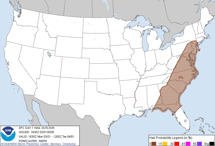
Here is the latest product from the SPC for HAIL chances
As you can see, hail looks to be the primary threat with the system for west KY and TN and parts of MO and IL. However, the tornado threat still has not diminished. Tornadoes are still possible today for these areas.
***3:10pm UPDATE***
I'll be posting additional data about our severe weather chances. Storms are really firing nicely in Missouri and moving east. 23 preliminary reports of tornadoes today. Several warnings are still out. Expect it to get worse. 9 confirmed fatalities from OK and AR yesterday. Possibly 2 more reported today in MS.
***2:40pm UPDATE***
Check out http://www.severestudios.com/ for LIVE storm chasing. Cars flipped from apparent tornado in Clinton MS.
***2:13 pm UPDATE***
Cars flipped along I-20 near Jackson MS. Reports of fatalities
As of 2:00pm, 16 preliminary reports of tornadoes now.
***2:00 pm UPDATE***
New Tornado Watch box for Western KY
----------------------------------------
***1:30 UPDATE***
Apparent tornado barely misses elementary school in Clinton. No obvious damage to the school but trees across street have been snapped off and power is out at the school.
----------------------------------------
As of the 1:00 pm edt report, 10 preliminary reports of tornadoes have been received thus far, for those interested in their severe weather poll votes.
Jackson MS has sustained some tornado damage. More on that in a little bit.
Yazoo City MS may have escaped without one today. However, the threat is still there for now.
Light rain at my location with less than 0.20" so far. I'll be updating my thoughts on severe weather chances in a little bit as well.
MS
Subscribe to:
Post Comments (Atom)
Tornadoes on Easter Sunday
This is a worse case scenario. Tornadoes and flooded, blocked roadways making for great difficulties reaching residences affecting hard hit ...
-
Recently, I noticed that our days have now begun to shorten. However, our sunset here in Louisville still remains at 9:10pm edt. Starting th...
-
In July of this year, I did a segment about the latest sunsets in the eastern time zone. This corresponded nicely with the summer solstice a...
-
A 1 Temperature C Humidity F Heat Index 2 81 82 86.82 This is an Excel spreadsheet program. Fairly ...


No comments:
Post a Comment