Tuesday, January 31, 2017

Look Up In the Western Sky Tonight

Hopefully, skies will clear enough.
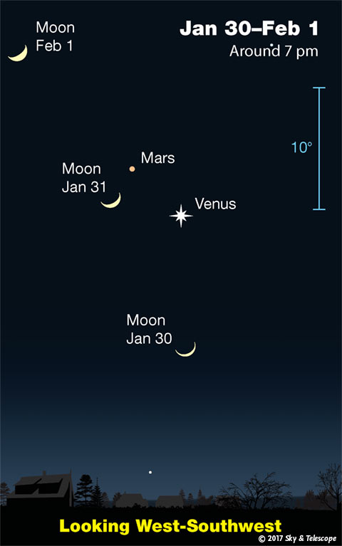
Moon, Venus, Mars, Jan. 30-31, 2017

This is what it will look like tonight.

The men from Mars and the women from Venus will have the chance to share the sky with the moon nearby.

MS

Monday, January 30, 2017

One Year Ago...Ice Jam Blocks Off Community

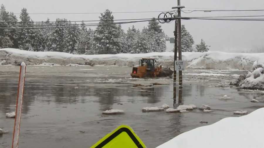
About a year ago, an ice jam along the south fork of the Yuba River in the Serene Lakes Community of California caused some concerns as flooding blocked the only way in or out of the area...

Flooding cuts off Nevada County community

It took a while to bust through the ice, but heavy equipment had been brought in and eventually, residents and vacationers were allowed to return. El Nino was the blame as snowmelt intensified, sending chunks of ice downstream.

source (http://www.kcra.com/article/ice-dam-causes-flooding-in-nevada-county-1/6426994


MS


MikJournal Monday 01/30/2017...More Projections and Dipping Dots

When I measured the snowfall on my snowboard yesterday after a brief, and my only, moderate snow shower, I may have crushed the constitution of the snow flakes that resembled Dipping Dots. I took the required 3 measurements and averaged them out, yet all of them measured less than 0.1". If I could have only brushed aside some of the circular sensation, there were a few instances of 'piling' I could have measured. I am quite sure I could have come up with at least 0.1" that way. But, oh well. A dusting is what I recorded.

The NWS Louisville office at the airport registered 0.3". That's a lot of Dots, in my opinion. Then again, the nature of these snow showers was very location-specific. I have read reports of one part of a county having the ground whitened, but just a few miles down the road, only a few flakes flew.
I think I'm just a sore loser.

Once I compile all of the available data, this one may go down as an underachiever for most of us in central and eastern Kentucky. Yes, I saw some pictures. Very spotty 4" amounts were probably received. I'll be updating the seasonal snow totals on my blog for the reporting stations sometime tomorrow, so that any snowfall that was measured today will be included in the updated totals.

Turning my attention to the earlier projections about warmest January's on record here in central Kentucky, I have updated my thoughts below....

Louisville...it now appears, based on expected temperatures for today and tomorrow, may be able to forge at least a tie for the top ten warmest January's on record. It will be very close. Definitely not a consensus call. Here's how close it will be:

The average temperature needs to be 32.25 degrees. In other words the high and low for the 2 days needs to total 129 degrees. The forecast high and low for today and tomorrow is (projected 24 this morning) + 40 high = 64; the low and high for tomorrow at 33 + 48 = 81; 145 degrees total. Therefore, it appears quite possible that Louisville should be able to achieve enough to sneak into that top ten status for warmest January's.

Bowling Green is a shoo in for a spot in the top ten.

Lexington, who I thought would not come close, will at least make it respectable, though not quite achieving a top ten slot. Still, I am quite confident they will NOT make the list.

Even Jackson, KY will quite likely register a top ten warmest January. Of course, their history is not as lengthy as other official reporting stations, some of which are about 100 years older than Jackson's; nevertheless, a balmy month by January's standards for them too.

Paducah, in western Kentucky also looks like a lock for a top ten status.
Evansville, IN; well, that one will be close, similar to Louisville, but they should finish in their top ten as well.

Cincinnati, OH and Huntington, WV will be just on the outside looking in. Again, though, all of these locations will finish well above average for January.

I am working on a February prediction. December and January have not gone according to plan, in terms of temperatures and snowfall.

Let's just say that February will need to have a deep freeze month in order for meteorological winter to be colder than normal.

I'll have that out by sometime tomorrow.

MS

Friday, January 27, 2017

Projection Time - Warmest January's On Record

Not too long ago, I did a brief analysis of the top ten warmest January's on record for Louisville, Lexington, and Bowling Green.

A minimum into the top ten is listed below...these are average temperatures ((high + low) / 2)

Louisville  41.0
Lexington   40.7
Bowling Green 42.8

While everyone will finish above normal at least in terms of temperature for the month of January, not everyone will finish with a top ten status.

This could still change, but I used the NWS Louisville forecast for the next 5 days for the above locations.

After a simple bit of math on my Excel program, the results are in...

Bowling Green will likely finish in the top ten warmest January's on their record books.

Louisville will just miss finishing in the top ten....

Lexington will not likely finish in the top ten....

Even without the record books, it was still a rather mild month overall, especially since we endured the brutal Arctic cold earlier this month.

I will provide further updates on my MikJournal Monday entry on January 30.

MS

Monday, January 23, 2017

***SPECIAL*** La Nina is Here...Linked to Severe Weather

Good Monday morning. Normally, I have already typed my MikJournal Monday segment for you. Well, I wrote a special Sunday edition for that. You're welcome to look at that segment here on the blog.

Today, I wanted to talk about something that hasn't been given too much attention lately. La Nina. Some may scoff at it, because it's not as prominent as the El Nino. But, for ones who are concerned about severe weather seasons and hurricane seasons, this may be for you.

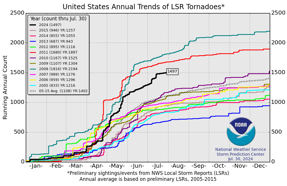
U.S. Annual Tornado Trends

A look at the chart above from the Storm Prediction Center shows the number of Local Storm Reports for tornadoes. You can click on the map to zoom in on the available years listed. But, the ones that stand out to me are the first 3 lines from the top: 2008, 2011, and 2010. These were all preliminary storm reports.

You can find the actual totals for 2008-2011 here. 
For 2011-2014 here
For 2014-the most current update here

But the years of 2008, 2011, and to some extent 2010 above are directly linked to La Nina years.

Ever since the last La Nina, the United States has recorded a less than average number of tornadoes.
But, already 2017 is starting out at a blistering pace, well above the 2005-2015 average.


And guess what? By next month, the 3-month running mean of the Oceanic Nino Index will place us in an official La Nina status. Ever since August, La Nina conditions have prevailed since ocean temperatures in the tropical Pacific have averaged at least -0.5 degrees C below the norm. It takes 5 consecutive 3-month running mean temperatures at or less than -0.5 C to upgrade from a condition to a status. Therefore, technically, we will have a La Nina status that will date back to August 2016.

For more information, I have provided a link of the ONI chart from this page.

I do believe that a very active tornado year has already commenced. As you saw from the actual tornado counts from the links above for 2008-present, several hundred tornado deaths were attributable to those La Nina years of 2008 and 2011.

There have already been tornado-related fatalities this month, a La Nina year (not officially yet). Do expect an active Spring season for severe weather.

2008 and 2011 were also characterized by an above average number of tropical cyclones in the Atlantic basin. I personally remember Hurricane Ike from 2008, a persistent cyclone that affected the United States. In fact, even after being downgraded from its tropical throne, it's original low pressure center combined with other atmospheric variables that produced destructive winds here in Kentucky. We had 70 mph winds and the sun was out. Some areas in Kentucky achieved hurricane-force winds in excess of 74 mph. Widespread tree damage and long-term power outages were the result.

 
I provided some video footage of its impacts on Louisville, KY...above.

Here is an excerpt from the NCDC Storm Data publication....
 
The remnants of Hurricane Ike moved across the Ohio Valley on the morning and afternoon of September 14th. This system,

along with an upper level trough and a surface cold front approaching the region, combined to bring very strong surface wind

gusts to the area. Widespread damage occurred with measured wind gusts up to 75 mph, along with 7 known injuries and 2

fatalities across parts of central Kentucky. Seventy-five percent of all Louisville Metro electrical customers - more than

300,000 homes and businesses - lost power for up to a week due to the storm, leaving many businesses and schools closed

during the week. Statewide, nearly 600,000 customers lost power due to the storm. Cost estimates were reported at around 10

million dollars across the Commonwealth, with 4.2 million of that in the Louisville Metro area alone. 33 counties in Kentucky

were declared major disaster areas by President Bush.
 

Ironically, the Storm Data publication seems to always display an Outstanding Storm of the Month. There were none for September 2008, probably since the destructive winds were brought about by the sunshine that helped translate the winds to the surface.

Again, bottom line. I am expecting a higher than average number of hurricanes in the Atlantic basin, some of which will impact the U.S. mainland.

This could be a destructive year for severe weather. Plan accordingly, yes, be prepared. Hopefully, La Nina will be given a little more attention than the brief spat I just presented to you today.

MS


Sunday, January 22, 2017

MikJournal Monday 01/22/2017...Sunday Edition and Stats

I was walking my dog and wearing shorts Saturday evening. That is how mild it was in my neighborhood. Not too bad for the 3rd week of January.

In my forecast for January, I did highlight the 3rd week of January as being the 'thaw' period. But you know what? We have been in thaw mode for the past several days now.

After being confined to several days of below normal readings, including Arctic chill, earlier this month, we have bounced back in a large way. Temperatures for central Kentucky are now averaging between 6 and 9 degrees above normal for the month of January. That's impressive, considering that this normally is the peak period for the coldest temperatures of the winter.

Am I ready to say this could be a top ten warmest January for some of us?

Not yet. But, we still have today through Wednesday when temperatures will be averaging nearly 10 degrees above normal. That will keep most us in top ten warmest mode. How will the rest of the month fare?

For the most part, below normal temperatures will dominate the latter part of the month. However, it does not appear to be much below normal.

But here are the top ten warmest January's with the minimum entry required versus where we stand today.

Louisville....41.0 (41.0 as of today)
Lexington...40.7 (40.4 as of today)
Bowling Green 42.8 (44.3 as of today)

Is this just a regional fluke? Check out more temperature averages...

St Louis, MO (recent ice storm) 3.6 degrees above normal
Springfield, MO  5.7 degrees above normal
Chicago, IL 3.0 degrees above normal (includes a couple of zero degree mornings)
Milwaukee, WI 3.7 degrees above normal
Minneapolis, MN 1.5 degrees above normal (includes 7 mornings below zero)
Sault Ste Marie, MI  7.7 degrees above normal (and 20.7" snowfall this month so far)
Kansas City, MO  1.2 degrees above normal (includes 2 mornings at 0 or below)
Wichita, KS  2.0 degrees above normal (includes major ice storm)
Oklahoma City, OK  0.4 degrees above normal (yes, I know it doesn't sound like worth mentioning, but a morning low of -3 offset by a high of 79 just a few days later was indicative of how many swings in temperatures they received)
Little Rock, AR  4.4 degrees above normal
Huntsville, AL  11.1 degrees above normal
Chattanooga, TN  10.0 degrees above normal
Asheville, NC  7.6 degrees above normal
Harrisburg, PA 4.2 degrees above normal

I think you get the picture. Yes, we had winter in many of these places this month but was offset by a prolonged warm spell that has won out thus far.

I continue to blame the Arctic Oscillation, which has stayed neutral to positive since December. Long range forecasts keep the AO in positive territory through the first part of February.

Even though winter will make a comeback, Arctic temperatures do not look likely for the next 10-12 days. Snowfall for our region does not look promising, except the little nuisance snows that may provide some excitement based on what snows we have seen so far this winter. Believe me, it won't take much to get a back loaded winter after what we have experienced through the first half.

MS

Friday, January 20, 2017

This is January, Right?

It looks like a duck, walks like a duck, it must be a duck. It feels like March, acts like March, so it must be...what, January? Huh?

Monthly temperatures are now averaging between 5 and 7 degrees above normal. And this includes that brutal stretch of cold we experienced earlier this month.

Rainfall amounts are well above average for the month too. That would be expected since the bulk of our measurable precipitation for January should be in the form of something frozen.

I want you to keep in mind that Alaska and Kentucky are interconnected more than you think, and I don't mean sharing statehood in these United States of America.

The other day on the 18th, Fairbanks recorded a high temperature of -41 degrees after bottoming out at -51. The low temperature was not even a record, since -61 was the record.

Still, the average temperature of -46 (add the high and low, then divide by two), was some 37 degrees below normal.

Transporter...beam me to somewhere in Kentucky. Our high temperatures have been averaging 10-20 degrees above normal recently, offsetting the Arctic chill earlier.

The connection? Typically, not always, when parts of Alaska are experiencing much below normal temperatures, our temperatures will be averaging above normal plus or minus a couple of days.

Now watch what happens over the next week or two. Eventually, Alaska will be recording above average readings, and guess where that should lead us? At the very least, to conditions that resemble winter, perhaps below normal for a time.

And the month of February may be able to exceed snow totals from January. However, we still have to get through the rest of January, since the end of the month could throw some surprises our way, yet.

MS

Monday, January 16, 2017

MikJournal Monday 01/16/2017...Mid-Month Projection

Good Monday morning. Possibly you have the day off and good for you. Temperatures will be on the rise; although, for some, the highest temperatures for the day may not come until closer to midnight. Still, above normal.

Well, it has rained 6 consecutive days. During that time period, though, rainfall amounts have generally been tame. Remember last Monday in my MikJournal, I saw forecasts for 2.5 - 4.5" for the week. So, how did we do?

I took a sampling of several Mesonet sites and official observations. Generally we received 1.5 - 2.0" for the week. So, the ground was not overly saturated, and rivers and lakes were not overly high.

Our region came close to a major ice storm just west and northwest of us. The only ice accumulation I could find for the region was in far western Kentucky. Sturgis, in Union County, received about 0.1" and Carrsville, in Livingston County, received 0.05".

The latest amounts from the hard-hit areas include Missouri, Oklahoma, and Kansas, where 0.50" amounts were common across those states. Some of the leading energy providers have reported some outages, though this is not a widespread problem. This does not compare to anything our region experienced in February 2009, when many Kentucky residents did not have power for at least 4 or 5 days, some up to 2 weeks.

The forecast rainfall amounts for the week ending next Monday morning from the Weather Prediction Center is a widespread 2-3" statewide, with locally heavier amounts, especially south.

No snow or ice is expected.

Temperatures will be above average for the week. And I do mean way above average. My January prediction for below normal temperatures this month looks to be in jeopardy, thanks largely in part to the Arctic Oscillation, which stubbornly refuses to dip below the negative line. Typically, a negative AO will favor a colder climate pattern for our region. We just have not had that.

The middle of the month storm that got me excited ended up being the ice storm that hit just west of us. And the January thaw..., well, after the first stretch of brutal cold, we have been in thaw and blowtorch mode ever since.

At this time, I am projecting our region will have widespread above average temperatures for the second consecutive month of this meteorological winter. Snow chances may make a comeback by the last of the month, but right now, I am just not that impressed with the setup for colder air and snow opportunities.

The last Euro model run does show temperatures coming back down to normal or slightly below normal by the 24th. After the 26th, colder air and snow chances will be moving in. But, remember, that is still 10 days out. So far, forecasts are just not panning out. They have all trended warmer.

The AO needs to go negative. The NAO and EPO, two leading indicators are not quite aligning themselves to support snow chances for our region by the 26th.

By this time next week, I should be able to say with some certainty whether or not snow chances could be realized after the 26th. But right now, I would not expect anything more than a few flurries before then.

I am not thinking about February yet. Until I see a change in the overall pattern, a few days of cold will continue to be offset by warmer episodes. Go AO, think negative.

Have a good week.

MS

Saturday, January 14, 2017

Ice Storm in Progress

Sunday, 01/14/2017
Ice storm still in progress across central and southern plains. Most reports have come in much less than expected. Still, a lot of traffic issues and some power outages. I would say this storm system for the region was not as crippling as advertised. Generally, I have read reports of 0.1 - 0.3" ice accumulation. Once you reach 0.25", isolated power outages start to occur. However, areas that have prolonged ice accretion, I would expect the weight to negatively impact and overcome some weaker trees, which still yet may lead to additional outages. Temperatures near the freezing mark are making for less slippery travel on main area roadways. Still, elevated surfaces like overpasses and ramps may be subjected to icy conditions.

----------------------------------------------

From St Louis University...Clock tower
https://www.slu.edu/webcam/clocktower-view.php

More to be added later from Tulsa OK, Wichita KS, and others...some are expecting up to an inch of ice. How sad.

-----------------------------------------

MS

Friday, January 13, 2017

Another Warm Year for U.S.

According to the latest data, the U.S. saw its 2nd warmest year ever, just finishing behind 2012.

Georgia had its warmest year on record.

Kentucky also finished way up there in the warmest years category.

The last time the U.S. had a below average report was 1996...that's right, 20 years!

MS

Monday, January 9, 2017

MikJournal Monday 01/09/2017

Welcome to the latest edition of MikJournal Monday. Well, we got our first widespread measurable snow event of the winter season late last week into the first part of the weekend.

The seasonal regional snow totals have been updated on the blog. Keep in mind that most of the updated totals occurred during, for some, the 1-2 punch of snowfall that really overachieved for some residents of far southeast Kentucky. Snowfall amounts of 1-5" were common across the state.

The southern storm system really packed a wallop at some locations not used to the winter weather.

Here's a few locations from those reporting stations, not in any particular order....

Asheville, NC  7"
Greenville-Spartanburg, SC   4.3"
Beech Mountain, NC   9.5"
Bryson City, NC  5.6"
Forest City, NC   5.6"
Lake Lure, NC   6.0"
Marion, NC   7.0"
Marshall, NC   6.5"
Mt. Mitchell, NC  12.5"
Tryon, NC   10.5"
Knoxville, TN 4.0"
Elizabethton, TN  7.3"
Danville, VA  8.8"
Appomattox, VA  9.3"
Yadkinville, NC  8.0"

Appomattox. What a cool name for a town. Of course, Virginia is full of history, and this place played a key role in the final months of the Civil War, with General Robert E. Lee surrendering to General Grant at the famous Appomattox Court House in April 1865.

They are no stranger to winter snow, that's for sure. Last January, on the 23rd and 24th, total snowfall accumulation came in at 11.2". You think that was a lot. That same storm system affected our region with an incredible 18.5" at Jackson's Julian Carroll airport on the 22nd and 23rd. Over 22" fell near Booneville. In fact, several locations in eastern Kentucky recorded over a foot of snow. Now, that was one for the history books.

Looking ahead for what is going to happen this week. Well, warmer air is poised to move back into the region. Along with that, a trillion gallons of moisture is heading our way. Well, it's going to seem like a trillion gallons. Whatever's going on out there in California, yep, it's heading this way.

I looked at the latest QPF forecast for the next 7 days, and it shows about 2.5 - 4.5" rain could fall along the Ohio River corridor. Can you imagine how much snow that would have been if it would just stay cold enough?

Signals that seemed promising last week for more wintry weather have now shunted to the other side. More wet than white, it appears. The AO index from the GFS ensembles last week showed a nearly unanimous plunge into the negative by mid-month. However, most of them now show the AO may straddle neutral, which means more milder air hanging around than cold air hanging around.

So, it's still possible to sneak a winter weather maker somewhere in the next two weeks, but anything that falls won't stick around very long. Too many variables now pointing to above normal temperatures and precipitation for our region, at least through the 3rd week of this month. The CPC, AO index, the European Model at 6-7 days out, it just don't look good for us winter weather lovers.

I was hoping the AO index would dip into the quite negative range for a while, then trend higher. But, just barely getting into the negative and then trending higher just is not enough to convince me that a breakout snow will occur anytime soon for the area. So, hopefully, you got to enjoy what white we did have.

Here's to hoping you have a good week.

MS


Saturday, January 7, 2017

Updating Snow Totals Soon

Well, a 1-2 punch has made for a healthy dumping of snow for parts of the far southeastern counties at least.

Elsewhere, in north central and northern Kentucky, lighter amounts occurred but still counts as our first accumulating snow outside of freak freezing fog induced snow events.

I told you before the end of last year to mark down January 7, that we would be registering snowfall greater than the wimpy 0.1 - 0.2".

As the latest system pulls away, I will be updating regional snow totals and share a few totals coming in just south and east of our region...some amounts are staggering.

Also, I will be turning my attention to our next possible winter scenario, again something that I said recently in my January prediction, that could be more exciting than this past system(s).

 MS

Wednesday, January 4, 2017

Sweet Spot of the NAM Runs

Final Update for this post...
While I do not fully endorse these last runs of the NAM, that is yesterday's 0z run and today's 12z run, the idea of overachieving is out there. A consistent signal of 1-3" with possible 4" amounts, generally along and north of I-64. Of course, the uplands and mountainous terrain of eastern Kentucky could also see similar totals, but areas generally south of the Parkway will see less accumulation.
________________________

Last night's run of the NAM is the first of two runs that should give us a good indication of amounts of snowfall for the region. While individual locations may vary, I did notice that the heavier amounts have shifted north from earlier runs.

Amounts of 1.5 - 2.5" could be realized for Louisville and Lexington. That is higher than the 1" or less I was forecasting for our region. In fact, areas south of Louisville may get an inch or less instead...almost a mirror image of my previous thinking.

Hopefully, virga will not eat away at whatever precious snow that falls. That is always a bummer.

MS

Tuesday, January 3, 2017

Previewing Upcoming Snow Event(s)

We have Arctic air heading this way. It will begin arriving late tonight, becoming well entrenched by tomorrow afternoon, and then hanging out for a few days.

Snow chances will be increasing by early Thursday into the afternoon hours. I looked at analogs a couple of days ago and put out a comment that most areas of the state will get an inch or under. However, some areas to the southeast part of the state could see more. The data suggested a general 1-3" swath. This may be associated with uplift and intensifying bands. I'm still holding to that general forecast.

Additionally, SE Kentucky could be getting brushed with a stronger system by the weekend. That still remains in question, as that part of the data still needs to be fine tuned as measurements will be sampled for the storm system soon to move ashore.

Well, anyway, here's to hoping for an overachieving period of winter's best.

MS

Monday, January 2, 2017

MikJournal Monday 01/02/2017

Good morning and welcome to a new year of what I call whatever weather. Here's what to look for this week....

Storm system #1 (SSYS1) rain and thunder, decent soaking again.
Blast of modified Arctic air invades our region with snowshower activity.
SSYS2 late week winter weather potential....

The second storm system...well, you'll just have to be patient. Remember, we have to get through SSYS1 first, then see how strong the cold airmass behind it will become, and then sample the next storm system as it moves ashore, and then see what possible and more likely scenarios will take place.

A lot of moving parts will be in play. That's why all of the alphabet soup models are going to fluctuate until at least tomorrow, maybe tomorrow evening.

However, the models, analogs, and teleconnection signals are all showing something wintry will impact the region later this week. Now, how much wintry is still up in the air, no pun intended.

After that, could the cold air retreat a little bit? All of this talk about blocking along the west coast and blocking on the east coast and a bridging of the two blocks seemed like a lock for a sustained period of much below temperatures.

But, the European model shows temperatures rebounding to at least normal by this time next week. Still cold, but not icebox cold. In addition, some teleconnection signals point to a slight relaxing of the dual blocks.

Perhaps the cold air will be reloading just to our north, poised to plow in here by the middle of the month, and set the stage for a more dramatic winter scenario. That's what the AO may offer as a signal. It is predicted to go negative. I have repeatedly said to watch for an upward tick in the AO after being negative for a time. Throw a storm system in there at about the same time. There you go.

An active month indeed. Have a good and safe week everyone.

MS

Tornadoes on Easter Sunday

This is a worse case scenario. Tornadoes and flooded, blocked roadways making for great difficulties reaching residences affecting hard hit ...