Today, I wanted to talk about something that hasn't been given too much attention lately. La Nina. Some may scoff at it, because it's not as prominent as the El Nino. But, for ones who are concerned about severe weather seasons and hurricane seasons, this may be for you.
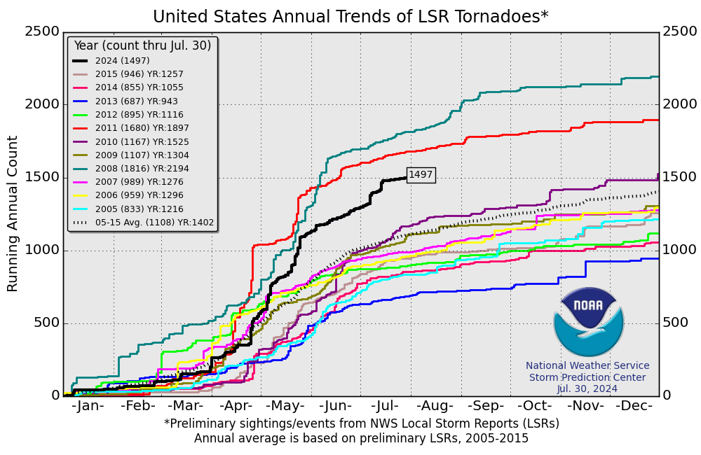
A look at the chart above from the Storm Prediction Center shows the number of Local Storm Reports for tornadoes. You can click on the map to zoom in on the available years listed. But, the ones that stand out to me are the first 3 lines from the top: 2008, 2011, and 2010. These were all preliminary storm reports.
You can find the actual totals for 2008-2011 here.
For 2011-2014 here
For 2014-the most current update here
But the years of 2008, 2011, and to some extent 2010 above are directly linked to La Nina years.
Ever since the last La Nina, the United States has recorded a less than average number of tornadoes.
But, already 2017 is starting out at a blistering pace, well above the 2005-2015 average.
And guess what? By next month, the 3-month running mean of the Oceanic Nino Index will place us in an official La Nina status. Ever since August, La Nina conditions have prevailed since ocean temperatures in the tropical Pacific have averaged at least -0.5 degrees C below the norm. It takes 5 consecutive 3-month running mean temperatures at or less than -0.5 C to upgrade from a condition to a status. Therefore, technically, we will have a La Nina status that will date back to August 2016.
For more information, I have provided a link of the ONI chart from this page.
I do believe that a very active tornado year has already commenced. As you saw from the actual tornado counts from the links above for 2008-present, several hundred tornado deaths were attributable to those La Nina years of 2008 and 2011.
There have already been tornado-related fatalities this month, a La Nina year (not officially yet). Do expect an active Spring season for severe weather.
2008 and 2011 were also characterized by an above average number of tropical cyclones in the Atlantic basin. I personally remember Hurricane Ike from 2008, a persistent cyclone that affected the United States. In fact, even after being downgraded from its tropical throne, it's original low pressure center combined with other atmospheric variables that produced destructive winds here in Kentucky. We had 70 mph winds and the sun was out. Some areas in Kentucky achieved hurricane-force winds in excess of 74 mph. Widespread tree damage and long-term power outages were the result.
Here is an excerpt from the NCDC Storm Data publication....
The remnants of Hurricane Ike moved across the Ohio Valley on the morning and afternoon of September 14th. This system,
along with an upper level trough and a surface cold front approaching the region, combined to bring very strong surface wind
gusts to the area. Widespread damage occurred with measured wind gusts up to 75 mph, along with 7 known injuries and 2
fatalities across parts of central Kentucky. Seventy-five percent of all Louisville Metro electrical customers - more than
300,000 homes and businesses - lost power for up to a week due to the storm, leaving many businesses and schools closed
during the week. Statewide, nearly 600,000 customers lost power due to the storm. Cost estimates were reported at around 10
million dollars across the Commonwealth, with 4.2 million of that in the Louisville Metro area alone. 33 counties in Kentucky
were declared major disaster areas by President Bush.
Ironically, the Storm Data publication seems to always display an Outstanding Storm of the Month. There were none for September 2008, probably since the destructive winds were brought about by the sunshine that helped translate the winds to the surface.
Again, bottom line. I am expecting a higher than average number of hurricanes in the Atlantic basin, some of which will impact the U.S. mainland.
This could be a destructive year for severe weather. Plan accordingly, yes, be prepared. Hopefully, La Nina will be given a little more attention than the brief spat I just presented to you today.
MS


No comments:
Post a Comment