
Kentucky
|
| Total Reports = 4 |
| Tornadoes = 1 |
| Hail Reports = 1 |
| Wind Reports = 2 The above map for Kentucky represents preliminary reports of severe weather received so far through February 11. As you can see, a tornado report was received on February 7 in western Kentucky near Cadiz in Trigg County. According to the Paducah NWS, it was confirmed that an EF-0 tornado caused some damage mainly to trees near the Cadiz area. Some barns were also impacted. In addition, quarter-size to golf-ball size hail was reported in and around the same area. I am providing a link from the NWS. Click here. Nationally, the tornado count is way above average. It's still early, but I have been anticipating an active severe weather calendar year. In fact, if you look at the chart below, you will notice that we are already on track to record the most tornadoes since 2008, possibly eclipsing 2011's reports. 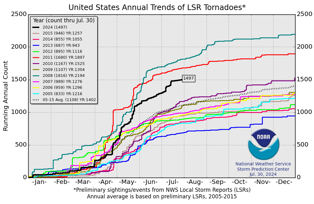 So far this month, I have not read of any fatalities associated with the 20 or so tornado reports, but there have been many injuries, last count was about 36. Spring seems to be starting earlier this year. Although I am not counting out Winter just yet, the unseasonable warmth will continue to battle with Winter's last gasps leading to severe weather events. This is now the 2nd time this year I have mentioned the threat for an active severe weather year. Where most of the severe weather will happen nobody knows. But, even California is getting more severe weather reports than usual. Western Kentucky has already recorded a confirmed tornado. Be prepared. A weather radio is recommended. Keep an eye to the sky. Take an online class or attend one of the Spotter classes to help the NWS know what's happening based on your report from your location. Of course, safety is paramount. Never place yourself directly in harm's way. While it's nice to get the 'picture' or 'video', immediate relay of information is essential for the NWS to issue statements for adjoining locations in the path of any dangerous storm. I have been doing this for several years. I have great respect for lightning and high winds. Perhaps it's my age, but my daring adventures of long ago have transitioned to getting reports out as soon as it is safe to do so and communications equipment have not been damaged or disrupted. Have a safe year, everyone. MS |


No comments:
Post a Comment