As far as the contiguous United States are concerned, the year 2015 was the 2nd warmest on record, second only to the year 2012. We have had 19 consecutive years of above average temperatures. 1996 marks the last time we had below average temperatures nationwide.
It was the warmest Autumn on record for the continental U.S. In addition, December was the warmest month on record
It was also the 3rd wettest year on record, with 1973 and 1983 wetter, they too strong El Nino years.
I am sure to dredge up more statistics when I can. Also, I plan to reveal the global climate situation in a future post.
MS
Tuesday, January 26, 2016
Monday, January 25, 2016
MikJournal Monday 01/25/16
Well, I had 7.5" snow last week at the house here in Valley Station. It looks a lot like it did back in March when I shoveled out my driveway in the front and back of the house.
I also tied my lowest temperature for the season at 9 degrees yesterday morning, thanks in part to the existing snowpack.
However, the snowpack is dwindling as sunshine has been eroding the stockpile. I started yesterday at about 4-5"; now, it's down to 2-3".
But, it was fun while it lasted. I took my little girl sled riding at a nearby Metro Parks approved location for such an event. The hills were steep and fast. Lots of broken plastic sleds were sprawled about the area. Of course, that was most likely the result of drop-offs when one would gather lots of speed down the hill and suddenly you were airborne for a moment before crashing back to the packed surface and continue downhill. Needless to say, our plastic sled performed much better than others' and remained in one piece.
I have read the reports of others in the region. Some of you have had between 1 and 2 feet of snow, mainly over the first part of the weekend. For snow lovers, it was a dream come true.
Then again, even the snow lovers had to contend with just trying to get out of the house as snow drifts no doubt piled against some of your front or back porches. Perhaps you were one of the unfortunate ones who were stranded along a stretch of I-75 Friday night for hours while snow pummeled your location. Or, enduring hours of having no power proved quite disheartening for some. Why, travel in general was pretty hard to do even if you could get out of the driveway to enjoy the sites of your winter wonderland.
We weren't the only ones who had the snow in the region. While the entire state of Kentucky had some measurable snow during the past week, the Midwest sector, which we are a part of, peaked at nearly 80% coverage on January 22.
In fact all of the NWS official locations that include Paducah, Bowling Green, Lexington, Louisville, and Jackson have above average snowfall now for this time of the year.
Surprisingly, many mountainous regions and favored locations along the Great Lakes have seen below average snowfall for the season.
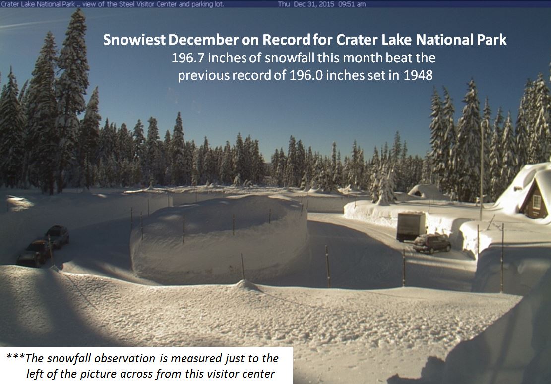
But, Crater Lake National Park out in Oregon is above average. After a record-setting December, this month has been an above average one as well. They have now tipped the scales at over 300" since the season began.
On the other hand, Mount Washington NH, home of the world's worst weather, has had below average snowfall. As I write this, only 85.0" has accumulated so far this season. A normal snow season is about 281". Of course, we still have a ways to go as February and March are typically snowy as well. And April is somewhat productive too.
I will say this though about Mount Washington. On January 19, the daytime high was -9 and the low temperature was -22. Winds gusted to 127 mph at the top of the 6,280 ft summit. The average temperature being -15 and the average wind speed at 86 mph produced an average wind chill of -60! Can you say ouch??
Looking ahead, the weather will be turning warmer as the AO which has been trending toward neutral should become positive for a brief time. Recall that I mentioned something about a transition, going from a negative state to a positive one can have exciting consequences for fans of winter weather. Well, you just got your reward. Now, the January Thaw will commence for a time before the next change or transition takes place.
It has something to do with the Polar Vortex. Ah, the infamous Polar Vortex. I can see it now. Hollywood is probably already coming up with a script where a fat man in a red suit is storm chasing and comes upon an abominable snowman-looking tornado near his home at the North Pole, doing everything he can to rescue his family and workers before disaster strikes, since they have poor cell phone reception and no outdoor sirens to alert the public for life-threatening weather emergencies.
Anyway, it will be turning much colder as we get into the month of February. My February prediction comes out later this week.
MS
I also tied my lowest temperature for the season at 9 degrees yesterday morning, thanks in part to the existing snowpack.
However, the snowpack is dwindling as sunshine has been eroding the stockpile. I started yesterday at about 4-5"; now, it's down to 2-3".
But, it was fun while it lasted. I took my little girl sled riding at a nearby Metro Parks approved location for such an event. The hills were steep and fast. Lots of broken plastic sleds were sprawled about the area. Of course, that was most likely the result of drop-offs when one would gather lots of speed down the hill and suddenly you were airborne for a moment before crashing back to the packed surface and continue downhill. Needless to say, our plastic sled performed much better than others' and remained in one piece.
I have read the reports of others in the region. Some of you have had between 1 and 2 feet of snow, mainly over the first part of the weekend. For snow lovers, it was a dream come true.
Then again, even the snow lovers had to contend with just trying to get out of the house as snow drifts no doubt piled against some of your front or back porches. Perhaps you were one of the unfortunate ones who were stranded along a stretch of I-75 Friday night for hours while snow pummeled your location. Or, enduring hours of having no power proved quite disheartening for some. Why, travel in general was pretty hard to do even if you could get out of the driveway to enjoy the sites of your winter wonderland.
We weren't the only ones who had the snow in the region. While the entire state of Kentucky had some measurable snow during the past week, the Midwest sector, which we are a part of, peaked at nearly 80% coverage on January 22.
In fact all of the NWS official locations that include Paducah, Bowling Green, Lexington, Louisville, and Jackson have above average snowfall now for this time of the year.
Surprisingly, many mountainous regions and favored locations along the Great Lakes have seen below average snowfall for the season.
But, Crater Lake National Park out in Oregon is above average. After a record-setting December, this month has been an above average one as well. They have now tipped the scales at over 300" since the season began.
On the other hand, Mount Washington NH, home of the world's worst weather, has had below average snowfall. As I write this, only 85.0" has accumulated so far this season. A normal snow season is about 281". Of course, we still have a ways to go as February and March are typically snowy as well. And April is somewhat productive too.
I will say this though about Mount Washington. On January 19, the daytime high was -9 and the low temperature was -22. Winds gusted to 127 mph at the top of the 6,280 ft summit. The average temperature being -15 and the average wind speed at 86 mph produced an average wind chill of -60! Can you say ouch??
Looking ahead, the weather will be turning warmer as the AO which has been trending toward neutral should become positive for a brief time. Recall that I mentioned something about a transition, going from a negative state to a positive one can have exciting consequences for fans of winter weather. Well, you just got your reward. Now, the January Thaw will commence for a time before the next change or transition takes place.
It has something to do with the Polar Vortex. Ah, the infamous Polar Vortex. I can see it now. Hollywood is probably already coming up with a script where a fat man in a red suit is storm chasing and comes upon an abominable snowman-looking tornado near his home at the North Pole, doing everything he can to rescue his family and workers before disaster strikes, since they have poor cell phone reception and no outdoor sirens to alert the public for life-threatening weather emergencies.
Anyway, it will be turning much colder as we get into the month of February. My February prediction comes out later this week.
MS
Saturday, January 23, 2016
After the Storm...01/22/16
Well, Kentucky's winter storm is still ongoing but winding down for many. Lots of double-digit snowfall amounts have been received, especially from central into eastern parts of the state.
Jackson KY surpasses the January 1996 snowstorm and eventual blizzard for 2-day snowfall record at 16.2". Remember, the January 1996 blizzard kept showing up in top analogs for this storm system. The awesome 1993 storm of March was the only other time period that outshone this current event. Records date back to 1981.
I have read amounts of 18-19". Wow! Some parts of far eastern Kentucky may still get additional accumulations adding to some who already have double-digit totals.
Bowling Green's 12.2" yesterday obviously set a daily record, but also goes into the record books as the 3rd snowiest day ever for any month and the snowiest January day on record. In addition, the monthly total of 14.8" now ranks as the 6th snowiest month of January.
A massive traffic snarl on I-75 stranded thousands for a time after a series of crashes led to both sides of the interstate to be closed.
Also, power outages became issues for some residents in Knox, Whitley, and Pulaski counties. Each of their electric cooperatives were working to restore power to these residents still as of early this morning.
MS
Thursday, January 21, 2016
NOWCAST II For Possibly Crippling Snow
Well, don't I sound like a doomsday prophet? I typically try and control my emotions when it comes to a significant weather happening. However, this storm looks to rank among the likes of last March here in Kentucky. In addition, it could potentially become a powerful blizzard, similar to the Blizzard of 1996 for the Eastern seaboard.
Shutdown snowfall looks to be a strong possibility for many along the East coast, and the potential for major power outages across parts of Virginia and the Carolinas from a serious ice storm.
This weather system is so formidable that for the first time I have seen, a live press conference was carried out on one of my local media outlets with representatives from the Public Works department for road crews, the NWS , and Jefferson County Public Schools convening to discuss the impending storm.
After 4:00a.m., I will be posting any significant changes to possible amounts from NWS and local media as well as my thoughts here below....
----------------------------
5:25am
Louisville forecast is now solidly 6-8" for most. Slightly lower in far north part of the county and perhaps 8+" out where I live in SW Jefferson
Snow reported near Sonora along I-65.
------------------
9:20am
Welcome to the MikJournal Doughnut Hole capital of Louisville. Finally, the radar surrendered a few flakes at 9:05.
--------------
9:25am
I did notice that NWS Louisville lowered Louisville's overall totals by about an inch...3-7"
I am still expecting at least 7" at my location in Valley Station.
---------------
9:50am
4" now reported in West Paducah, Madisonville, and Cadiz
4" also in Paint Lick and Campbellsville
4.5" near Bowling Green
----------------
11:30am
A lull in the activity here at the house...just measured 1.3". I was projecting 3" at the house by noon. With heavier snow still pretty far south of my area, I'll be a bit shy of the 7" total I was expecting at the house.
---------------
12:15pm
Some area snowfall reports as of noon
8" - Hobson (Taylor County)
7-8" - Bowling Green
6" - Liberty
6" - Berea
5" - Lancaster (Lincoln County)
---------------------
12:55pm
Closing in on 2" in Valley Station...on track for 5-6" here unless we get in on overachieving bands.
--------------------
1:05pm
Latest HRRR has Louisville in a 3-6" total
----------
2:10pm
Heavier bands increasing along Ohio River, beginning to show signs of a deformation...this could become our most productive accumulation over the next couple of hours. Could see 2 more inches at least.
-----------
2:15pm
Snowfall amount at my house stood at 2.0" but a deformation band of increasingly heavier amounts may end up doubling this total in the next few hours.
------------
2:30pm
Additional snow amounts for some of us to covet...
Lebanon...12"
Bonnieville...11"
Greensburg...9"
---------
7:10pm
Snow is winding down here at my house...yes, somewhat disappointing but I did record more snow this time than with system #1, which had 3.5"
My total so far and we probably won't get much more is....3.8"
----------------
9:10pm
Final update....
Power outages have become a problem for some residents due to the storm system
My total was 4.0"
MikJournal Call for Snowfall...System II
Here goes it....
Louisville....4-9"
Mount Washington....7-11"
Bardstown...6-12"
Lexington....5-10"
E'town...6-12"
Richmond...6-12"
Morehead...5-10"
London...8-16"
I will say that the highest amounts do face a certain amount of uncertainty, as sleet or rain may interfere with snow totals.
My confidence in the above forecast is medium, definitely not high. And I chose only a few locations because I already have a headache just from these locations above.
MS
System 2 to Make a Fool of Us Too
Well, I said that I would wait until this morning's run of the NAM before issuing my snowfall forecast. And I am, reluctantly.
I am trying to come up with a sensible forecast, but my typical confidence in the NAM does not meet criteria for disseminating amounts that I feel comfortable with.
Nevertheless, I will have amounts posted by noon today for central and east Kentucky.
Again, let me emphasize that this will not be an easy forecast, I don't care how confident even the professional Mets feel.
So many dynamics that hopefully, the short term models will make sense of it. Right now, central Kentucky appears to be the bullseye, but this will also be the area that a mix could alter totals significantly.
Check back after 12:00 today for my call for snowfall.
MS
Wednesday, January 20, 2016
The Blizzard of 1996...Could System #2 Become a Copycat?
In lieu of the impending winter storm coming up in less than 48 hours, I have noticed that the American models have now both highlighted the 'Blizzard of 1996' as their #2 analog. Some of the expectations are eerily similar to the event that occurred nearly 20 years ago.
Here's an excerpt from Central Kentucky in the National Climatic Data Center's Storm Data publication...with apologies on the alignment of the text below.
freezing rain initially fell in Bell and Harlan Counties, total amounts averaged between 6 and 14 inches.
And from Northern Kentucky....
Blizzard of '78.
Thanks again to the NCDC Storm Data Publication for the January 1996 report.
MS
Here's an excerpt from Central Kentucky in the National Climatic Data Center's Storm Data publication...with apologies on the alignment of the text below.
A major snow storm hit Kentucky on January 6-7, 1996. The snow began around noon est and effected all of the counties in the
Louisville CWA before it stopped Sunday afternoon. The heavy snow began around 1500 est on the 6th and ended around 6 am est
on the 7th. A strong double-barreled low pressure system moved from the Gulf states on the 6th to Georgia and then the South
Carolina coast by the afternoon of the 7th. The snow became light and moved East of the CWA by 0000 est on the 8th. Between 2
and 6 inches of snow fell across the CWA by 2030 est. Meade, Breckinridge, Larue, Bullitt and Hardin Counties all reported up to
6 inches across their respective counties, while Spencer County led the way with 7 inches of accumulation. By 0200 est, between 5
and 12 inch total accumulations were reported. Green and Laurel counties had 12 inches. By 0600 est on the 7th, totals were from
6 inches at several locations to 16 inches in Laurel County. Totals were from 7 to 12 inches across east central Kentucky to 7 to 16
inches across south central Kentucky to 6 to 12 inches across north central Kentucky. Little additional snow was reported after
0600 est. Laurel County still led the way with 16 inches in spots.
Also, from Eastern Kentucky....
A major winter storm brought heavy snow to all of southeast Kentucky. By noon EST on the 6th, 3 to 5 inches of snow had fallen
across the region. Heavier snow began around 1500 EST on the 6th, when 5 to 6 inches were on the ground. Amateur radio
operators reported 9 inches across much of southeast Kentucky at 2100 EST, and 10 to 11 inches by 2300 EST. By 1100 EST on
the 7th, 14 to 16 inch amounts were common, with 15 to 17 inches covering much of the area by 1300 EST. Total snowfall
reported at 1645 EST on the 7th averaged between 14 and 22 inches, with the heaviest amounts in Pike County. Where rain and
The Blizzard of '96 developed near the Gulf Coast and moved up the East Coast. This massive system brought the greatest
snowfall from one storm to Greater Cincinnati/Northern Kentucky airport, as well as the greatest 24 hour snowfall. Total snowfall
from this storm at the airport was 14.3 inches, while in a typical entire season this location normally receives only 23 inches of
snowfall. Many homes and business experienced partial or total roof collapses due to the weight of the snow. Road conditions
remained hazardous in some locations for many days. Many people believed that this was the worst winter storm since the
Blizzard of '78.
Thanks again to the NCDC Storm Data Publication for the January 1996 report.
MS
Subscribe to:
Posts (Atom)
-
Recently, I noticed that our days have now begun to shorten. However, our sunset here in Louisville still remains at 9:10pm edt. Starting th...
-
 In July of this year, I did a segment about the latest sunsets in the eastern time zone. This corresponded nicely with the summer solstice a...
 -
A 1 Temperature C Humidity F Heat Index 2 81 82 86.82 This is an Excel spreadsheet program. Fairly ...
