Irene still at 115 mph
Speeding up...12 mph NW
956mb and falling, means intensification likely
In fact, expected to be Cat-4 within the next 24-36 hours.
Some weakening expected when it approaches US coastline.
Forecasts keep Irene offshore of US mainland.
Updated forecast below...
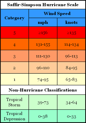
As of this morning, Irene has now been classified as a major hurricane with sustained winds estimated at least 111 mph for major hurricane status. The official estimate is 115 mph for this report.
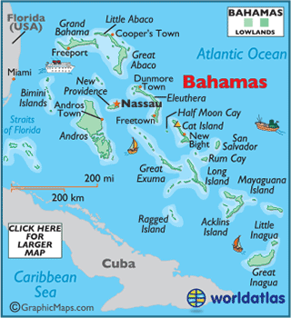
At 11:00am edt, I have the latest coordinates pegged at 22.4N by 73.9W. It is passing by the Acklins Island at this time. The next islands that will be grossly impacted appears to be San Salvador Island and Cat Island. I say 'grossly' because several of the islands are experiencing at least tropical storm force winds.
The center of Irene is moving along a trajectory that will put it between San Salvador island and Cat Island, favoring San Salvador island and nearby Rum Cay
Irene is located...as of 11:00 am edt
about 120 miles sse of San Salvador island
about 110 miles se of Rum Cay
about 175 miles se of Cat Island
At the current speed and allowing for some fluctuation in forward speed, Irene's eye should be located near or just west of San Salvador island in the next 10-14 hours from the 11:00 am reference location.
MS


No comments:
Post a Comment