Despite the impractical side of forecasting a 3-4 month range of weather when no meteorologists can accurately forecast two weeks out, a monthly outlook can offer a more realistic and hopefully more accurate presentation despite its shortcomings or limitations.
Here's what we know. El Nino conditions are present. Often, this tropical feature found way out in the Pacific helps drive weather patterns, yes even here in the United States. But, we also have to remember that other atmospheric contributors can have more influence.
But, what we don't know is which atmospheric contributor(s) will weigh more heavily on our regional weather patterns?
I am going to post a teleconnections page here. Now, this will change nearly daily. But, pay special attention to the PNA, NAO, and the EPO....

I have heard it said that we need a PNA+, NAO-, EPO-, and an AO-, which I'll get to in just a moment, for a reasonable shot at a potent winter storm for our region.
Personally, in my observations, I prefer to see a PNA+ trending negative, NAO- trending positive, EPO- trending positive, and an AO- trending positive.
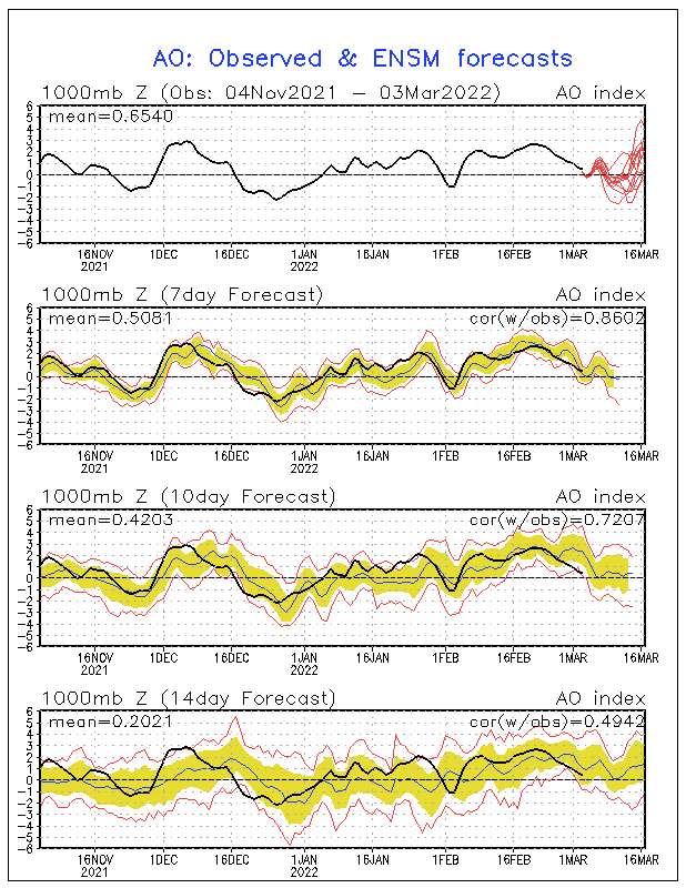
The chart above presents the mid-range players. They are still important. But, one of the main drivers of our winter patterns is the Arctic Oscillation. Here is a source that gives us an outlook for that one....

Enlarge the chart if necessary, but look at the top part of the chart, the red lines are the forecast. I like to see an AO-. Also, what I have noticed in recent years is a definitive V-shape becomes apparent that is a good indicator for winter storm/precipitation potential, one that is potentially more significant than a northwest flow of snow showers/flurries.
Look at the right side of the V. The AO should reach its most negative point (the bottom of the V), then trend toward neutral or positive. Allowing a few days or so, the cold air in place regionally should begin to have moisture entrained within the main flow, usually tapping into Pacific/Gulf of Mexico moisture. That is a good sign for a potential winter storm for our region.
However, I would still like to see the other players align a little better. As I write this, the AO is on board for a significant winter storm, but there is still alignment issues with the NAO and the EPO. These are not major alignment issues. That tells me that a part of our region may still be affected by the upcoming weather system with wintry consequences. There is still time for these issues to work out.
Looking ahead, the weather should begin to normalize toward mid-month. However, as has been the case recently, a reloading of cold air will commence and likely plunge into the region sometime after this. During the holiday week, temperatures may try to recover again with precipitation chances being introduced. Could there be snow chances? It's looking like a possibility.
Normal to below normal temperatures to end the last week of the year looks like a possibility. More precipitation chances too. But, this time it looks like a wet solution than a white one. Let's see how it works out.
MS

No comments:
Post a Comment