Good Monday morning. October, one of my favorite months of the year has arrived. And, we have pretty nice weather days ahead. Louisville's average high and low temperatures start out at 75/54 and ends the month with an average high/low of 65/45. Daylight hours continue to dwindle, starting out the month at 7:39 am sunrise and 7:25 pm sunset (11 hours and 46 minutes) on the 1st and ends the month at 8:08 am sunrise and 6:44 pm sunset (10 hours and 36 minutes), a loss for the month of 1 hour and 10 minutes. Don't worry. Daylight savings time does not end until the first weekend in November. The last day will be Saturday, November 4th. Then, turn your clocks back that night for the hour of sleep you lost during the Spring. Already feeling better, aren't you?
I have been following this story for well over a month now. But, it looks like Houston may make another run at its all-time precipitation record as early as this week. I am glad to see the NWS Houston/Galveston put out a graphic showing the wettest years ever at its official site (which has changed locations throughout the years).
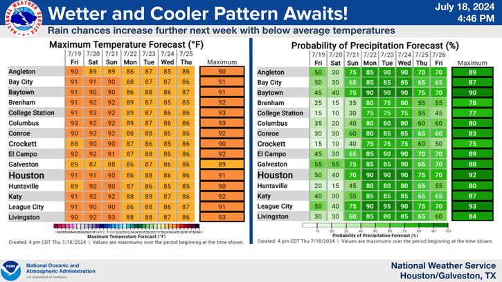
After recording only 1.23" for the month of September (a welcome reprieve indeed), rain chances are on the increase through midweek, and this includes the Houston area. So far, it appears the heaviest rainfall should materialize along the coastal areas. By the way, the official location at IAH (Bush Intercontinental Airport Houston) is located about 20 miles north of the downtown area. Lesser rain amounts? We'll see.
Not much worry here for heavy rainfall, at least according to the Climate Prediction Center. As of September 30, they issued their final October outlook and say that the month should be warmer than average and drier than average for Kentucky.
Perhaps with several clear nights ahead, take advantage of the often crisp air, making for excellent stargazing conditions. In fact, a series of meteor showers will be on display over the next few months. Here is a calendar of the more popular ones for viewing....
October 7-8...Draconids
October 21...Orionids
November 4-5...South Taurids (bright moon may impact viewing)
November 11-12...North Taurids
November 17-18...Leonids
December 13-14...Geminids
I have personally enjoyed the Orionids, Leonids, and the Geminids in years past.
Recently, I reviewed some statistics for the past month and found something I never really took notice of before, average wind speed at select locations here in Kentucky.
Here are a couple of examples. Paintsville and Jackson in eastern Kentucky barely averaged about 1 mph last month. I thought this was a fluke; therefore, I checked other months during the year. Generally, average wind speeds stayed below 6 mph, even during the windier months of January, March, and April.
Even in Harlan County, at a Kentucky Mesoset site with an elevation of 4,031 feet, the average wind speed last month was around 5.4 mph.
Louisville actually recorded an average wind speed of 10.3 mph for the month of March 2017. That was probably a little too windy for kite flying. Of course, there is not any mountainous terrain to help cut down on the flow of wind such as in the eastern part of the state.
Finally, no doubt our hearts continue to go out to our friends in Puerto Rico, as the aftermath of Hurricane Maria continues to unfold. Communications and transportation infrastructure or lack thereof has really hampered efforts to get the needed supplies to where they need to go.
Of course, Puerto Rico is no stranger to tropical systems. Perhaps some residents will remember a tropical storm called Isabel in 1985 that affected the island during early October. In fact, on the 7th, a 24-hour precipitation record of 23.75" was observed near the Tora Negro Forest. Much of Puerto Rico was affected by Isabel, and the resulting flash floods and mud slides contributed to the deaths of some 180 persons.
I will be paying attention to the tropics during the upcoming week. I have a camping trip to Myrtle Beach planned later this weekend. And it's not looking good....
Enjoy your week. I'll catch up to you later.
MS


No comments:
Post a Comment