Dare I say I might be making projections for the temperatures of September? This should have been a slam dunk for below normal temperatures this month, after the 2 weeks of 'ahhh' weather we enjoyed earlier this month. But now...?
It's going to be that close. Quite likely, I will be making a midweek post with projections about whether we will be below, at, or above normal for the month.
Just a preliminary look, and again, this is not my official projection yet, but this could be how it plays out for the rest of the month...
Remember, all of this could change, because there is a cold core of air that will be positioned just to our west, but it seems that the NWS Louisville is not taking this into consideration yet.
Looking at a normal month in Louisville of 71.0 degrees for the entire month of September, we would need a total (high and low combined) of 4,260 degrees. Right now, we have achieved a total of 3,404 degrees, leaving us with a total combined high and low temperature of 856 degrees to go for the rest of the month just to achieve normalcy.
The official forecast for Standiford Field is for a total of 858 degrees, which by definition would make it an above normal month. However, once all of the averages are taken into consideration and subsequent rounding, it may just become a normal month.
Following the same pattern but for Lexington, I achieved a similar result, an above normal month by definition, but after averaging and rounding, just a normal month.
So, that will be interesting to see how it unfolds.
Now, a review of this past summer. Regionally, I already kind of hashed the numbers out in an earlier post. But, most of the region saw a below normal summer for June-August. Nationally, how did we do?
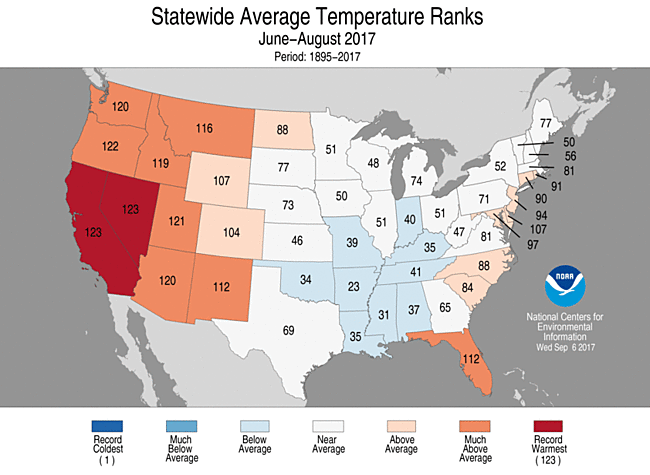
While Kentucky was accompanied by several states of the mid and deep south for a below normal summer, Nevada and California saw their warmest summer on record. Oregon almost achieved their warmest summer.
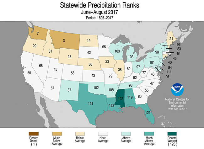
Montana had its 2nd driest summer on record and is in the grips of an impressive drought. Mississippi had its wettest summer ever, while Florida and Louisiana had their 2nd wettest summer on record.
In fact, Naples in Florida has already seen its wettest year on record, and that is with incomplete data from earlier this month.
Globally, could the string of year after year warmest land and sea temperatures be coming to an end? It's possible. Projections (not mine this time) are for 2017 to be the 3rd warmest on record when combining the land and ocean surface temperatures.
So, keep an eye for that midweek post. Hopefully, I'll have updated information whether there will be a more pronounced cooling trend coming up or not.
Otherwise, make it a good week.
MS
No comments:
Post a Comment