Brief Update on wildfire...7:55pm edt
According to 10news.com, "The California Highway Patrol reported on its website that a Toyota Camry hit a pole and caught fire about 10:30 a.m. near the intersection of Pala Temecula and Moro roads, but the official cause of the wildfire remained under investigation."
Been following a 300-acre brush fire in San Diego county at Pala Temecula Rd.
Evacuation advisories are under way as some homes are being threatened in the Pala, CA area.
Updates can be found here.
I've been following the action on the police scanner channel here.
MS
Monday, August 29, 2011
Caught On Tape...
This one will make the 'stupid criminals' list...
Click HERE.
Burglary suspects caught in the act while LIVE TV report in progress.
MS
Click HERE.
Burglary suspects caught in the act while LIVE TV report in progress.
MS
Doomed Sailboat In Irene's Fury
Check out this video link of a sailboat caught in Irene's fury...
http://www.youtube.com/watch?v=skxOyyYReQk
There were two people that had to be rescued.
MS
http://www.youtube.com/watch?v=skxOyyYReQk
There were two people that had to be rescued.
MS
Babies Born During Storm Have Been Named Irene
Despite the violent, unpredictable weather raging along the Carolina coast, two girls that were born during hurricane Irene have been named after the hurricane.

How fitting the scene above since Irene's name means "peace".
If you wish to read the article, click HERE.
MS

How fitting the scene above since Irene's name means "peace".
If you wish to read the article, click HERE.
MS
North Carolina Drought and Hurricane Update...
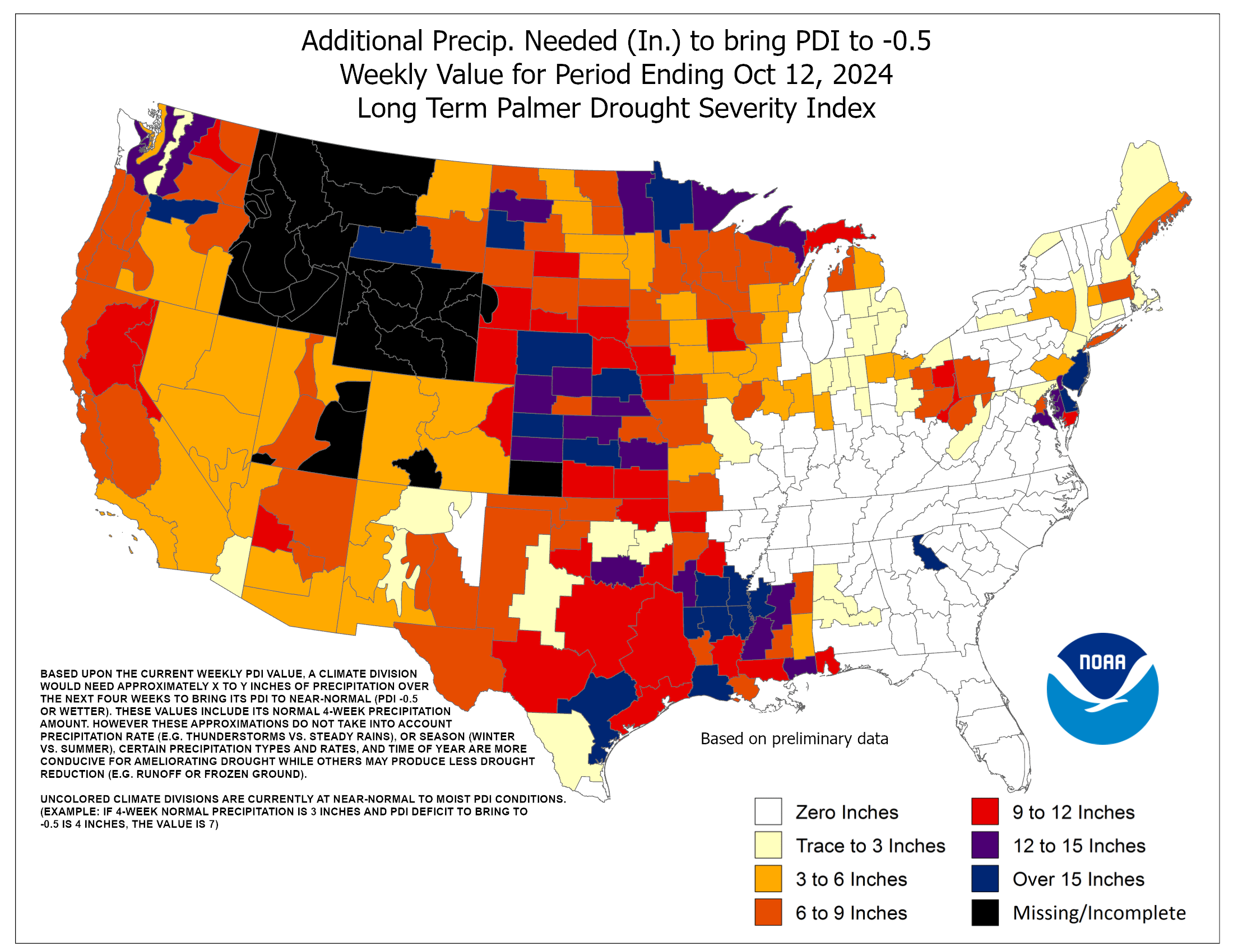
I'll be posting rainfall amounts for parts of NC over the weekend in a minute; however, take a look at last week's Drought Monitor Index for the Carolinas.
The map below shows what would have been needed to relieve the drought conditions to near normal...
Click on the map and take a closer look at North Carolina. Some places needed over 15" of rain to alleviate the current drought.
Next, take a look at Irene's wind effects for North Carolina...
Enlarge the map if needed by clicking on it. Impressive winds indeed.
Now, for the weekend rainfall amounts for selected locations across North Carolina...
Raleigh-Durham 0.54"
Beaufort 6.25"
Wilmington 6.65"
Cape Hatteras 6.71"
New Bern 7.79"
Greenville 11.72"
MS
Without a doubt, this will help alleviate some of those conditions...I know always the optimist, looking at the bright side of things after the ordeal the residents were and are experiencing there.

Click on the map and take a closer look at North Carolina. Some places needed over 15" of rain to alleviate the current drought.
Next, take a look at Irene's wind effects for North Carolina...
Enlarge the map if needed by clicking on it. Impressive winds indeed.
Now, for the weekend rainfall amounts for selected locations across North Carolina...
Raleigh-Durham 0.54"
Beaufort 6.25"
Wilmington 6.65"
Cape Hatteras 6.71"
New Bern 7.79"
Greenville 11.72"
MS
Looking Ahead to September...
Here's a look at what the Climate Prediction Center (CPC) is saying for September...
The map above shows the 6-10 day outlook
Next, take a look at the 8-14 day outlook
As of the Aug 28 report, temps are expected to be below normal for the period Sep 5 - 11.
For the month of September, we're expecting near equal chances for temps and precip to be above normal, below normal, or normal...In other words, just flip a 3-sided coin.
However, the latest update has not been published. Last update was August 18. I'll post that as soon as it becomes available.
MS
Sunday, August 28, 2011
The Big Apple vs The Coast Wrecker
8:15am
Continue to follow updates at NBC-4 New York. Good coverage there. High tide is occurring.
Just watched Cantore on the Weather Channel. I like Jim, love his enthusiasm. It always seems as if he's at the center of the worst weather. This time, however, it almost seemed like he was complaining that the storm was much stronger across the Outer Banks of NC than where he is along Battery Park in lower Manhattan. I had predicted a few days ago that winds should peak out at 60-70 mph there. Conditions are still bad in NY, but not nearly as bad as some were predicting.
Nevertheless, I defend the evacuation orders because if no orders were given and serious flooding occurred along with loss of life, then people would be 'up in arms' over that 'horrible' decision not to evacuate. But, it goes to show you can't please everyone. Some are going to look back on this and question whether they should heed the next evac order, should one occur again.
---------------------
6:55am UPDATE
22 ft waves being reported at bouys offshore.
Eye should move between Brooklyn and Queens, bringing storm surge along with an approaching astronomical high tide.
67 mph wind gust at LaGuardia
-----------------
6:45am UPDATE
Power outage updates
213,000 PSG&E
208,000 along Long Island
68,000 ConEd
As of this post, Manhattan has zero power outages, thanks to underground wires. But, that could change.
Expecting 5-7 days before power could be restored in many locations according to PSG&E
-------------------------
6:30am UPDATE
High tide expected around 8:00am
Irene moving a little faster thus coinciding storm surge and high tide; could be major flooding.
5-10" rain expected.
-------------------------
6:15am UPDATE
Now tuned in to NBC station in NY...
Death toll up to 10 along east coast of US
Roof partially torn of NJ apartment.
More updates LIVE coverage at Channel 4 HERE
Police now say a river is about to flood highway in New York city, wants to shut it down...more on this as info becomes available.
---------------
6:00 am UPDATE
Listening to Suffolk county Police scanner on Long Island...
Many fire hazards as trees are bringing down live power lines, transformer fires as well.
Roads are flooding.
---------------------------
Sounds like a Godzilla movie...but this is really serious. As of 5:40am, waking up to over 2,500,000 power outages along the east coast of the U.S.
Power outages are rapidly increasing in the boroughs of New York City. Listening to police scanners, several trees blocking highways, falling on apartment dwellings trapping residents, and downing power lines.
The LIE has a tree blocking right side of roadway.
Near the entrance to the Bronx Zoo, tree blocking both sides of the highway.
Fire Depts are very busy this morning, responding to several fires, mostly weather-related.
Wires down near E. 18th.
Subscribe to:
Posts (Atom)
Tornadoes on Easter Sunday
This is a worse case scenario. Tornadoes and flooded, blocked roadways making for great difficulties reaching residences affecting hard hit ...
-
Recently, I noticed that our days have now begun to shorten. However, our sunset here in Louisville still remains at 9:10pm edt. Starting th...
-
In July of this year, I did a segment about the latest sunsets in the eastern time zone. This corresponded nicely with the summer solstice a...
-
A 1 Temperature C Humidity F Heat Index 2 81 82 86.82 This is an Excel spreadsheet program. Fairly ...


