The latest GFS is out and its complete suite of data for this upcoming weekend, or should I say early next week?
While it seems the GFS has taken a verbal assault as of late, because of its crack-like mood swings, I thought the GFS was the first one to suggest a warmer solution to this week's storm system (the current storm system). And this was several days out. I have the maps to prove it. While not consistent in its presentation, the main thought was rain, not snow.
Can 'lightning strike twice in the same place'? Well, let's see what the latest run suggests. As you'll notice, the presentation of its solution is a bit later than the GEM or the latest Euro that I'll show you in a bit.
Looks like a light precipitation event according to this run. However, I would start paying more attention to this model in another 24 hours as the GFS should start figuring this one out, at least the idea, by then.
Again, here's the precip type below...showing mostly rain, as expected.
And of course, those critical temperatures...
As in my previous post, the temperature map shows Celsius readings, but we are solidly in the shading that denotes above freezing temperatures during the storm event thus rain.
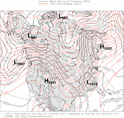
Last, the Euro shows a more wintry setup. However, even this model suggests a rain event primarily. With rain changing over to snow eventually, or possibly, could be interesting to see if the cold air can catch up with the moisture in eastern KY and wring out a couple of inches or not.
Therefore, I'm still not impressed by any of the models yet but do feel confident that these models will start coming to some type of agreement within the next 24 hours or so.
MS
Subscribe to:
Post Comments (Atom)
Tornadoes on Easter Sunday
This is a worse case scenario. Tornadoes and flooded, blocked roadways making for great difficulties reaching residences affecting hard hit ...
-
Recently, I noticed that our days have now begun to shorten. However, our sunset here in Louisville still remains at 9:10pm edt. Starting th...
-
In July of this year, I did a segment about the latest sunsets in the eastern time zone. This corresponded nicely with the summer solstice a...
-
A 1 Temperature C Humidity F Heat Index 2 81 82 86.82 This is an Excel spreadsheet program. Fairly ...


No comments:
Post a Comment