Welcome to another edition of my Journal for this Monday morning July 22, 2019. Today is T-day. No, I don't mean thunderstorm day, but Transition day, a well-deserved respite from the heat AND humidity beginning later today and tonight that takes us through the rest of the week.
This morning is still quite muggy. Shower chances will be modest, and rainfall amounts will vary today. Afterward, a sharp contrast in air masses takes place. Much cooler and drier air takes over with oppressive dew point readings that were well into the 70's being replaced by readings in the 50's. Temperatures in the low to mid 90's knocked down to the low and mid 80's. That's right. Instead of "feel like" temperatures in the 100-105 degree range, it will feel 20-25 degrees cooler. Summer's version of a Polar Vortex. Well, relatively speaking.
Rainfall chances go down after today. So, if you needed the rain, today's the day. If you didn't need the rain, this is your week.
Checking the numbers for Louisville and Lexington, both 'official' locations are now running behind last year's record rainfall totals. It's amazing how some areas have received little rainfall this month contrasted with nearby areas.
For example, Lexington's Bluegrass airport has received 2.42" for the month of July. The Mesonet site about 6 miles away "as the crow flies" has tallied 4.69".
Here in Louisville, the official location has recorded just 0.98" for the month whereas a 21-mile "as the crow flies" trek along I-64 and US 60 to Simpsonville has totaled 4.62".
Putting aside the Geography bee for the week, I would like to take this opportunity to express my disappointment for some people who feel that we are "getting too soft" when it comes to the heat. Instead of relaying the basics of heat safety and all the practical precautions, why do such ones need to poke fun at why the NWS offices coordinated an Excessive Heat Warning for millions when most of us never exceeded those ranges?
Well, why you are at it, why not poke fun at residents living in Brooklyn, Long Island, and Queens NY where the heat has resulted in a strain on its power grid resulting in outages of greater than 24 hours? Do me a favor, turn your power off, no air-conditioning, no fans, in this kind of heat, and let me know how you feel later. Let's see how tough you are.
Better yet, give up your inside job for a day and come outside and work with me. Show me what you got.
Then, why not publicly voice your sentiments to the families who lost 6 loved ones to the heat this week and explain to them that their loved ones were just not tough enough...they were too soft.
No, we're not getting soft, we're getting smart.
I say kudos to the staff at Yankee stadium for setting up supplemental hydration stations on all 3 decks and the bleachers while making announcements over the Public Address system to the fans to keep drinking water. That's not being soft, that's being smart.
And as for those 'exaggerated' heat warnings issued by the NWS offices, I say "Thank you". And thanks for posting those necessary reminders for heat safety. Yes, thanks for being one of the smart ones around here.
Make it a great week, people. The weather is going to be great. Enjoy!
MS
Monday, July 22, 2019
Monday, July 15, 2019
MikJournal Monday 07/15/2019...Mid-Month Update
Good Monday morning and welcome to this installment of my Journal. Over the past two weeks, I have certainly dried out here at my place in Valley Station, just outside of the great heat island called Louisville. Others, though, are still posting impressive rain totals, adding to yet another waterlogged year.
I have recorded only 0.02" for the month of July, and that was on the 3rd. No measurable rainfall since then. I'm not alone, though. Covington has only recorded 0.02" for the month so far and even matches my annual total of 35.63".
Here's another stat for the "Have Nots" club that I had to place on a separate line. The Boone county Mesonet has not recorded any measurable precipitation since June 24. That is nearly 3 weeks!
But, then, you have the other side, too much rain.
Jackson has already received nearly 4" for the month. In addition, Paducah has already picked up 3.39" to add to its incredible total of over 47" for the year so far. That is over 20" above their normal precipitation amount by now.
Recently, I reviewed the State of the Climate report and found more records were broken. The period from July 2018 through June 30 2019 was the wettest ever, not just statewide, but nationally.
Here's something that will cool you off. As of July 13, the National Operational Hydrologic Remote Sensing Center's National Snow Analyses page now displays 0.0% of the area covered by snow. Sure, there is some snow on the higher summits somewhere nationally, but not enough for the percentages. This compares to July 3 of last year when the area covered by snow nationally was also 0.0%.
Yet, it appears that snowfall for many locations was down for the year.
I have nearly finished my annual report of the 10-foot snow club for the snow season ending June 30 for locations east of the Mississippi River. Some 70 locations registered totals of over 120" and includes cities like Marquette MI and Caribou ME. Be looking for it by the end of the week here in another Journal entry.
Here is your geography bee for this Monday. The mighty Mississippi river. We all know where it ends. But, where does it begin? One would have to travel to Minnesota and visit the Itasca State Park, claimed to be the 2nd oldest state park in the United States behind Niagara Falls. There, you will find a small glacial lake called Lake Itasca. From its humble beginnings at nearly 18 feet wide, the headwaters of the Mississippi River begins its 2,500+ mile journey, eventually ending in the Gulf of Mexico. Here is your personal view of those headwaters....
https://www.dnr.state.mn.us/state_parks/Itasca/headwaters.html
Have a good week everyone.
MS
Monday, July 1, 2019
MikJournal Monday 07/01/2019...Mid-Year Stats
Welcome to the mid-year edition of my Journal. Doesn't it seem like the first half of this year just picked up where last year left off? Wet. Quite likely, another new 12-month precipitation record, this time from July 2018 through June 2019, will be set for Kentucky, possibly replacing last month's all-time 12-month record.
London recorded 12.22" for the month of June, obliterating its previous wettest June on record.
London also recorded its wettest month on record for any month of the year, beating out the previous record of 12.16" set in December 1990.
Jackson 3rd wettest June
Covington/Cincinnati 4th wettest June
Louisville 6th wettest June
Bowling Green 9th wettest June
Lexington and Frankfort fell just outside of their top ten wettest June's on record.
After last evening's rainfall, my June total surpassed the 10" mark, coming in at 10.08". My annual total now stands at 35.61", well ahead of last year's mark at this time.
Oh, and by the way, you will be pleased to know that little sliver of west or south-central Kentucky that was in an "abnormally dry" shading was officially removed during the latest drought monitor report.
Surprisingly, most areas finished near to slightly below normal in the temperature department. This past week of drier and hotter weather really helped out.
I'm seeing signs of an overall national and global shift in temperatures. For the past few years, we have been experiencing much warmer than normal readings, top 5 rankings at least. Hopefully, the cooler pattern we are seeing now will continue and help temper the extreme weather events many locations have experienced over the last several years.
I talked to a farmer from Indiana yesterday, and he said his watermelon crop is a near-total loss. Some fields of central and southern Indiana still have water overlaying the land, prohibiting some from even planting their crops. He informed me that some farmers say this is the worst they've seen it in several decades.
I guess in some ways, too much water is worse than a drought.
Well, the end of the snow season occurred yesterday. You can check out the blog statistics and compare your location with several NWS sites. Some of my favorite tracking locations near the Tug Hill region of western New York saw much less snow this past year compared to previous years. I'm still working on finalizing that data.
Your geography bee of the week has to deal with another "Tug" in its name, the Tug Fork of the Big Sandy river. For years, I always thought the feud of the infamous Hatfield's and McCoy's were separated by a fence. Well, in this case, it's the liquid fence of the Tug Fork, separating Kentucky and West Virginia.
It's been a fascinating, albeit confusing read, these Hatfield's and McCoy's. There were so many of them. And despite the many bloody events, several Hatfield and McCoy members were married to each other, which made it even more difficult to keep track who was supporting what side, if any.
Anyway, it's a piece of Kentucky history. Go to Pikeville sometime or the eastern part of Pike county, where the McCoy's occupied much land. See the other side, where the Hatfield's lived, just across the river in West Virginia.
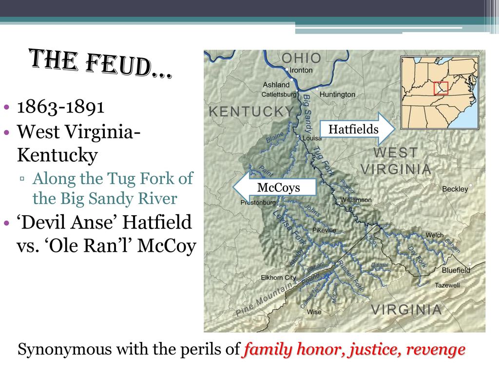
From a slide on a page of history.com
Meanwhile, have a good week. Have a safe one too.
MS
London recorded 12.22" for the month of June, obliterating its previous wettest June on record.
London also recorded its wettest month on record for any month of the year, beating out the previous record of 12.16" set in December 1990.
Jackson 3rd wettest June
Covington/Cincinnati 4th wettest June
Louisville 6th wettest June
Bowling Green 9th wettest June
Lexington and Frankfort fell just outside of their top ten wettest June's on record.
After last evening's rainfall, my June total surpassed the 10" mark, coming in at 10.08". My annual total now stands at 35.61", well ahead of last year's mark at this time.
Oh, and by the way, you will be pleased to know that little sliver of west or south-central Kentucky that was in an "abnormally dry" shading was officially removed during the latest drought monitor report.
Surprisingly, most areas finished near to slightly below normal in the temperature department. This past week of drier and hotter weather really helped out.
I'm seeing signs of an overall national and global shift in temperatures. For the past few years, we have been experiencing much warmer than normal readings, top 5 rankings at least. Hopefully, the cooler pattern we are seeing now will continue and help temper the extreme weather events many locations have experienced over the last several years.
I talked to a farmer from Indiana yesterday, and he said his watermelon crop is a near-total loss. Some fields of central and southern Indiana still have water overlaying the land, prohibiting some from even planting their crops. He informed me that some farmers say this is the worst they've seen it in several decades.
I guess in some ways, too much water is worse than a drought.
Well, the end of the snow season occurred yesterday. You can check out the blog statistics and compare your location with several NWS sites. Some of my favorite tracking locations near the Tug Hill region of western New York saw much less snow this past year compared to previous years. I'm still working on finalizing that data.
Your geography bee of the week has to deal with another "Tug" in its name, the Tug Fork of the Big Sandy river. For years, I always thought the feud of the infamous Hatfield's and McCoy's were separated by a fence. Well, in this case, it's the liquid fence of the Tug Fork, separating Kentucky and West Virginia.
It's been a fascinating, albeit confusing read, these Hatfield's and McCoy's. There were so many of them. And despite the many bloody events, several Hatfield and McCoy members were married to each other, which made it even more difficult to keep track who was supporting what side, if any.
Anyway, it's a piece of Kentucky history. Go to Pikeville sometime or the eastern part of Pike county, where the McCoy's occupied much land. See the other side, where the Hatfield's lived, just across the river in West Virginia.
From a slide on a page of history.com
Meanwhile, have a good week. Have a safe one too.
MS
Subscribe to:
Posts (Atom)
-
Recently, I noticed that our days have now begun to shorten. However, our sunset here in Louisville still remains at 9:10pm edt. Starting th...
-
 In July of this year, I did a segment about the latest sunsets in the eastern time zone. This corresponded nicely with the summer solstice a...
 -
A 1 Temperature C Humidity F Heat Index 2 81 82 86.82 This is an Excel spreadsheet program. Fairly ...
