Seems like 40 days and 40 nights. Follow all the action here with ongoing flooding here and severe weather breaking out west of us.
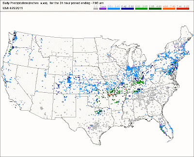
Keep an eye on these rain gages as the precip advances eastward...click on map below.
7:50pm
Watch LIVE streaming video of Little Rock AR; just got a cool lightning bolt in the distance. Tornado warnings just west
http://www.firedominator.com/index.php?pag=live&Stream_ID=626
11:40am
The sun has made an appearance at my location. I've updated my Records...Broken section above the blog. Not a large rise since yesterday thanks to lesser rain amounts. However, if we get that advertised 3-5" from Tue into Wed, river levels will accelerate rapidly higher. Flash flooding will take place as many roads around town will become blocked off.
Even if a road does not have a barricade but has water across it, do not attempt to try and cross it. The road underneath may have washed out or may be too deep to cross. What you can't see CAN HURT! Turn around, don't drown.
10:20am
From our volunteers at CoCoRaHS, here is the nationwide map of reports. The one that piques my interest is the widespread 3-5" amounts that occurred in 24 hours at locations in southern MO and northern AR. I'll be updating my Records...Broken section above blog shortly. I'm taking it down for now.
10:00am
Trying to get caught up on what's been happening. Early this morning, several roads closed because of flooding in Madisonville (Hopkins county KY). Same in Paducah area. Heavy rain with lightning coming our way.
9:50am
Sleep is so overrated. Another batch of storms poised to move into the area soon. So far, only 0.20" at my location in Valley Station since midnight. Storm total for me since Friday April 22 has been 3.97". Check out this dire proclamation in Hazardous Weather Outlook from NWS Louisville:
VERY HEAVY RAIN WILL BE POSSIBLE ACROSS THE REGION TUESDAY AND
WEDNESDAY. THE MOST WIDESPREAD HEAVY RAINFALL IS EXPECTED TO OCCUR
TUESDAY NIGHT INTO WEDNESDAY WITH 24 HOUR RAINFALL AMOUNTS OF 3 TO
LOCALLY 5 INCHES POSSIBLE...ESPECIALLY IN KENTUCKY. IF THIS RAIN
IS MATERIALIZED SEVERE FLOODING PROBLEMS WILL RESULT.
6:30am
Overnight, water rescue in New Albany as Ohio river floodwaters at residence.
MS
Subscribe to:
Post Comments (Atom)
Tornadoes on Easter Sunday
This is a worse case scenario. Tornadoes and flooded, blocked roadways making for great difficulties reaching residences affecting hard hit ...
-
Recently, I noticed that our days have now begun to shorten. However, our sunset here in Louisville still remains at 9:10pm edt. Starting th...
-
In July of this year, I did a segment about the latest sunsets in the eastern time zone. This corresponded nicely with the summer solstice a...
-
A 1 Temperature C Humidity F Heat Index 2 81 82 86.82 This is an Excel spreadsheet program. Fairly ...


Man, HPC is showing 4-6" of rain over a lot of area's is not looking good. For anyone.
ReplyDelete