Thursday, November 17, 2011

November Mid-Month Report and Look Ahead

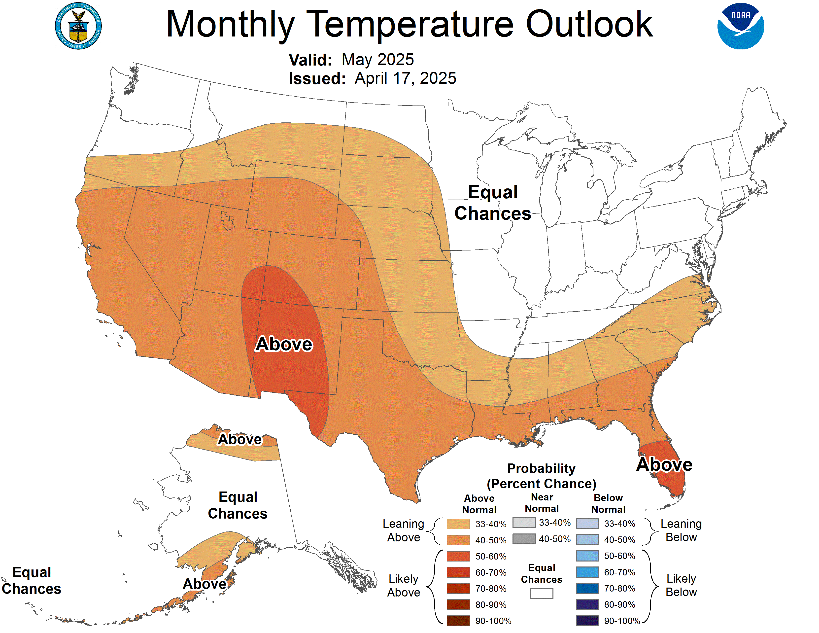
Through the middle of the month, Louisville has enjoyed above average temperatures and below normal rainfall. The Climate Prediction Center is forecasting above normal temps and precip for the rest of the month. In fact, here's a sneak peek at the preliminary outlook for the month of December...

I think many of us are expecting December to make that transition to winter. However, the CPC must see things a little differently. Now, there's still time for the CPC to update this before the end of the month.

I do know one thing in their favor. The models are withholding the colder air from infiltrating our region. Still locked up in Alaska, it's only a matter of time before chunks of that colder air begin dumping into our part of the world. Something to keep an eye on.

Again, something else to keep an eye on is the possibility of more heavy rain moving back into the area. Here is a look at the Sun-Mon time frame...

It appears at least 0.50" is expected for Louisville while heavier amounts could be realized downstate. However, during the holiday week, at least another 2 inches is expected to fall on top of that. If the predicted rain amounts are realized, some minor flooding issues could arise. As always, things change. So, we'll just have to wait and see how the models fine tune the week ahead.

Don't forget to check out my winter weather forecast for 2011/2012. You can find it in the Miks Piks section of my blog.

MS

Just Chillin'

Fairly brisk conditions out there today, adds a bit of a chill that overcomes the warmth of the sun.
Yesterday, Fort Yukon AK recorded a high of -33 and a low of -44. Ouch! In the Antarctic, Vostok recorded a low of -50, actually pretty 'mild' for them.

Last hour, Fairbanks AK is sitting at -40. However, on a 'warmer' note, temperatures in parts of Siberia are being impacted by milder air off the ocean, above zero in several locations. The coldest temperature in Siberia and Eastern Russia I've found during the past hour is -34 at Yakutsk.

I'm always interested in seeing how the weather is in parts of Alaska and Siberia this part of the year, as our weather here could be impacted down the road.

Finally, in the contigious United States, temps are struggling to get out of the teens in parts of North Dakota and Minnesota at this hour.

MS

Great American Smokeout Day

GASO Image
Today is Great American Smokeout Day, encouraging smokers to start now and kick the habit. The University of Kentucky is celebrating its 2nd annual observance of going smoke-free at its campus. Join the millions nationwide who will be participating this day.

More information about the history of the Great American Smokeout Day, click HERE.

And important information from the American Cancer Society available here.

Tuesday, November 15, 2011

EF-1 Tornado Paoli IN

Good morning...last night's storms were quite strong in places, even producing a tornado in Paoli IN, according to preliminary indications from the NWS survey team. Here is their summation so far...

EF1 Tornado in Paoli

A National Weather Service Storm Survey Team has determined that an EF1 tornado struck downtown Paoli on Monday evening.  The team is still evaluating the damage, but preliminary indications are that the tornado had a path length of roughly two miles, and a width of about 100 yards (with straight-line wind damage for about a mile either side of the tornado track).  Wind speeds were probably around 95 mph.

No strong storms anticipated in the region today; however, widespread rains will produce another inch or two across the Louisville area. Then, a decent shot of cold air will infiltrate the area but only for a short time.

MS

Friday, November 4, 2011

MikJournal's OFFICIAL WINTER WEATHER FORECAST 2011/2012

After a few weeks of guiding you through my thoughts about the upcoming winter, it's time to finalize the forecast. The data is in....and here are the results.

I've looked at other years' analogs but still believe that the winter 2000/2001 will match this winter's forecast, despite the increasing possibility that the follow-up La Nina to 2010's could be stronger.

A stronger La Nina just means more extreme events. One thing about the upcoming 2011/2012 winter is the delayed onset of La Nina conditions initially here in our region.

I believe that a good chunk of the month of November will see above average temperatures. I'm not talking balmy, Florida-like conditions but no serious cold outbreaks here. That should lurk just north and northwest of our region. Some indications are showing that the colder air may arrive before Thanksgiving, though.

December will see the transition to a colder pattern, more indicative of winter. Now, there will be some less cold days than other days. However, remember how I mentioned those extreme events? We will begin to see the effects of those. I think it would be quite neat to see some of those direct hits here, but we'll just have to wait and see.

However, don't fret if we miss out on part of the fun, initially. As the month of December progresses, strong low-pressure systems will continue to funnel increasingly colder air into the region.

The cold air invasion should correspond with a strengthening La Nina toward the end of the year and will carry over into the first part of January. I still feel that the main action will occur north of the region; however, dips in the jet stream will allow us a taste of winter's fun.

Then, an Arctic blast will put an end to the 'fun' pattern. The rest of January could prove to be one of the top ten coldest on record for parts of Kentucky and Indiana as wave after wave of Arctic chill grips the area. Along with the bitter cold readings will be shots of clipper-like systems that could deposit an inch or two here or there in our region.

February will start out very cold but modifying with each Pacific coast storm that moves toward the area. Warmer readings will battle the cold lurking to the north. The battle line appears to be drawn across the north and northeast parts of the United States.

Again, our region will be very close to the action. I cannot emphasize enough the 'bust' potential of this forecast. It always seems that Kentucky is right in the middle of the battleground between the winter's fun and winter's done scenario.

--------------------------------------

Here's some things to think about....

If this La Nina proves to be stronger than last year's, expect stronger Low pressure systems. Although these should drag down colder air behind it, keep in mind that ahead of these systems, more warm air will be pumped into the system.

What we need for a mega snowstorm is a strong Low racing northward into Canada, stalling its associated front in the Appalachians with a secondary Low riding up the front thus depositing some healthy snow amounts for some in the region, primarily east. A cutoff Low would be an ideal candidate in a situation like this. The chances for this look more promising in late December and early January though.

If the colder air can become firmly entrenched here in January, I do not foresee any ice storms for the month. However, as February progresses, cold air at the surface may become an issue as 'warmer' storm systems impede the region.

Also, I'll be monitoring the snowpack that will continue to develop across the Canadian regions, as this may impact the amount of cold air we receive.

Regarding the storm systems, from December through February, I'm expecting at least one storm per week. That's at least 12 chances for us getting in on at least some of the 'fun'. This does not include any upper air disturbances that typically rotate around Low pressure systems that can bring generally light precipitation.

-----------------------------------

Finally, let's break it down into information you guys really care about. I have applied what I call a MrHP(Mid-range Highest Probability) analysis. This is not just a national scenario, but global probabilities how this winter should affect parts of the United States.


While this is just an average of the two main storm tracks for this winter, expect fluctuations that could possibly allow for phasing of the storm tracks, which always makes for interesting weather around here. I still believe that east and northeast Kentucky, central and east Indiana, and southern Ohio stand the highest probabilities for much above normal snow chances in our region.

Despite the low probabilities of forecasting actual snow amounts for the winter (Dec-Feb), I'll try and provide snow amounts for selected areas in our region in a future post, based on normal averages for those locations.

Other than that, here's to another winter of possible extremes.

MS

Space Weather - X Class Flares Possible

I don't get much of a chance to talk about space weather. But, we are in an active period when sunspots are the order of the day. And often, from those sunspots, coronal mass ejections of plasma gas protrude and blitz across the heavens at, well, astronomical speeds.

One of the largest sunspots in years is now within our view. At any moment, an eruption of those hot gases could spew out and actually reach earth's atmosphere in as little as 15 minutes.


According to the Space Weather Prediction Center:

2011-11-04 01:39   The First of a String?
NOAA 1339 produced an impulsive R3 (Strong) Radio Blackout at 2027 UTC (4:27 pm EDT) on November 3. If a CME occurred, chances are it is not earth-directed given the far eastern  eruption site on the solar disk. Stay tuned on that bit. The large, bright active region remains potent. Odds are good there's more to come.

X Class flares could result from some of those eruptions.

Here is a nice description of the three primary flares...

Scientists classify solar flares according to their x-ray brightness in the wavelength range 1 to 8 Angstroms. There are 3 categories: X-class flares are big; they are major events that can trigger planet-wide radio blackouts and long-lasting radiation storms. M-class flares are medium-sized; they can cause brief radio blackouts that affect Earth's polar regions. Minor radiation storms sometimes follow an M-class flare. Compared to X- and M-class events, C-class flares are small with few noticeable consequences here on Earth.

Here is a chart of any flare activities and its strength.

latest solar x-ray graph

It appears one has already achieved X Class status, causing a strong radio blackout as described above.

MS

Wednesday, November 2, 2011

Looking At Extreme Temperatures

If you have recently noticed, I've put up an EXTREME list on the right hand side of the blog. I really enjoy the dramatic high/low temperature spreads.

However, in my research, I discovered an unusual temperature anomaly. I still can't figure out if it's legitimate, as I cannot find out any other information other than the NWS office. I guess that will be my next step.

DuBois PA recorded a low of 1 degree yesterday morning.

58
32
26
PA
ALLENTOWN-BETHLEHEM
54
31
23
PA
ALTOONA/BLAIR_CO.
57
32
25
PA
BEAVER_FALLS_ARPT
50
28
22
PA
BRADFORD_REGIONAL
55
30
25
PA
BUTLER_CO._(AWOS)
54
27
27
PA
CLEARFIELD
56
33
23
PA
DOYLESTOWN
51
1
50
PA
DUBOIS/JEFFERSON CO
57
40
17
PA
ERIE/INTL
54
34
20
PA
FRANKLIN(AWOS)
57
33
24
PA
HARRISBURG/CAPITAL
50
31
19
PA
JOHNSTOWN/CAMBRIA
57
35
22
PA
LANCASTER
55
32
23
PA
LATROBE/WESTMORLAND
54
36
18
PA
MEADVILLEWPORT_ARPT
57
34
23
PA
MIDDLETOWN
57
32
25
PA
MUIR_AAF/INDIANTOWN
58
38
20
PA
NORTH PHILADELPHIA
59
41
18
PA
PHILADELPHIA/INTL
57
34
23
PA
PITTSBURGH, COUNTY
57
30
27
PA
PITTSBURGH/GREATER
51
29
22
PA
POCONO_MNTS_MUNIL_ARPT
57
34
23
PA
POTTSTOWN LIMERICK AIR
57
36
21
PA
READING/SPAATZ FLD
58
29
29
PA
SELINSGROVE/PENN_VALLE
54
32
22
PA
STATE_COLLEGE
54
28
26
PA
STEWART_FIELD
57
28
29
PA
WASHINGTON_(AWOS)
55
34
21
PA
WILKES-BARRE-SCRANTON
56
30
26
PA
WILLIAMSPORT/LYCOMING
56
30
26
PA
YORK_ARPT


The following table is from an EXCEL spreadsheet that shows, from left to right, high temp, low temp, spread, state, and reporting location.

Also, I have this graphic to show as well...


Enlarge the map above and look in the lower left graphic, looking in the Northeast U.S. at Pennsylvania. Kinda stands out, doesn't it???

True, several locations had quite a bit of snow over the weekend and this can easily provide the dramatic drop in overnight low temperatures. However, other reporting stations don't really come close to the 1 degree reading at DuBois.

Elevation is not much of an issue, either.

The greatest argument I can provide against using this reading as legitimate is the following observations I copied into my EXCEL spreadsheet from the reporting station.

1
11:56
S 3
A Few Clouds
43
37
30.3
1027
1
10:56
S 5
Overcast
41
37
30.3
1027
1
9:56
SE 3
Overcast
38
34
30.3
1027
1
8:56
Calm
Overcast
34
32
30.3
1027
1
7:56
E 5
Fair
NA
NA
30.3
NA
1
6:56
Calm
Fair
1
NA
30.2
1027
1
5:56
Calm
Fair
1
NA
30.2
1026
1
4:56
Calm
A Few Clouds
NA
NA
30.2
NA
1
3:56
Calm
Mostly Cloudy
NA
NA
30.2
NA
1
2:56
SE 3
Partly Cloudy
NA
NA
30.2
NA
1
1:56
SE 6
Mostly Cloudy
1
NA
40
1
30.2
1026
1
0:56
Calm
Overcast
1
NA
30.2
1026
31
23:56
SE 3
Overcast
39
34
30.2
1025
31
22:56
SE 5
Overcast
39
34
30.2
1025
31
21:56
SE 7
Overcast
39
34
30.2
1025
31
20:56
SE 7
Overcast
39
34
30.2
1024
31
18:56
SE 8
Overcast
41
33
30.2
1024


Notice, specifically, the blue font for the hourly temperature readings. Some type of malfunction must have occurred. As you notice, later in the morning, the reporting station started recording the hourly readings again...at a much higher reading than 1 degree.

Sometimes, these things happen, but can cause confusion for climatologists as they seek to gather correct data for their records.

MS
Tornadoes on Easter Sunday

This is a worse case scenario. Tornadoes and flooded, blocked roadways making for great difficulties reaching residences affecting hard hit ...