Follow me here as I try and sort out the different storm and flood statements. Sporadic updates throughout the day...
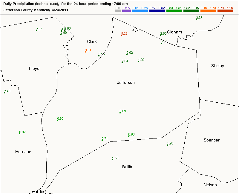
Keep an eye on the rain gages here...
7:00pm
Road Closures in Henderson:
U.S. 60 at MM24 in Union county to MM26 in Henderson county because of major flooding
Golf ball-size hail in Albany KY
In Livingston county at Ledbetter, 5 mobile homes evacuated by fire/rescue at confluence of Tennessee and Ohio rivers
4:45pm
One of the Mesonet sites south of Paducah has recorded nearly 6" since midnight.
----------------------------------------------
Here is a statement from the NWS Louisville about the potential for more flooding...
...LIFE-THREATENING FLOODING SITUATION POSSIBLE THIS EVENING...
ANOTHER INTENSE ROUND OF THUNDERSTORMS WILL MOVE THROUGH SOUTHERN
INDIANA AND CENTRAL KENTUCKY THIS AFTERNOON AND EVENING. RAINFALL
RATES COULD APPROACH 1 TO 2 INCHES PER HOUR WITH THE STRONGEST
STORMS...REDUCING VISIBILITIES AND CAUSING RAPID FLASH FLOODING
AND RIVER RISES. WATER RESCUES AND EVACUATIONS HAVE OCCURRED TO
THE WEST WITH THIS LATEST BATCH OF RAINFALL. THE MOST LIKELY AREAS
TO SEE DANGEROUS FLOODING CONDITIONS WILL BE IN NORTH CENTRAL
KENTUCKY AND SOUTHERN INDIANA WHERE EXCESSIVE RAIN HAS RECENTLY
FALLEN. DUE TO THE ALREADY SATURATED GROUNDS...LESS THAN AN INCH OF
RAIN WILL CAUSE PROBLEMS IN SOME LOCATIONS.
Record flood levels expected in Princeton IN and Smithland KY.
Here is Smithland Lock and Dam's forecast (most recent)
At the record stage of 51.4 ft, large amounts of property damage can be expected; evacuation of many homes and businesses becomes necessary.
More info can be obtained from this link:
http://www.erh.noaa.gov/er/ohrfc/
Batch of storms with a history of severe weather will be moving east and northeast toward our area.
MS
Sunday, April 24, 2011
Hoping April Showers Bring May Flowers...
After another round of moderate to heavy rain this morning, the atmosphere has been overworked...for now.
Look for additional heavy rains returning to the area later today and tonight.
This is from our friends at the CoCoRaHS and some of their 24-hour rainfall amounts in Jefferson county and some adjacent counties. Pretty impressive...Click on the map below.
By the way, we've all heard the saying, "April showers bring May flowers". Well, it's not only a meteorological or a climatological statement, but it's also a proverb.
The expression "April showers bring May flowers" can mean 'some unpleasant occurrences bring about better things.' In other words, endure the downpours of April, then you'll enjoy the flowers of May. Perhaps a lesson in patience.
I hate to ruin the rhyme, but last I heard, May is the most active month for severe weather around here.
I'll be updating rain totals for us here in Louisville and river levels around the region later today.
MS
Look for additional heavy rains returning to the area later today and tonight.
This is from our friends at the CoCoRaHS and some of their 24-hour rainfall amounts in Jefferson county and some adjacent counties. Pretty impressive...Click on the map below.
By the way, we've all heard the saying, "April showers bring May flowers". Well, it's not only a meteorological or a climatological statement, but it's also a proverb.
The expression "April showers bring May flowers" can mean 'some unpleasant occurrences bring about better things.' In other words, endure the downpours of April, then you'll enjoy the flowers of May. Perhaps a lesson in patience.
I hate to ruin the rhyme, but last I heard, May is the most active month for severe weather around here.
I'll be updating rain totals for us here in Louisville and river levels around the region later today.
MS
1997 Flood Crest to be Breached???
One of the worst flooding events for Louisville in my lifetime occurred in 1997. River levels exceeded 38ft at the McAlpine Upper Gauge, some 15ft above flood stage. The Lower Gauge recorded about 70ft, again some 15ft above flood. I recall helping an older man and his wife clean up after the river inundated the first floor of their home. Water was some 4 ft high in the living room. This was along the Dixie Hwy corridor just past Kosmosdale near West Point.
I dug around and located an interesting archive for the 1997 flood in Louisville. The picture below is a view from the Clark Memorial bridge.
You can see additional pics and write-up for this event at the following site below:
http://www.crh.noaa.gov/lmk/?n=flood97
Now, Old Man River is on the move again and threatens to breach that 1997 event. Latest river forecasts may be a bit too conservative. The latest forecast had UG at 33ft and LG at just under 65ft. I've compared the '97 event to this one. Yes, in '97, Louisville set the state all-time 24-hr precip record at 10.48". However, the amount of territory that is being/will be affected by this relentless, prolonged period of heavy rain is what's got me concerned.
The setup for our current flooding event has a forecast for more heavy rains right along the Ohio river and points just north and south. All rivers and other tributaries feed into the Ohio. Historical rainfall records have fallen and others will soon be broken over the next few days. This includes locations like Lexington and Frankfort, where April all-time rainfall records have already occurred. Such a prolonged period of heavy rainfall will not allow the River to recede much before additional heavy rains move in.
I expect flooding along the Ohio to continue through the end of the month and into the first part of Derby week. The Great Steamboat Race could be affected along with regular barge traffic on the river. I'll be posting my pics over the course of the next few days right here. I'll be visiting places like West Point, Greenwood boat ramp, Kosmosdale (near where the Ohio Valley drag strip is located), and others.
Keep checking back.
MS
I dug around and located an interesting archive for the 1997 flood in Louisville. The picture below is a view from the Clark Memorial bridge.
You can see additional pics and write-up for this event at the following site below:
http://www.crh.noaa.gov/lmk/?n=flood97
Now, Old Man River is on the move again and threatens to breach that 1997 event. Latest river forecasts may be a bit too conservative. The latest forecast had UG at 33ft and LG at just under 65ft. I've compared the '97 event to this one. Yes, in '97, Louisville set the state all-time 24-hr precip record at 10.48". However, the amount of territory that is being/will be affected by this relentless, prolonged period of heavy rain is what's got me concerned.
The setup for our current flooding event has a forecast for more heavy rains right along the Ohio river and points just north and south. All rivers and other tributaries feed into the Ohio. Historical rainfall records have fallen and others will soon be broken over the next few days. This includes locations like Lexington and Frankfort, where April all-time rainfall records have already occurred. Such a prolonged period of heavy rainfall will not allow the River to recede much before additional heavy rains move in.
I expect flooding along the Ohio to continue through the end of the month and into the first part of Derby week. The Great Steamboat Race could be affected along with regular barge traffic on the river. I'll be posting my pics over the course of the next few days right here. I'll be visiting places like West Point, Greenwood boat ramp, Kosmosdale (near where the Ohio Valley drag strip is located), and others.
Keep checking back.
MS
Saturday, April 23, 2011
Waterlogged...w/UPDATES
8:08pm
Lexington now has 9.43" for the month of April, AN ALL-TIME RECORD RAINFALL for the month of April.
8:00pm
Louisville has now reached 9.15" for the month, ranking #3 on the all-time rainfall list for April. The record is 11.10". Rainfall at the airport for the storm system is 2.88".
7:40pm
I've scanned some recent river forecasts and found some updates. McAlpine Upper expected to reach 33 ft or 10ft above flood stage. Moderate flooding would occur.
Salt River at Shepherdsville expected to crest just below moderate stage at 34ft, but I think those numbers may be adjusted higher based on expected amounts over the next few days.
7:15pm
I hope they're wrong about this one...From now thru Thursday
5:20pm
Storm reports:
Sparta KY (Owen county) Trees across Hwy 1316; roofs off of outbuildings
Barkley Airport 79 mph wind gust
Downed and uprooted trees in Paducah
Now, t'storm warnings for Breck, Meade, Hardin counties in KY.
2.68" storm total at my location in Valley Station (Louisville)
5:15pm
I'm going to check on storm reports next, but I'm denoting very strong winds indicative of derecho type winds with this bowing segment approaching from the west. Winds at least 70mph possible.
5:05pm
Possible tornadic cell approaching southern parts of Owensboro.
4:50pm
CORRECTION
I knew I was going to do that...Storm total is 2.78" not just today's total. Sorry...but, still think we'll beat that with the next round of storms poised to move in. We needed about another 0.50" or so to beat the daily rainfall record.
4:30pm
Louisville tacked on another 0.51" last hour for storm total of 2.78" and 9.03" for the month.
We only need 0.02" to break the daily record rainfall total set in 1970 for this date. Also, we need 0.06" to move into #3 on the all-time wettest April list.
Lexington still needs 0.06". Heavy rain just north will brush the airport. That should do it.
More on severe weather in a few minutes
4:00pm
Oh yeah, forgot to mention about this thing called a Tornado Watch till 8pm.
Apparent damage in western KY already being reported.
3:25pm
As of 3:00pm, NWS Louisville has now recorded 2.27" for this storm system. And this only partially accounts for a very heavy rain in progress. Rank #5 on all-time rainfall record for April at 8.52"
Flash flood warnings across the board.
Over 1.7" since midnight.
Also, Lexington has recorded 1.4" today. Only 0.06" more and a new all-time rainfall record will be set for the month of April.
Do I need to say more?
As of 10am this morning, total rainfall from this storm system has been 2.02"
Month to date: 8.27"
Rank: 6th wettest April on record
More heavy rain to come, along with a chance for severe storms.
MS
Lexington now has 9.43" for the month of April, AN ALL-TIME RECORD RAINFALL for the month of April.
8:00pm
Louisville has now reached 9.15" for the month, ranking #3 on the all-time rainfall list for April. The record is 11.10". Rainfall at the airport for the storm system is 2.88".
7:40pm
I've scanned some recent river forecasts and found some updates. McAlpine Upper expected to reach 33 ft or 10ft above flood stage. Moderate flooding would occur.
Salt River at Shepherdsville expected to crest just below moderate stage at 34ft, but I think those numbers may be adjusted higher based on expected amounts over the next few days.
7:15pm
I hope they're wrong about this one...From now thru Thursday
5:20pm
Storm reports:
Sparta KY (Owen county) Trees across Hwy 1316; roofs off of outbuildings
Barkley Airport 79 mph wind gust
Downed and uprooted trees in Paducah
Now, t'storm warnings for Breck, Meade, Hardin counties in KY.
2.68" storm total at my location in Valley Station (Louisville)
5:15pm
I'm going to check on storm reports next, but I'm denoting very strong winds indicative of derecho type winds with this bowing segment approaching from the west. Winds at least 70mph possible.
5:05pm
Possible tornadic cell approaching southern parts of Owensboro.
4:50pm
CORRECTION
I knew I was going to do that...Storm total is 2.78" not just today's total. Sorry...but, still think we'll beat that with the next round of storms poised to move in. We needed about another 0.50" or so to beat the daily rainfall record.
4:30pm
Louisville tacked on another 0.51" last hour for storm total of 2.78" and 9.03" for the month.
We only need 0.02" to break the daily record rainfall total set in 1970 for this date. Also, we need 0.06" to move into #3 on the all-time wettest April list.
Lexington still needs 0.06". Heavy rain just north will brush the airport. That should do it.
More on severe weather in a few minutes
4:00pm
Oh yeah, forgot to mention about this thing called a Tornado Watch till 8pm.
Apparent damage in western KY already being reported.
3:25pm
As of 3:00pm, NWS Louisville has now recorded 2.27" for this storm system. And this only partially accounts for a very heavy rain in progress. Rank #5 on all-time rainfall record for April at 8.52"
Flash flood warnings across the board.
Over 1.7" since midnight.
Also, Lexington has recorded 1.4" today. Only 0.06" more and a new all-time rainfall record will be set for the month of April.
Do I need to say more?
As of 10am this morning, total rainfall from this storm system has been 2.02"
Month to date: 8.27"
Rank: 6th wettest April on record
More heavy rain to come, along with a chance for severe storms.
MS
Friday, April 22, 2011
Storm Updates Apr 22
6:50pm
TORNADO WATCH for the area till 2:00am edt.
Still, a number of funnel cloud sightings now across Anderson county and Lawrenceburg. No tornado touchdowns yet.
6:05pm
Tornado warning for parts of Spencer county where strongest rotation will be. Otherwise, at my location during the last hour, just heavy rain and some lightning. No hail or high winds. 0.40" recorded here in Valley Station during the past hour. I'll be updating Louisville's monthly total above this post. Remember, the all-time rainfall record for April is 11.10"
5:05pm
Rainfall estimated 0.5 - 1.2" in the last hour across many sections to our west.
4:35pm
Dewpoints in mid 60's in Louisville as storms approach. LI's now approaching -3. Heavy rain and some hail along with gusty winds expected. Noticing darker clouds to my northwest.
4:25pm
No severe weather reported in KYor IN yet. Some small hail is quite likely falling with some of the stronger cells along with 30-40mph winds.
Dewpoints are becoming sticky at my location
3:35pm
Lightning counts have increase nearly 30% during the past couple of hours.
http://www.strikestarus.com/index.aspx?id=30
I am also noticing an increasing wind threat as storms push thru Jasper. Probably 30-40mph.
That line may approach Louisville area by 5:00pm.
3:15pm
Strong/severe storm moving thru Vincennes IN. Storm report out shortly...
Additional storms are firing in the increasingly unstable airmass.
50-60kt bulk shear to the west. LI's turning increasingly negative locally. Hail still looks to be the main threat but wind threat should increase soon.
2:30pm
Severe Thunderstorm Watch box issued for parts of north central KY and all of southern IN. Large hail has been a primary culprit but damaging wind is also a possibility.
Some selected probabilities from the SPC include:
Severe wind MOD
Severe hail MOD
Hail>2" LOW
Strong Tornadoes LOW
1:25pm
No thunder in Louisville, just light rain. E'town receiving heavy thunderstorm, with possible dime-size hail.
Looking at current lightning strike activity, lightning count has diminished somewhat over the past hour over MO and IL.
12:25pm
Band of thunderstorms approaching Louisville. Nothing severe yet, but the line is strengthening.
Check this site for latest lightning strikes.
http://www.strikestarus.com/
TORNADO WATCH for the area till 2:00am edt.
Still, a number of funnel cloud sightings now across Anderson county and Lawrenceburg. No tornado touchdowns yet.
6:05pm
Tornado warning for parts of Spencer county where strongest rotation will be. Otherwise, at my location during the last hour, just heavy rain and some lightning. No hail or high winds. 0.40" recorded here in Valley Station during the past hour. I'll be updating Louisville's monthly total above this post. Remember, the all-time rainfall record for April is 11.10"
5:05pm
Rainfall estimated 0.5 - 1.2" in the last hour across many sections to our west.
4:35pm
Dewpoints in mid 60's in Louisville as storms approach. LI's now approaching -3. Heavy rain and some hail along with gusty winds expected. Noticing darker clouds to my northwest.
4:25pm
No severe weather reported in KYor IN yet. Some small hail is quite likely falling with some of the stronger cells along with 30-40mph winds.
Dewpoints are becoming sticky at my location
3:35pm
Lightning counts have increase nearly 30% during the past couple of hours.
http://www.strikestarus.com/index.aspx?id=30
I am also noticing an increasing wind threat as storms push thru Jasper. Probably 30-40mph.
That line may approach Louisville area by 5:00pm.
3:15pm
Strong/severe storm moving thru Vincennes IN. Storm report out shortly...
Additional storms are firing in the increasingly unstable airmass.
50-60kt bulk shear to the west. LI's turning increasingly negative locally. Hail still looks to be the main threat but wind threat should increase soon.
2:30pm
Severe Thunderstorm Watch box issued for parts of north central KY and all of southern IN. Large hail has been a primary culprit but damaging wind is also a possibility.
Some selected probabilities from the SPC include:
Severe wind MOD
Severe hail MOD
Hail>2" LOW
Strong Tornadoes LOW
1:25pm
No thunder in Louisville, just light rain. E'town receiving heavy thunderstorm, with possible dime-size hail.
Looking at current lightning strike activity, lightning count has diminished somewhat over the past hour over MO and IL.
12:25pm
Band of thunderstorms approaching Louisville. Nothing severe yet, but the line is strengthening.
Check this site for latest lightning strikes.
http://www.strikestarus.com/
Severe Weather/Flooding Kicks Off Easter Weekend
A very active holiday weekend indeed is unfolding right now primarily to our west and northwest. Look for our weather to begin deteriorating this afternoon in the Louisville area.
At the moment, the severe parameters I've been looking at are pretty tame. However, there were 3 pockets of concern. The closest one of those pockets to us will be harassing St Louis vicinity. A great deal of shear is present all along this warm frontal boundary. Although LI's are not very impressive along with CAPE vals being a non-factor, look for these parameters to become more ominous later today, particularly as they approach the Louisville area.
The other pocket of concern will probably occur later tonight as precip has not even broke out yet in eastern OK and western MO. Shear values are quite high and LI's already in the -4 range along with CAPE vals around 2000. Not bad for this time of day. Of course, dewpoint readings will be on the rise and will help 'juice up' the atmosphere.
If anything, look for quite a bit of heavy rain, especially along and north of the Ohio river. My current thinking is the heaviest rain will fall across water-logged southern Indiana for today. For tonight and tomorrow, that will shift a little bit south in our area. Current thinking is still 2-4", depending on thunderstorms and 'training'.
Graphics and additional thoughts later.
MS
At the moment, the severe parameters I've been looking at are pretty tame. However, there were 3 pockets of concern. The closest one of those pockets to us will be harassing St Louis vicinity. A great deal of shear is present all along this warm frontal boundary. Although LI's are not very impressive along with CAPE vals being a non-factor, look for these parameters to become more ominous later today, particularly as they approach the Louisville area.
The other pocket of concern will probably occur later tonight as precip has not even broke out yet in eastern OK and western MO. Shear values are quite high and LI's already in the -4 range along with CAPE vals around 2000. Not bad for this time of day. Of course, dewpoint readings will be on the rise and will help 'juice up' the atmosphere.
If anything, look for quite a bit of heavy rain, especially along and north of the Ohio river. My current thinking is the heaviest rain will fall across water-logged southern Indiana for today. For tonight and tomorrow, that will shift a little bit south in our area. Current thinking is still 2-4", depending on thunderstorms and 'training'.
Graphics and additional thoughts later.
MS
Thursday, April 21, 2011
Breaking It Down
***4:00pm edt UPDATE***
Flash Flood Watch in effect for 2-4" rain
---------------
Quite a bit to get to, so let's get started.
In a previous post, I mentioned Louisville's 124-year long record for Friday April 22 rainfall of 3.08". Here is a map from the HPC that shows the possible rain amounts from now thru Saturday morning.
STRONGLY SHEARED ENVIRONMENT FOR SUPERCELLS...INCLUDING THE
POSSIBILITY FOR A FEW TORNADOES...VERY LARGE HAIL AND DAMAGING
WINDS. THIS ACTIVITY SHOULD SPREAD DOWNSTREAM INTO THE LOWER OH
VALLEY INTO A RECOVERING AIRMASS IN THE WAKE OF NWD SHIFTING WARM
FRONT.
I'm not yet posting my thoughts about the upcoming storm system, as there are too many uncertainties. Yes, I do think there will be severe weather in our region. However, some areas may not get the needed instability for a widespread event like what we just witnessed during the April 19-20 event. We'll see how future forecast models are handling the data for a better indication of our severe weather chances locally.
By the way, while many now confirmed tornadoes have been recorded for many areas near Louisville, we really dodged a bullet, as winds peaked at 52mph at the Airport. No significant damage in my area as well. And yay, the power stayed on.
More updates later.
MS
Flash Flood Watch in effect for 2-4" rain
---------------
Quite a bit to get to, so let's get started.
In a previous post, I mentioned Louisville's 124-year long record for Friday April 22 rainfall of 3.08". Here is a map from the HPC that shows the possible rain amounts from now thru Saturday morning.
As of now, we are included in the 3"+ category. Will it all occur on Friday, though? Tough to say. Regardless, even if the daily record for rainfall does not happen, these amounts will only prolong regional flooding issues, especially along the Ohio river and other smaller rivers in southern Indiana.
By the way, here is a list of the TOP TEN WETTEST APRILS for Louisville.
1 1970 - 11.10"
2 1966 - 9.56"
3 1872 - 9.08"
4 1912 - 8.60"
5 1972 - 8.48"
6 1893 - 7.69"
7 1892 - 7.50"
8 1979 - 7.32"
9 1887 - 7.31"
10 1940 - 7.21"
As of this post, we are at 6.24". With heavy rain expected this weekend and more on tap for next week, we could very well challenge the all-time record rainfall for April. We should at least post in the top 3 wettest Aprils.
I'll be posting the current April rainfall along with other records in jeopardy for the rest of the month just below my Title Page.
In addition, Lexington's all-time record rainfall for April is 9.30". Currently they are around 7.50". Looks like a done deal for them, as they may eclipse the record this weekend.
Next, the severe threat is beginning to loom large once again for our region. The SPC has shifted its hatch marks closer to Louisville now. Take a look.
Many of these areas will quite likely be upgraded to a MODERATE risk, or at least a 45% probability for significant severe weather.
Here is what they are saying:
MODEST INSTABILITY WILL BE IN PLACE BY
MID AFTERNOON FOR ROBUST THUNDERSTORM DEVELOPMENT ACROSS MO WITHIN ASTRONGLY SHEARED ENVIRONMENT FOR SUPERCELLS...INCLUDING THE
POSSIBILITY FOR A FEW TORNADOES...VERY LARGE HAIL AND DAMAGING
WINDS. THIS ACTIVITY SHOULD SPREAD DOWNSTREAM INTO THE LOWER OH
VALLEY INTO A RECOVERING AIRMASS IN THE WAKE OF NWD SHIFTING WARM
FRONT.
I'm not yet posting my thoughts about the upcoming storm system, as there are too many uncertainties. Yes, I do think there will be severe weather in our region. However, some areas may not get the needed instability for a widespread event like what we just witnessed during the April 19-20 event. We'll see how future forecast models are handling the data for a better indication of our severe weather chances locally.
By the way, while many now confirmed tornadoes have been recorded for many areas near Louisville, we really dodged a bullet, as winds peaked at 52mph at the Airport. No significant damage in my area as well. And yay, the power stayed on.
More updates later.
MS
Subscribe to:
Posts (Atom)
Tornadoes on Easter Sunday
This is a worse case scenario. Tornadoes and flooded, blocked roadways making for great difficulties reaching residences affecting hard hit ...
-
Recently, I noticed that our days have now begun to shorten. However, our sunset here in Louisville still remains at 9:10pm edt. Starting th...
-
Although snow totals were a bit inflated for several locations by the different models, I still believe the amounts I had forecast were not ...
-
In July of this year, I did a segment about the latest sunsets in the eastern time zone. This corresponded nicely with the summer solstice a...