| Total Reports = 4 |
| Tornadoes = 1 |
| Hail Reports = 1 |
| Wind Reports = 2 It is still unchanged since earlier in the month. Yes, we did have quite a few severe thunderstorm warnings recently, but no severe weather or damage was received. That might change soon. Another threat for severe weather could happen as early as tomorrow morning. This one looks more promising. I say that because the warm front may trigger a round of severe weather with large hail being the main player initially. Then, a squall line is expected to develop and race ahead of the cold front. The Storm Prediction Center admits a great deal of uncertainty exists with how these moving parts will interact. But, the elements for severe storm development will be there. The one thing I noticed that may favor severe storms is that dewpoint readings will be higher this time around than last time. We had dewpoints in the low 50's, that with surface temperatures exceeding 80 degrees at Louisville on Friday. However, dewpoint temperatures are expected to be in the upper 50's at the very least for this go around, mainly along the cold front. But, the warm front itself may generate hail exceeding severe criteria (which is at least 1.00" in diameter or otherwise). I would describe it in terms of coins, but, the actual diameter of a quarter is less than 1.00", which should not be used in my opinion. I therefore agree with the SPC's assessment with this quote: "We encourage measurement, not estimation, of hail size." So, for right now, let's see how these moving parts unfold. But, be aware, large hail along the warm front and damaging wind along a squall line later are the primary modes of severe weather potential. Keep weather radios on standby, and have quick access to your favorite media source for the most current updates. Also, the statewide tornado drill will now be on Friday, March 3 at 10:07 a.m. est. With so much winter warmth, no wonder severe weather is off and running. I did some projections and discovered that Lexington should record their 2nd warmest winter season ever. Bowling Green should also record its 2nd warmest winter ever. Louisville should record its 7th warmest winter ever. By the middle of next month, I will be switching to the Spring page, yes, getting away from the winter (or should I say the lack of winter) page. Severe storm stats will likely dominate the page. Every now and then, I would like to post an occasional standout storm from the history books. I will post more information on here if any significant updates come my way. MS |
Monday, February 27, 2017
MikJournal Monday 02/27/2017...Winter Warmth and Severe Weather
This is Kentucky's most current preliminary reports of severe weather for 2017....

Sunday, February 26, 2017
In Memory of Bill Paxton...
One of my favorite movies from several years ago...and, well, still is.
Thanks for the memories.
MS
Friday, February 24, 2017
Busy Weather Day Today
It looks like a severe weather event will impact our region later today. Most, if not all, of the ingredients will be present for a damaging wind event this afternoon and evening. The only question I have is "how strong will the 'cap' be?" A secondary one could be "how long after sunset will it take for the intensity of an expected squall line to wane?"
Analogs and models, the SPC, everyone seems to be on board. This was highlighted earlier this week. There has been little change in the overall setup of this thing.
I have looked at past analogs and have found a damaging wind threat exists all along the line. So, once (IF) the cap breaks before sundown, discrete cells will go up quickly, congealing into a linear/squall shortly afterwards.
My confidence meter for this event is fairly high. I looked at the morning clouds, the smell of Spring in the air, the winds, falling pressure (right now at 1005mb/29.70"Hg).
Winds are going to be very gusty pre-frontal passage, likely exceeding 40 mph at times.
A classic setup for severe weather today. It's still difficult for me to determine who will see the brunt of the bad weather. However, a 100-mile wide area could be impacted by the squall line that might produce the most damage.
Again, we'll have to wait and see when the cap begins to erode. This could affect the evolution and strength of the impending event. But, the threat is unusually high for our region to be impacted.
Weather radios on standby. Your favorite media source, whether online or television, ready to go.
MS
Analogs and models, the SPC, everyone seems to be on board. This was highlighted earlier this week. There has been little change in the overall setup of this thing.
I have looked at past analogs and have found a damaging wind threat exists all along the line. So, once (IF) the cap breaks before sundown, discrete cells will go up quickly, congealing into a linear/squall shortly afterwards.
My confidence meter for this event is fairly high. I looked at the morning clouds, the smell of Spring in the air, the winds, falling pressure (right now at 1005mb/29.70"Hg).
Winds are going to be very gusty pre-frontal passage, likely exceeding 40 mph at times.
A classic setup for severe weather today. It's still difficult for me to determine who will see the brunt of the bad weather. However, a 100-mile wide area could be impacted by the squall line that might produce the most damage.
Again, we'll have to wait and see when the cap begins to erode. This could affect the evolution and strength of the impending event. But, the threat is unusually high for our region to be impacted.
Weather radios on standby. Your favorite media source, whether online or television, ready to go.
MS
Monday, February 20, 2017
MikJournal Monday 02/20/2017...More Broken Records
It's beginning to sound like a broken record, but daily record high temperatures, top ten warmest February's on record, and top ten warmest meteorological winters (Dec-Feb) on record are imminent.
I am not just referring to our region, but some climatic centers will likely record well-above normal winter temperatures. In fact, I wonder if this could be the warmest winter on record for the nation. Well, I don't know that, but I may make that a future project.
How about all of that rain in California? It sure looks like the big time drought is over. And all of that snow in the higher elevations? I saw reports of a location that has now recorded over 460" snow. In fact, some within that same mountainous area are expecting between 2 and 5 feet of additional accumulation this week.
I'll try to post numbers for our unusually warm February, that following a very mild January.
Could this lead to some severe weather later this week? There are signals. But, all parameters still need to align for such an event in our region.
Now, I have to cut this post short. My little daughter probably has the flu, and I am her chauffeur to the doctor's office.
MS
I am not just referring to our region, but some climatic centers will likely record well-above normal winter temperatures. In fact, I wonder if this could be the warmest winter on record for the nation. Well, I don't know that, but I may make that a future project.
How about all of that rain in California? It sure looks like the big time drought is over. And all of that snow in the higher elevations? I saw reports of a location that has now recorded over 460" snow. In fact, some within that same mountainous area are expecting between 2 and 5 feet of additional accumulation this week.
I'll try to post numbers for our unusually warm February, that following a very mild January.
Could this lead to some severe weather later this week? There are signals. But, all parameters still need to align for such an event in our region.
Now, I have to cut this post short. My little daughter probably has the flu, and I am her chauffeur to the doctor's office.
MS
Sunday, February 19, 2017
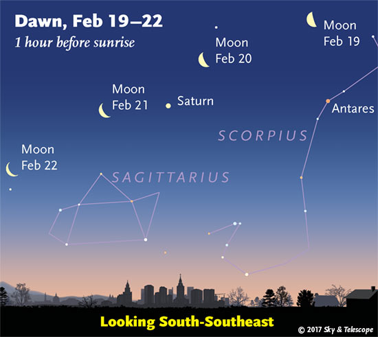
Early Riser...Look to the South-Southeast Sky
Monday, February 13, 2017
MikJournal Monday 02/13/2017...Severe Stats
January proved to be a violent month of severe weather across parts of the south. Already, there had been 20 tornado fatalities for the month of January. That statistic is more than the total number for all of 2016.

Kentucky
|
| Total Reports = 4 |
| Tornadoes = 1 |
| Hail Reports = 1 |
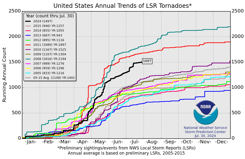
| Wind Reports = 2 The above map for Kentucky represents preliminary reports of severe weather received so far through February 11. As you can see, a tornado report was received on February 7 in western Kentucky near Cadiz in Trigg County. According to the Paducah NWS, it was confirmed that an EF-0 tornado caused some damage mainly to trees near the Cadiz area. Some barns were also impacted. In addition, quarter-size to golf-ball size hail was reported in and around the same area. I am providing a link from the NWS. Click here. Nationally, the tornado count is way above average. It's still early, but I have been anticipating an active severe weather calendar year. In fact, if you look at the chart below, you will notice that we are already on track to record the most tornadoes since 2008, possibly eclipsing 2011's reports. So far this month, I have not read of any fatalities associated with the 20 or so tornado reports, but there have been many injuries, last count was about 36. Spring seems to be starting earlier this year. Although I am not counting out Winter just yet, the unseasonable warmth will continue to battle with Winter's last gasps leading to severe weather events. This is now the 2nd time this year I have mentioned the threat for an active severe weather year. Where most of the severe weather will happen nobody knows. But, even California is getting more severe weather reports than usual. Western Kentucky has already recorded a confirmed tornado. Be prepared. A weather radio is recommended. Keep an eye to the sky. Take an online class or attend one of the Spotter classes to help the NWS know what's happening based on your report from your location. Of course, safety is paramount. Never place yourself directly in harm's way. While it's nice to get the 'picture' or 'video', immediate relay of information is essential for the NWS to issue statements for adjoining locations in the path of any dangerous storm. I have been doing this for several years. I have great respect for lightning and high winds. Perhaps it's my age, but my daring adventures of long ago have transitioned to getting reports out as soon as it is safe to do so and communications equipment have not been damaged or disrupted. Have a safe year, everyone. MS |
Sunday, February 12, 2017
Mount Washington Observatory in New Hampshire
This is one of several favorite locations I use when analyzing weather data. It's claim is 'the world's worst weather'.
I just happened to notice the other day that Mount Washington, at an elevation of 6288 ft, recorded the nation's low temperature at -22 degrees (does not include Alaska).
In addition, winds averaged nearly 70 mph for the day with a peak gust of 120 mph.
Since the average temperature for that day came to -11 (high of -1 and low of -22), and winds averaged nearly 70 mph, the wind chill was a take-my-breath-away -50 degrees.
With the next impending system, snowfall is expected to be in the 2-feet range and, depending on the exact track of the storm system, winds could gust to between 100 and 150 mph.
Check out the site.
https://www.mountwashington.org/
MS
I just happened to notice the other day that Mount Washington, at an elevation of 6288 ft, recorded the nation's low temperature at -22 degrees (does not include Alaska).
In addition, winds averaged nearly 70 mph for the day with a peak gust of 120 mph.
Since the average temperature for that day came to -11 (high of -1 and low of -22), and winds averaged nearly 70 mph, the wind chill was a take-my-breath-away -50 degrees.
With the next impending system, snowfall is expected to be in the 2-feet range and, depending on the exact track of the storm system, winds could gust to between 100 and 150 mph.
Check out the site.
https://www.mountwashington.org/
MS
Subscribe to:
Posts (Atom)
Tornadoes on Easter Sunday
This is a worse case scenario. Tornadoes and flooded, blocked roadways making for great difficulties reaching residences affecting hard hit ...
-
Recently, I noticed that our days have now begun to shorten. However, our sunset here in Louisville still remains at 9:10pm edt. Starting th...
-
In July of this year, I did a segment about the latest sunsets in the eastern time zone. This corresponded nicely with the summer solstice a...
-
Although snow totals were a bit inflated for several locations by the different models, I still believe the amounts I had forecast were not ...