Good morning. Yes, I'm still here. It's been a while since my last post. Gardening, chores, vacation, and other outdoor activities have kept me pretty busy. I finally updated some statistics on the side of my blog (been almost a month). Feel free to check those out.
One of the things you have probably noticed this summer is the heat. It's been rather hot around here. The urban island effect, which I live nearby, has seen temperatures as hot as 98 degrees, without the heat index. Include that calculation, some here in Jefferson county have experienced the 'feel like' temperature of near 110 degrees.
Most areas of Kentucky have seen above normal precipitation for the year. Ironically, Bowling Green is just below normal. Before yesterday's beneficial rainfall, they had only recorded 0.04" for the month of July. Some areas of western Kentucky are not benefiting from much rainfall for the month either. Throw in the heat, and all of what moisture was in the soil is now being quickly evaporated, leading to the top 2" of the soil becoming quite hard. No, it's not a drought. However, if conditions persist for the rest of the month, which it does not appear will be the case, abnormally dry patches may show up on the upcoming drought monitors.
Severe weather has been pretty active this year in Kentucky. Thankfully, I haven't seen much here. The most damage I've seen this year in my neighborhood was from gradient winds in the early Spring that produced a series of 50 mph wind gusts lasting nearly 20 minutes (and that was at night). Yet, in several Kentucky communities, tornado sirens have been a common occurrence, and several tornadoes have been confirmed, even here in Jefferson county.
With a possible weak el nino developing, it will be interesting to see if this becomes a dominant atmospheric driver leading into winter. Since it is expected to be a weak el nino, I'm not expecting a significant correlation to our upcoming winter season but may impact the hurricane season.
The last el nino we had was in 2015. That one was pretty strong and was a dominant driver extending well into winter. However, its impacts were variable here in Kentucky. Snow was above normal for most locations. Here in Louisville and Lexington, we had nearly 15" (this past winter, though not an el nino, we saw between 19-21"). But, temperatures were the big thing. Record warmth in December and impressive warmth in the following February of 2016 produced a well above average winter.
I believe the Sea Surface Temperatures in the far north, between Siberia and Alaska, will continue to impact the warmer than normal climate there, even without the influence of an el nino. In winter, waves of cold shots will penetrate the U.S. mainland. However, the cold shots are likely to be brief. If we do get a prolonged stretch of cold weather, it will likely be offset by a warmer pattern that will cancel things out anyway.
Remember the winter of 2017/18? December and January saw below normal temperatures. Louisville even recorded 6 consecutive days of single-digit low temperatures in one January stretch. Only to have February's impressive warmth skew the entire winter to an above normal temperature season. Crazy stuff!
Enjoy the rest of your week. I'll check in from time to time.
MS
Monday, July 16, 2018

Wednesday, June 20, 2018
Today's Featured Analog...June 20, 2015
In the grips of a typical June heat wave, a pattern change looks to bring a period of wet weather to our gardens. In fact, it's possible that the rest of the month will feature above normal precipitation.
One of the top 15 analogs features one from June 20, 2015. Looking back at past storm reports and rainfall data, tropical moisture from the remnants of Bill resided over our region for a few days producing copious amounts of rainfall. Even severe weather was reported.
Over 4" rainfall accumulated over 7 consecutive days. Prior to this, the first half of June was typically dry, with less than 0.50" at Louisville. However, the second half of the month dealt a prolonged period of heavy rainfall and high winds at times. In addition to the 7-day stretch, there was also a 3-day period later in the month with over 2" reported at Louisville.
Therefore, over 6" fell during the second half of the month, falling just outside of Louisville's top ten wettest June's.
Remember, analogs only show a similar weather pattern that resembles the air mass and expected conditions presently. It does not mean we will see that exact type of weather. However, heavy rainfall over the next two weeks is very possible. Louisville has already recorded nearly 3" for the month. To achieve a top ten wettest June status, the monthly minimum amount needed is 7.01".
Although the WPC keeps the heaviest rainfall just north of the area, I would not be surprised to see some higher localized amounts across parts of our region due to the possible 'training' and slow movement of any storms.
We will see. Meanwhile, enjoy the respite from the heat especially tomorrow and Friday. Turn around and don't drown.
MS
One of the top 15 analogs features one from June 20, 2015. Looking back at past storm reports and rainfall data, tropical moisture from the remnants of Bill resided over our region for a few days producing copious amounts of rainfall. Even severe weather was reported.
Over 4" rainfall accumulated over 7 consecutive days. Prior to this, the first half of June was typically dry, with less than 0.50" at Louisville. However, the second half of the month dealt a prolonged period of heavy rainfall and high winds at times. In addition to the 7-day stretch, there was also a 3-day period later in the month with over 2" reported at Louisville.
Therefore, over 6" fell during the second half of the month, falling just outside of Louisville's top ten wettest June's.
Remember, analogs only show a similar weather pattern that resembles the air mass and expected conditions presently. It does not mean we will see that exact type of weather. However, heavy rainfall over the next two weeks is very possible. Louisville has already recorded nearly 3" for the month. To achieve a top ten wettest June status, the monthly minimum amount needed is 7.01".
Although the WPC keeps the heaviest rainfall just north of the area, I would not be surprised to see some higher localized amounts across parts of our region due to the possible 'training' and slow movement of any storms.
We will see. Meanwhile, enjoy the respite from the heat especially tomorrow and Friday. Turn around and don't drown.
MS
Monday, May 28, 2018
MikJournal Monday 05/28/2018...Alberto
Good Monday to you. For many, it is a day off thanks to the Memorial Day holiday. Unfortunately for some residents in the U.S., this Memorial Day weekend will be remembered for years to come.
Extensive flash flooding occurred near Baltimore, Maryland in an area that saw the same kind of flash flooding in 2016. Nearly 10" rain fell in about a 4-hour period. You can blame it on topography, poor planning for helping divert flood waters, whatever, you're still going to have problems when that much rain falls in a short period of time. I don't care how good your infrastructure for handling heavy rainfall, someone is going to be negatively impacted by such an event.
Alberto, a hybrid tropical system, is poised to bring rain and wind to the panhandle of Florida and will eventually affect our weather here in Kentucky. A consistent theme shows the models bringing whatever is left of Alberto into Kentucky. That means heavy rainfall and some windy conditions, but of some concern too is the threat for brief tornadoes. Anywhere from 1 - 3.5" can be expected, with the heaviest rainfall totals west of I-75.
In other news, Hawaii's Kilauea volcano is being monitored for ashfall by means of radar data. Using this data in combination with prevailing winds can track where locations may be affected by the irritants associated with volcanic ash, such as burning of the eyes and respiratory issues.
It appears Mount Baker and Mount Rainier at Paradise in Washington state are having a friendly competition for the season's most snowfall. Although the season ends June 30, the window for accumulating snow is narrowing. Presently, Mount Baker has received 728" while Paradise has received just over 700" since the snow season began last July 1.
Also, it looks like Louisville and Lexington will easily break their all-time records for warmest May ever. Paducah, Frankfort, Jackson, and London looks like they will too. Bowling Green is on track to record its warmest May ever but may be impacted by the rainfall coming in this week. Still, I think they can do it.
One final thing. This time of year, the official kick-off to summer is in full swing. But, tomorrow May 29 in the year 1982, a little place in Montana called Shonkin or nearby this location, recorded 48" snowfall in a 24-hour period. Simply amazing! According to NCDC's Storm Publication, from May 28-30, as much as 5 feet of snow fell across the north slopes of the Bears Paw, Little Belt, and Snowy Mountains and the east slopes of the Sweetgrass hills. Drifts of 10-15 feet deep closed roads, downed power lines, and buried sheep and cattle.
Whatever happened during that storm system may have contributed to severe weather here with large hail in central and north-central Kentucky and ushered in a period of cool weather for the month of June. In fact, it was the 4th coolest June on record in Louisville. Although July would mark a brief return of summer, August would end up being the 9th coolest August on record.
Have a good week everyone.
MS
Extensive flash flooding occurred near Baltimore, Maryland in an area that saw the same kind of flash flooding in 2016. Nearly 10" rain fell in about a 4-hour period. You can blame it on topography, poor planning for helping divert flood waters, whatever, you're still going to have problems when that much rain falls in a short period of time. I don't care how good your infrastructure for handling heavy rainfall, someone is going to be negatively impacted by such an event.
Alberto, a hybrid tropical system, is poised to bring rain and wind to the panhandle of Florida and will eventually affect our weather here in Kentucky. A consistent theme shows the models bringing whatever is left of Alberto into Kentucky. That means heavy rainfall and some windy conditions, but of some concern too is the threat for brief tornadoes. Anywhere from 1 - 3.5" can be expected, with the heaviest rainfall totals west of I-75.
In other news, Hawaii's Kilauea volcano is being monitored for ashfall by means of radar data. Using this data in combination with prevailing winds can track where locations may be affected by the irritants associated with volcanic ash, such as burning of the eyes and respiratory issues.
It appears Mount Baker and Mount Rainier at Paradise in Washington state are having a friendly competition for the season's most snowfall. Although the season ends June 30, the window for accumulating snow is narrowing. Presently, Mount Baker has received 728" while Paradise has received just over 700" since the snow season began last July 1.
Also, it looks like Louisville and Lexington will easily break their all-time records for warmest May ever. Paducah, Frankfort, Jackson, and London looks like they will too. Bowling Green is on track to record its warmest May ever but may be impacted by the rainfall coming in this week. Still, I think they can do it.
One final thing. This time of year, the official kick-off to summer is in full swing. But, tomorrow May 29 in the year 1982, a little place in Montana called Shonkin or nearby this location, recorded 48" snowfall in a 24-hour period. Simply amazing! According to NCDC's Storm Publication, from May 28-30, as much as 5 feet of snow fell across the north slopes of the Bears Paw, Little Belt, and Snowy Mountains and the east slopes of the Sweetgrass hills. Drifts of 10-15 feet deep closed roads, downed power lines, and buried sheep and cattle.
Whatever happened during that storm system may have contributed to severe weather here with large hail in central and north-central Kentucky and ushered in a period of cool weather for the month of June. In fact, it was the 4th coolest June on record in Louisville. Although July would mark a brief return of summer, August would end up being the 9th coolest August on record.
Have a good week everyone.
MS
Sunday, May 27, 2018
Rainfall For My Garden...Finally
Except for a decent shower on the 16th of this month, which amounted to 0.39", my garden has not had much to be happy about since planting on the 15th. Very warm, if not hot, and dry conditions has affected the soil down about 2". That is not good for young pepper plants.
I was already a little late with planting the garden. The weather has been most disagreeable. Earlier this month, conditions were too cool and wet. Then, reverse...hot and dry. I had to wait until there was a good chance for rain before I could get my vegetables in the ground.
As of yesterday, the 26th, my garden is completely mulched; therefore, any rainfall will stick around longer in my soil. And guess what?
Yay! It rained. Although the thundershower was weakening some this morning, parts of Jefferson County picked up over 1" of rain. Here in Valley Station, about 10 miles southwest of Louisville International, I have not registered an official amount. It's still raining as I'm writing this post, but estimates are at least 0.50" has fallen (I have a homemade rain gauge that I actually have to measure the amount, not those Acurite rain gauges which are not as accurate as you think).
My rain barrel had been very busy lately, dispensing collected rainfall from earlier this month. Now, it's full again. The garden has been well-watered.
For my modest garden, here are the vegetables and herbs I have in the ground and in a potted container....
4 Sweet Bell Pepper
2 Big Bertha bell pepper
1 Cayenne pepper
1 Habanero pepper
2 Tomato (both Parks Whopper Hybrid)
2 Zucchini plants
2 Yellow Squash plants
1 Rosemary
1 Basil
For my potted container, 1 Oregano.
MS
I was already a little late with planting the garden. The weather has been most disagreeable. Earlier this month, conditions were too cool and wet. Then, reverse...hot and dry. I had to wait until there was a good chance for rain before I could get my vegetables in the ground.
As of yesterday, the 26th, my garden is completely mulched; therefore, any rainfall will stick around longer in my soil. And guess what?
Yay! It rained. Although the thundershower was weakening some this morning, parts of Jefferson County picked up over 1" of rain. Here in Valley Station, about 10 miles southwest of Louisville International, I have not registered an official amount. It's still raining as I'm writing this post, but estimates are at least 0.50" has fallen (I have a homemade rain gauge that I actually have to measure the amount, not those Acurite rain gauges which are not as accurate as you think).
My rain barrel had been very busy lately, dispensing collected rainfall from earlier this month. Now, it's full again. The garden has been well-watered.
For my modest garden, here are the vegetables and herbs I have in the ground and in a potted container....
4 Sweet Bell Pepper
2 Big Bertha bell pepper
1 Cayenne pepper
1 Habanero pepper
2 Tomato (both Parks Whopper Hybrid)
2 Zucchini plants
2 Yellow Squash plants
1 Rosemary
1 Basil
For my potted container, 1 Oregano.
MS
Monday, April 2, 2018
MikJournal Monday 04/02/2018...Snow in June?
Good Monday everyone. We are in for a rollercoaster week, so buckle up. Severe weather chances and snow chances in the same week. Sounds typical for a battle zone between two seasons.Severe weather is in the borderline 'likely' category for our region in Kentucky. SPC has a nice chunk of real estate in the Enhanced category (3/5). My analog analyses at two days out already has our region in a borderline likely category at 7.2. Here is my chart....
Score of 3.0 - 4.9 = widespread severe weather likely
Score of 5.0 - 6.9 = regional severe weather likely
Score of 7.0 - 7.9 = scattered severe weather reports
Score of 8.0 - 8.9 = isolated severe weather reports
Score of 9.0 - 9.9 = marginal risk for severe weather
Although my score does not represent fair justice to the storm system that will affect our region, it is 2 days out. The trend has been intensifying the chances for severe weather regionally. I say keep an eye to the sky and an ear to your favorite media source for further updates on this impending/imminent/potential severe weather outbreak.
So far, I think we are up to 13 confirmed tornadoes in Kentucky. That may increase after tomorrow night. We'll see.
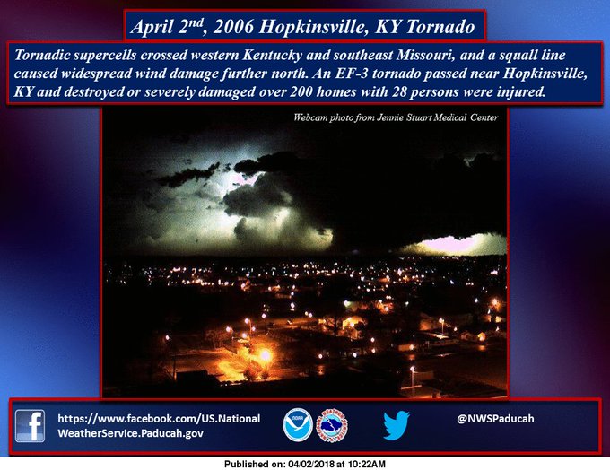
Speaking of tornadoes, on this date in 2006 from the NWS Paducah...
March came in at below normal for the month in Louisville. In fact, several locations in the state had a warmer February than March. There were a total of 54 out of 70 Mesonet sites with a warmer February versus March in addition to the ones I listed in my previous post.
Black Mountain in Harlan county is our precipitation leader for the year at 25.42" while McCreary and Muhlenberg counties come in at 22.11" and 20.30" respectively.
I am going to continue to beat this drum that Black Mountain needs some sort of snow sensor to 'measure' new snowfall and snow depth. I honestly believe Kentucky can break the all-time snow depth record of 31" set in LaGrange (Oldham county). If there would have been a sensor atop Black Mountain back in 1977/1978 when LaGrange registered the state record, I can assure you LaGrange would not be the record holder.
Speaking of snowfall and snow depth, did you know it is still possible to register snowfall in the summer months?
Yes, hail reports are lumped in with any frozen precipitation like snow and ice pellets. Look at these examples...
June 5 and 10, 1951 - hail accumulation of 1" each date at Lubbock TX; 2" of the 7.4" seasonal snowfall was hail accumulation.
June 3, 1959 - hail accumulation of up to 18" occurred in Seldon KS; the small hail pounded the area for 85 minutes; the damage would be the result of not the size but the weight of hail that collapsed several flat-roof structures.
This April 16 will mark the 20th anniversary of Bowling Green's hail storm that devastated the area with baseball-size hail. The regional airport which suffered damage to at least 11 planes recorded a trace of snowfall for that date because the hail accumulation briefly and nearly covered the ground.
Keep safe everyone and have a good week.
MS
Sunday, April 1, 2018
March Colder Than February?
A special post today. Only for unusual activity will I post other than Monday. And, well, today I noticed something unusual.
Reviewing the month of March, which was not a top ten coldest month, Louisville still finished below normal for the 3rd time in 4 months. But, that's not what I thought was unusual.
Typically, the month of February is cooler than March in any given year. However, since we in Lexington had its 2nd warmest February, the ho-hum month of March that finished 2.5 degrees below normal was not enough to beat February's average temperature of 44.9 degrees. In fact, March came in at 43.0 degrees, so it was not really close at all.
Louisville eeked out a March just slightly warmer than February, and I do mean slightly. The 0.3 degree difference (45.3 to 45.0) was the closest February has come to tying or beating March's average temperature since 1960, when February was actually warmer than March that year. Nearby Bowman Field had a closer difference of 0.1 degree warmer March than February.
Bowling Green, Frankfort, Jackson (Feb +3.5 degrees warmer than March), London, and Covington all finished with a warmer February over March this year.
MS
Reviewing the month of March, which was not a top ten coldest month, Louisville still finished below normal for the 3rd time in 4 months. But, that's not what I thought was unusual.
Typically, the month of February is cooler than March in any given year. However, since we in Lexington had its 2nd warmest February, the ho-hum month of March that finished 2.5 degrees below normal was not enough to beat February's average temperature of 44.9 degrees. In fact, March came in at 43.0 degrees, so it was not really close at all.
Louisville eeked out a March just slightly warmer than February, and I do mean slightly. The 0.3 degree difference (45.3 to 45.0) was the closest February has come to tying or beating March's average temperature since 1960, when February was actually warmer than March that year. Nearby Bowman Field had a closer difference of 0.1 degree warmer March than February.
Bowling Green, Frankfort, Jackson (Feb +3.5 degrees warmer than March), London, and Covington all finished with a warmer February over March this year.
MS
Monday, March 26, 2018
MikJournal Monday 03/26/2018...News and Stats
Good Monday to you. Today's post is all about numbers and interesting briefs. So, let's get to it.
According to the CPC, the 10-day period from March 31 - April 9 is expected to be below normal for temperatures and above normal for precipitation in Kentucky.
Islip on Long Island in New York has already recorded 31.9" of snowfall this month, its snowiest March ever and its 2nd snowiest month on record behind the 34.4" that fell in January 2011. The climate record goes back to the mid 1960's.
While we're in New York, the Tug Hill region, notorious for lake-effect snow amounts is at it again. If you look at the blog, the Lake Effect Snow Machine is dominated by several locations in the Tug Hill area, including Hooker's 264.8" seasonal total.
Despite the impressive amount of Nor'easters in a short period of time, much of New England has not recorded too many all-time seasonal totals. Rowe, MA has received over 122" for the snow season going back to July 1, an all-time record, but their reporting time only goes back a few years.
Farther south, in Glenmoore PA, 21" has been recorded this month, making it the snowiest March since records were kept beginning in 1960.
Accumulated snowfall over time generally produces snow depth. As long as temperatures remain cold enough to prevent minimal melting, additional snowfall can produce greater snow depths. Looking at some state records, Colorado recorded its greatest snow depth of 251" in March. Tennessee recorded 63" at Mt. Leconte again during March. Snowshoe in West Virginia recorded 62" during March. Now, these were all mountain locations.
Time to rant. If you read my blog long enough, you already know I will get in one of these moods.
Do you know what the state record for snow depth in Kentucky is? It's 31", set in 1978 at LaGrange, a town just northeast of the Heat Island Capital of the United States here in Louisville. No mountains, just a few knobs.
The other day, I was using some data from the Jackson NWS office and saw a whopping 79" snow depth near Booneville KY. What?! How is this not a record? It was from the year 2000. Now, I am going to post a partial copy of this climate data chart from February 2000 for Booneville.
Climatological Data for BOONEVILLE 12SW, KY - February 2000
Now, I know the chart may be a little cramped. The 'M' just stands for missing data. But, I want you to study the line for February 28, preferably the last two columns that read '27' and '79'. Those 2 columns represent 'New Snow' and 'Snow Depth' respectively. In other words, it snowed 27" that day, and we had a snow depth of 79" by the end of that day.
Something is not right about this. First, it would be a new 24-hour snowfall record that would replace the 26" that fell at Simers in March of 1942. And the 79" snow depth should replace the 31" snow depth at LaGrange from 1978.
Something else seems a bit quirky about the 79" snow depth. Look at the high temperatures for the previous 4 days. All of them in the 70's. One would question how much snow depth was there prior to the 28th. All we see is an 'M'. I do see, however, a possible explanation for the erroneous data.
Take a look at the line above the 28th, yes February 27. Look at the high temperature for the day of 79 degrees the next column over. Somehow, someway, is it possible that data input went into the wrong columns like the New Snow and Snow Depth columns below?
Based on data from surrounding regions, there were other locations that reported similar high temperatures for the dates listed, but for the 28th, no snowfall was recorded. Look at nearby Jackson in Breathitt county...
Even Beattyville in nearby Lee county recorded no snowfall.
Speaking of Beattyville, I found a similar issue. You should have a right to the snow depth record as well. In October 2001, out of the wild blue on the 9th, you recorded a 39" snow depth WITHOUT receiving any new snow for the entire month. In addition, you had a high temperature of 0 degrees and a low temperature of 67 degrees??? Sigh.
However, I do believe the 31" snow depth record for Kentucky can be broken, if it already has not been done. The mountains of Eastern Kentucky would be an excellent place. Did you know that the Kentucky Mesonet has instruments for measuring wind speed, temperature, precipitation, and solar energy atop Black Mountain at an elevation of just over 4,000 feet? Would it not seem reasonable to place a snow sensor of some sort like ones used in other mountainous locations for recording snowfall and depth?
Something to think about. But, being a user of climate data, one would expect the data to be verified for accuracy before putting it to use. The NWS Jackson has additional issues which they are aware of when it comes to climate data. They have assured me that some sort of software problem will be resolved soon. Well, it has not happened yet, and it has been a couple of months. Come on guys, let's get it done. Rant over.
Make it a great week everyone. It might be a little wet, but at least it will be a bit milder.
MS
According to the CPC, the 10-day period from March 31 - April 9 is expected to be below normal for temperatures and above normal for precipitation in Kentucky.
Islip on Long Island in New York has already recorded 31.9" of snowfall this month, its snowiest March ever and its 2nd snowiest month on record behind the 34.4" that fell in January 2011. The climate record goes back to the mid 1960's.
While we're in New York, the Tug Hill region, notorious for lake-effect snow amounts is at it again. If you look at the blog, the Lake Effect Snow Machine is dominated by several locations in the Tug Hill area, including Hooker's 264.8" seasonal total.
Despite the impressive amount of Nor'easters in a short period of time, much of New England has not recorded too many all-time seasonal totals. Rowe, MA has received over 122" for the snow season going back to July 1, an all-time record, but their reporting time only goes back a few years.
Farther south, in Glenmoore PA, 21" has been recorded this month, making it the snowiest March since records were kept beginning in 1960.
Accumulated snowfall over time generally produces snow depth. As long as temperatures remain cold enough to prevent minimal melting, additional snowfall can produce greater snow depths. Looking at some state records, Colorado recorded its greatest snow depth of 251" in March. Tennessee recorded 63" at Mt. Leconte again during March. Snowshoe in West Virginia recorded 62" during March. Now, these were all mountain locations.
Time to rant. If you read my blog long enough, you already know I will get in one of these moods.
Do you know what the state record for snow depth in Kentucky is? It's 31", set in 1978 at LaGrange, a town just northeast of the Heat Island Capital of the United States here in Louisville. No mountains, just a few knobs.
The other day, I was using some data from the Jackson NWS office and saw a whopping 79" snow depth near Booneville KY. What?! How is this not a record? It was from the year 2000. Now, I am going to post a partial copy of this climate data chart from February 2000 for Booneville.
Climatological Data for BOONEVILLE 12SW, KY - February 2000
|
2000-02-23
|
58 | 38 | 48 | 9.7 | 17 | 0 | 0 | M | M |
|
2000-02-24
|
72 | 38 | 55 | 17 | 10 | 0 | 0 | M | M |
| 2000-02-25 | 73 | 42 | 58 | 19 | 7 | 0 | 0 | M | M |
| 2000-02-26 | 78 | 42 | 60 | 21 | 5 | 0 | 0 | M | M |
| 2000-02-27 | 79 | 46 | 63 | 23 | 2 | 0 | 0.2 | M | M |
| 2000-02-28 | M | M | M | M | M | M | 0.1 | 27 | 79 |
| 2000-02-29 | 59 | 24 | 42 | 1.9 | 23 | 0 | 0 | M | M |
Now, I know the chart may be a little cramped. The 'M' just stands for missing data. But, I want you to study the line for February 28, preferably the last two columns that read '27' and '79'. Those 2 columns represent 'New Snow' and 'Snow Depth' respectively. In other words, it snowed 27" that day, and we had a snow depth of 79" by the end of that day.
Something is not right about this. First, it would be a new 24-hour snowfall record that would replace the 26" that fell at Simers in March of 1942. And the 79" snow depth should replace the 31" snow depth at LaGrange from 1978.
Something else seems a bit quirky about the 79" snow depth. Look at the high temperatures for the previous 4 days. All of them in the 70's. One would question how much snow depth was there prior to the 28th. All we see is an 'M'. I do see, however, a possible explanation for the erroneous data.
Take a look at the line above the 28th, yes February 27. Look at the high temperature for the day of 79 degrees the next column over. Somehow, someway, is it possible that data input went into the wrong columns like the New Snow and Snow Depth columns below?
Based on data from surrounding regions, there were other locations that reported similar high temperatures for the dates listed, but for the 28th, no snowfall was recorded. Look at nearby Jackson in Breathitt county...
|
2000-02-23
|
70 | 51 | 61 | 20 | 4 | 0 | 0 | 0 | 0 |
|
2000-02-24
|
71 | 48 | 60 | 18 | 5 | 0 | 0.1 | 0 | 0 |
| 2000-02-25 | 76 | 58 | 67 | 26 | 0 | 2 | 0 | 0 | 0 |
| 2000-02-26 | 78 | 56 | 67 | 25 | 0 | 2 | 0 | 0 | 0 |
| 2000-02-27 | 64 | 42 | 53 | 11 | 12 | 0 | 0.3 | 0 | 0 |
| 2000-02-28 | 57 | 35 | 46 | 3.7 | 19 | 0 | 0 | 0 | 0 |
| 2000-02-29 | 69 | 38 | 54 | 11 | 11 | 0 | 0 | 0 | 0 |
Even Beattyville in nearby Lee county recorded no snowfall.
Speaking of Beattyville, I found a similar issue. You should have a right to the snow depth record as well. In October 2001, out of the wild blue on the 9th, you recorded a 39" snow depth WITHOUT receiving any new snow for the entire month. In addition, you had a high temperature of 0 degrees and a low temperature of 67 degrees??? Sigh.
However, I do believe the 31" snow depth record for Kentucky can be broken, if it already has not been done. The mountains of Eastern Kentucky would be an excellent place. Did you know that the Kentucky Mesonet has instruments for measuring wind speed, temperature, precipitation, and solar energy atop Black Mountain at an elevation of just over 4,000 feet? Would it not seem reasonable to place a snow sensor of some sort like ones used in other mountainous locations for recording snowfall and depth?
Something to think about. But, being a user of climate data, one would expect the data to be verified for accuracy before putting it to use. The NWS Jackson has additional issues which they are aware of when it comes to climate data. They have assured me that some sort of software problem will be resolved soon. Well, it has not happened yet, and it has been a couple of months. Come on guys, let's get it done. Rant over.
Make it a great week everyone. It might be a little wet, but at least it will be a bit milder.
MS
Subscribe to:
Posts (Atom)
-
Recently, I noticed that our days have now begun to shorten. However, our sunset here in Louisville still remains at 9:10pm edt. Starting th...
-
 In July of this year, I did a segment about the latest sunsets in the eastern time zone. This corresponded nicely with the summer solstice a...
 -
Although snow totals were a bit inflated for several locations by the different models, I still believe the amounts I had forecast were not ...
