Welcome to another installment of MikJournal Monday. Unfortunately, I haven't been as regular as I would like to when it comes to posting information.
But this is gardening season. Gotta get the crops in the ground. And lately, well, it's been too cool and damp to suit my taste. So, I am running a little bit behind schedule. But, that's okay. Last year, I did not get all my vegetables in the ground until almost Memorial Day, and I had the best pepper garden ever.
This year, my garden will have these plants: 4 Bell Peppers, 2 Bertha Bell Peppers, 2 Anaheim Chili peppers, 1 Jalapeno pepper, 2 Sweet Banana peppers, 1 Habanero pepper, 2 Zucchini, 1 Yellow Squash, and Tomato.
In addition to the Rosemary that is already in the garden, I also have Thyme in a pot by itself that keeps coming back year after year. I am also supplementing 3 more herbs in a large rectangular pot that will house Cilantro, Spearmint, and Spicy Oregano.
Hopefully, the weather will cooperate. I already have my 66-gallon rain barrel completely full. So, even if I am running low in the rainfall department, I have plenty to draw from to get the plants established.
In Louisville, we are running about 2.5 degrees below average for the month. In fact, the last time Louisville had a monthly temperature below average was May of last year.
The average temperature for the next few days is about 66 degrees here (when you take the high temperature and add the low temperature, then divide by 2). We will be probably be running above the mean at least for a few days before another brief cooldown by this time next week.
Speaking of average temperatures, on the days of May 8-10, our average temperature was supposed to be 65 degrees. Here's how we fared...
May 8th - 8 degrees below average
May 9th - 7 degrees above average
May 10th - 12 degrees above average
Interestingly, that 65 degree average is seen somewhere else besides above or below average statistics. It is also found in the heating and cooling degree days calculation. Primarily used for estimating power and/or fuel consumption for residential and business dwellings, this 65 degree base is used. Any average over 65 degrees counts as cooling degree days and any average below 65 degrees counts as heating degree days. Therefore...
May 8th - 8 heating degree days
May 9th - 7 cooling degree days
May 10th - 12 cooling degree days
Finally, you will notice that I have added another Pick on the side of the blog. It's called TornadoTalk. Usually, I subscribe to the podcasts of all the episodes. I have really enjoyed the podcasts. Even without video, you still capture the human emotion behind the interviews. From an adrenaline rush to compassion to disbelief.
I just recently listened to Episode 30 entitled How Close is Too Close? An excellent panel with storm chasers, emergency management officials, reporters, meteorologists. I discovered a wide range of personal emotions as I listened to how close some are willing to go to get that shot of a tornado doing its thing.
I have listened to at least 4 episodes and have enjoyed every one of them. They also have a twitter feed and a NWS twitter feed from various local offices on their Web site. I highly recommend it!
Have a good week.
MS
Monday, May 15, 2017

Wednesday, May 3, 2017
Worst Tornado Outbreak in Oklahoma History
I recall the date like it was just the other day. But this was 1999, yes, 18 years ago. Thanks to the Southeast Regional Climate Center for their This Day in Weather History, we can revisit these dates of May 3 and 4 and envision the terror of all of those strong tornadoes, the worst outbreak in Oklahoma history.
The Moore, OK tornado was rated an EF-5, and a truck-mounted Doppler radar measured a wind speed of 318 mph, the highest ever observed in a tornado.
Also, I included a podcast from Tornado Talk Episode 2 of a May 4 tornado that struck Greensburg, KS in 2007 leveling nearly the entire town. Enjoy the video...
https://www.youtube.com/watch?v=Wzlr_91GFdo
MS
The Moore, OK tornado was rated an EF-5, and a truck-mounted Doppler radar measured a wind speed of 318 mph, the highest ever observed in a tornado.
Also, I included a podcast from Tornado Talk Episode 2 of a May 4 tornado that struck Greensburg, KS in 2007 leveling nearly the entire town. Enjoy the video...
https://www.youtube.com/watch?v=Wzlr_91GFdo
MS
Sunday, April 30, 2017
A Memorable Storm System
Some in our region may be scratching their heads, wondering what the big deal is about this latest installment of Spring's bag of tricks.
Well, let's look at it from a larger perspective.
First, a warm frontal boundary set up Friday night/Saturday morning, producing an efficient amount of rainfall along either side of that boundary along with some severe weather. Some in our region were negatively impacted with some storm damage reports; however, heavy rain resulted in flash flooding and areal flooding (creeks, rivers overflowing their banks) as the warm front seemed to have difficulty moving northward. It was as if the front stalled for a time as waves of storms kept pounding the same areas over and over again.
Here is a look at some rainfall reports regionally and locally...from Friday night/Saturday morning...
Huntingburg, IN (Dubois County)......8.11"
Evansville, IN.......5.62"
LaGrange, KY.......4.85"
Westport, KY.......4.34"
Indianapolis, IN....2.51"
Cincinnati, OH....2.41"
Around Louisville....
Louisville Int'l (official)....1.20"
New Albany, IN.....5.05"
Transylvania Beach Pumping Station..4.58"
Galena, IN......3.85"
Park Lake, KY....3.54"
Jeffersonville, IN...3.33"
Springhurst, KY....3.28"
In addition to the heavy rainfall, there was a confirmed EF-1 tornado in Goshen, KY in Oldham County and hail up to the size of half-dollar coins in other locations.
On the other side of the cold front now approaching us from the west is a classic Spring 'winter storm'. Parts of Colorado, Wyoming, and now Kansas and Nebraska are dealing with blizzard conditions and heavy snowfall.
Check out some of these snowfall amounts....thru Saturday morning
Colorado City, CO......24.0"
Golden, CO......11.1"
Boulder, CO...8.0"
Keyes, OK...8.0"
Santa Fe, NM....7.0"
Amarillo, TX...3.0"
In Amarillo, just a week earlier, temperatures were flirting with 90 degrees again. Yes, shortly after the middle of the month, they already hit 90.
Snowfall is expected to continue into parts of the Plains. High winds coupled with the heavy snowfall may lead to power outages for some residents along with reduced visibilities and traffic headaches.
Locally, along this cold front, a shield of rain along with isolated severe storms are forecast. This may aggravate already saturated grounds for those that have already received several inches.
MS
Well, let's look at it from a larger perspective.
First, a warm frontal boundary set up Friday night/Saturday morning, producing an efficient amount of rainfall along either side of that boundary along with some severe weather. Some in our region were negatively impacted with some storm damage reports; however, heavy rain resulted in flash flooding and areal flooding (creeks, rivers overflowing their banks) as the warm front seemed to have difficulty moving northward. It was as if the front stalled for a time as waves of storms kept pounding the same areas over and over again.
Here is a look at some rainfall reports regionally and locally...from Friday night/Saturday morning...
Huntingburg, IN (Dubois County)......8.11"
Evansville, IN.......5.62"
LaGrange, KY.......4.85"
Westport, KY.......4.34"
Indianapolis, IN....2.51"
Cincinnati, OH....2.41"
Around Louisville....
Louisville Int'l (official)....1.20"
New Albany, IN.....5.05"
Transylvania Beach Pumping Station..4.58"
Galena, IN......3.85"
Park Lake, KY....3.54"
Jeffersonville, IN...3.33"
Springhurst, KY....3.28"
In addition to the heavy rainfall, there was a confirmed EF-1 tornado in Goshen, KY in Oldham County and hail up to the size of half-dollar coins in other locations.
On the other side of the cold front now approaching us from the west is a classic Spring 'winter storm'. Parts of Colorado, Wyoming, and now Kansas and Nebraska are dealing with blizzard conditions and heavy snowfall.
Check out some of these snowfall amounts....thru Saturday morning
Colorado City, CO......24.0"
Golden, CO......11.1"
Boulder, CO...8.0"
Keyes, OK...8.0"
Santa Fe, NM....7.0"
Amarillo, TX...3.0"
In Amarillo, just a week earlier, temperatures were flirting with 90 degrees again. Yes, shortly after the middle of the month, they already hit 90.
Snowfall is expected to continue into parts of the Plains. High winds coupled with the heavy snowfall may lead to power outages for some residents along with reduced visibilities and traffic headaches.
Locally, along this cold front, a shield of rain along with isolated severe storms are forecast. This may aggravate already saturated grounds for those that have already received several inches.
MS
Friday, April 28, 2017
Lots of Rain and Some Severe Storms
Analogs show modest chances for severe storms in our region through this evening. Should be right along warm front and just south.
However, SPC is having a hard time pinpointing exactly where who is going to get what and when.
Perhaps that explains why the SPC has broadbrushed a large swath of the Plains and OV with an enhanced risk for severe storms. Uncertainty.
Nevertheless, there should be enough rainfall this weekend that should prompt many flash flood and areal flood products to be issued.
I would not be surprised if some places in Kentucky and southern Indiana receive more than 4" this weekend.
I will be posting any extraordinary wind gusts and storm reports of severe criteria hail in a separate post if needed. But, I'll be focusing on the heavy rain reports for the most part.
MS
However, SPC is having a hard time pinpointing exactly where who is going to get what and when.
Perhaps that explains why the SPC has broadbrushed a large swath of the Plains and OV with an enhanced risk for severe storms. Uncertainty.
Nevertheless, there should be enough rainfall this weekend that should prompt many flash flood and areal flood products to be issued.
I would not be surprised if some places in Kentucky and southern Indiana receive more than 4" this weekend.
I will be posting any extraordinary wind gusts and storm reports of severe criteria hail in a separate post if needed. But, I'll be focusing on the heavy rain reports for the most part.
MS
Friday, April 14, 2017
A/C Time
The filter has been changed. Forecast for above 80 degrees today. Yep, it's that time. The A/C is coming on for the first time this season...well, maybe later today when I'm cooking.
Unfortunately, I cannot open the windows since the family struggles with allergy issues. Plus, I cut the front and back yard yesterday.
Remember, for yourself or your family members, after being outside during the pollen season for a significant period of time, the clothes we wear, yes, our hair and skin all collect pollen. If we do not take the time to change out of our clothes or take a brief shower, then we can transfer that pollen into the home, getting it on our pillows, furniture, and so forth.
Still, I love Spring. Soon, I'll be out there clearing out the garden, prepping the soil for planting my peppers and tomatoes along with some zucchini and yellow squash. Hey, my rosemary plant survived the winter for the first time in 3 years, or since I first started growing it in my garden. I still have to check on my thyme. I grow that one in a pot, but it came back last year, so, maybe it will come back again.
One other thing. My rain barrel will be operational by the end of the weekend. Hopefully, the showers we get will fill the 66 gallon reservoir, ready for dispensing come gardening season (right around the first Saturday of May).
MS
Unfortunately, I cannot open the windows since the family struggles with allergy issues. Plus, I cut the front and back yard yesterday.
Remember, for yourself or your family members, after being outside during the pollen season for a significant period of time, the clothes we wear, yes, our hair and skin all collect pollen. If we do not take the time to change out of our clothes or take a brief shower, then we can transfer that pollen into the home, getting it on our pillows, furniture, and so forth.
Still, I love Spring. Soon, I'll be out there clearing out the garden, prepping the soil for planting my peppers and tomatoes along with some zucchini and yellow squash. Hey, my rosemary plant survived the winter for the first time in 3 years, or since I first started growing it in my garden. I still have to check on my thyme. I grow that one in a pot, but it came back last year, so, maybe it will come back again.
One other thing. My rain barrel will be operational by the end of the weekend. Hopefully, the showers we get will fill the 66 gallon reservoir, ready for dispensing come gardening season (right around the first Saturday of May).
MS
Tuesday, April 11, 2017
Remembering the Palm Sunday Tornado Outbreak of 1965
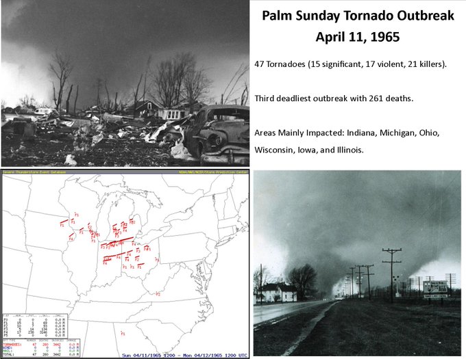
Also, I provided an excerpt from Ohio History Central...
Click here.
The infamous twin twisters from the photograph above occurred in Dunlap, IN. I found a reference from the South Bend Tribune that includes a riveting, yet sad report of what transpired that day.
One of the famous quotes came from a weather observer from the U.S. Weather Bureau in South Bend when he said, "Reports of tornadoes and funnel clouds have become so numerous that it is impossible to keep track of them."
Read more from this reference here.
From the NCDC Storm Publication comes this excerpt from Ohio, in Lorain and Cuyahoga Counties....
The arrival of the tornado occurred here shortly after 11pm, yes, a nightfall event. In fact, all 57 (according to NCDC Storm Publication) deaths in Ohio occurred after 9pm as these tornadoes pummeled the landscape.This tornado was one of the most destructive of those occurring on Palm Sunday because it passed through a more populous section. It first touched down a short distance west of Pittsfield where it completely obliterated this crossroads community. Four people were killed in the ruins. It then proceeded east-northeastward just north of La Grange over the southern edge of Grafton and through Columbia Station and Strongsville. In each of these places there were additional fatalities bringing the total to 18. Property damage to homes, barns, and other structures ran into the millions. For example, 18 homes were leveled in Strongsville and 50 more were badly damaged along with two churches and a school building.
The Palm Sunday tornado outbreak of 1965 will always be remembered, not just in Ohio, but the other 5 Midwest states as well, including Indiana who suffered the most loss of life that day than the other affected states.
MS
Wednesday, April 5, 2017
Dangerous Weather Today
Large hail and a few tornadoes are possible, greatest threat in central Kentucky, ground zero could be south central Kentucky.
CIPS analogs and SPC support the severe weather threat. Again, the potential is there. As always, a bust factor is involved.
Personally, in my opinion, this event has been well advertised. I do expect severe weather reports to be numerous today, with tornado and hail reports.
However, if the storms become severe to our south in Tennessee, this may limit overall severe coverage in Kentucky.
But don't rely on this. Always prepare for the worst and hope for the best.
This is a storm spotter day and weather radios should be on standby. Stay safe.
I am out of town but will be following the action throughout the day.
MS
CIPS analogs and SPC support the severe weather threat. Again, the potential is there. As always, a bust factor is involved.
Personally, in my opinion, this event has been well advertised. I do expect severe weather reports to be numerous today, with tornado and hail reports.
However, if the storms become severe to our south in Tennessee, this may limit overall severe coverage in Kentucky.
But don't rely on this. Always prepare for the worst and hope for the best.
This is a storm spotter day and weather radios should be on standby. Stay safe.
I am out of town but will be following the action throughout the day.
MS
Subscribe to:
Posts (Atom)
-
Recently, I noticed that our days have now begun to shorten. However, our sunset here in Louisville still remains at 9:10pm edt. Starting th...
-
 In July of this year, I did a segment about the latest sunsets in the eastern time zone. This corresponded nicely with the summer solstice a...
 -
Although snow totals were a bit inflated for several locations by the different models, I still believe the amounts I had forecast were not ...
