Sunday, February 19, 2017

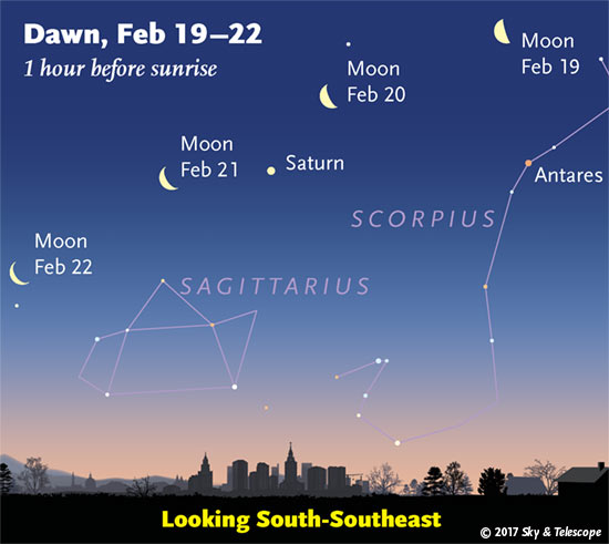
Early Riser...Look to the South-Southeast Sky


Moon, Saturn, Antares and company in early dawn, Feb. 19-22, 2017 and company

Hopefully, skies will remain clear for optimal viewing.

My MikJournal Monday segment comes out tomorrow.

MS

Monday, February 13, 2017

MikJournal Monday 02/13/2017...Severe Stats

January proved to be a violent month of severe weather across parts of the south. Already, there had been 20 tornado fatalities for the month of January. That statistic is more than the total number for all of 2016.


Kentucky
Total Reports = 4
Tornadoes = 1
Hail Reports = 1
Wind Reports = 2


The above map for Kentucky represents preliminary reports of severe weather received so far through February 11.

As you can see, a tornado report was received on February 7 in western Kentucky near Cadiz in Trigg County. According to the Paducah NWS, it was confirmed that an EF-0 tornado caused some damage mainly to trees near the Cadiz area. Some barns were also impacted. In addition, quarter-size to golf-ball size hail was reported in and around the same area.

I am providing a link from the NWS. Click here.

Nationally, the tornado count is way above average. It's still early, but I have been anticipating an active severe weather calendar year. In fact, if you look at the chart below, you will notice that we are already on track to record the most tornadoes since 2008, possibly eclipsing 2011's reports.
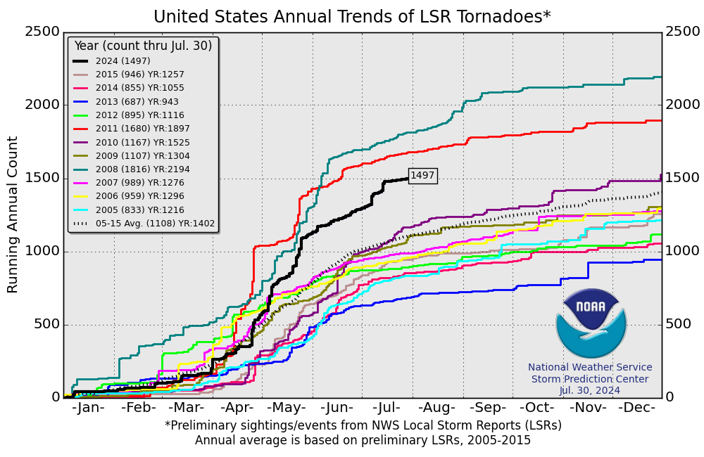
U.S. Annual Tornado Trends

So far this month, I have not read of any fatalities associated with the 20 or so tornado reports, but there have been many injuries, last count was about 36.

Spring seems to be starting earlier this year. Although I am not counting out Winter just yet, the unseasonable warmth will continue to battle with Winter's last gasps leading to severe weather events.

This is now the 2nd time this year I have mentioned the threat for an active severe weather year. Where most of the severe weather will happen nobody knows. But, even California is getting more severe weather reports than usual. Western Kentucky has already recorded a confirmed tornado.

Be prepared. A weather radio is recommended. Keep an eye to the sky. Take an online class or attend one of the Spotter classes to help the NWS know what's happening based on your report from your location. Of course, safety is paramount. Never place yourself directly in harm's way.

While it's nice to get the 'picture' or 'video', immediate relay of information is essential for the NWS to issue statements for adjoining locations in the path of any dangerous storm.

I have been doing this for several years. I have great respect for lightning and high winds. Perhaps it's my age, but my daring adventures of long ago have transitioned to getting reports out as soon as it is safe to do so and communications equipment have not been damaged or disrupted.

Have a safe year, everyone.

MS


Sunday, February 12, 2017

Mount Washington Observatory in New Hampshire

This is one of several favorite locations I use when analyzing weather data. It's claim is 'the world's worst weather'.

I just happened to notice the other day that Mount Washington, at an elevation of 6288 ft, recorded the nation's low temperature at -22 degrees (does not include Alaska).

In addition, winds averaged nearly 70 mph for the day with a peak gust of 120 mph.

Since the average temperature for that day came to -11 (high of -1 and low of -22), and winds averaged nearly 70 mph, the wind chill was a take-my-breath-away -50 degrees.

With the next impending system, snowfall is expected to be in the 2-feet range and, depending on the exact track of the storm system, winds could gust to between 100 and 150 mph.

Check out the site.

https://www.mountwashington.org/

MS

Monday, February 6, 2017

MikJournal Monday 02/06/2017...Data Outlook

I would like to introduce you to some of the tools I use to help provide me with some sort of outlook for the following week to ten days.

Teleconnections:


You have probably heard me harp on teleconnections and their effect on winter. This chart is just one that I follow to give me an idea of any supporting evidence for a blockbuster snow for our region.
Ideally, for me, I like to see a PNA+, NAO-, EPO-, and on another chart, an AO-. I don't use the WPO in my outlook since I have not noticed any significant correlation to this winter.

As of today, February 6, the chart does not show anything significant, except a negative EPO trending positive. That coincides with a shot of cold air invading our region briefly. Could there be a brief spit of snow? There is some support, but the rest of the teleconnections do not support the thought for anything significant. That leads me to the next set of data....

Numerical Models:

I only use the ECMWF High Res, or the European High Resolution model for this outlook. It performs much better than the American models, or at least it's more consistent.

http://meteocentre.com/numerical-weather-prediction/map-explorer.php?mod=ecmwf&run=00&stn=TT850&hh=000&map=na&lang=en&mode=latest&yyyy=latest&mm=latest&dd=latest

I always check out the 7-10 days away part first...I just gotta know. In this case, around February 15, normal to below normal temperatures are expected for our region. Just prior to that, normal to above normal temperatures should prevail. So, it looks to me that no significant snowfall should be anticipated through the middle of the month. Then, I check the remaining current forecast period of 1-6 days out. I noticed below normal temperatures for the time period that does support snow chances later this week, if enough moisture is present. Next, I use analogs.

Analogs:

http://www.eas.slu.edu/CIPS/ANALOG/DFHR.php?reg=SE&fhr=F096&rundt=2017020600&map=COOP2perc

This site helps me determine the potential for at least 2" of snow to occur. So, I use a GFS outlook for the date I am interested. In this case, Thursday. I look at the Hazard Guidance for percentage for at least 2" snow. There is, like I said, some support for snow around that time period, mainly northeast KY, which is only at about a 40% chance of 2" accumulation. Still, flakes could be flying for some of us in our region.

Climate Outlook:

The Climate Prediction Center is a good source for what to expect over the next 6-10 days and 8-14 days. They are usually quite accurate. Just remember, these are percentages, and they represent an average during the selected time period. So, even though it may show a high percentage of above normal temperatures, it could very well be cold for two days in a row at the end of that time period yet still average out above normal for the whole time period selected.

http://www.cpc.ncep.noaa.gov/

I don't want to forget severe weather chances as well. The CIPS page is good for seeing how the top 15 analogs handle our chances here in Kentucky. In this case, not much support at all for severe weather. However, non-thunderstorm winds exceeding 40 mph are bound to cause some local issues. Rainfall chances look heaviest for central and southern Kentucky, exceeding 1", at 60-67%.

In addition, the WPC QPF rainfall estimates for the next 3 days are...0.50 - 1.00", so a little less bullish on totals. Therefore, I would guess at least 0.50" rain for many in our region is a good bet.

The WPC and the NOAA weather home pages are good references I use for my daily updates...
http://www.wpc.ncep.noaa.gov/#page=ovw
http://www.weather.gov/

In fact, I just saw on the WPC home page that Seattle is forecast to get 3-6" snow, quite a bit for them.

The local NWS office says an additional 1-3" is expected today.

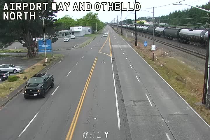
Here is the Seattle Webcam. As I loaded this, it was still dark but one can tell that it is snowing. There should be more daylight very soon.

http://www.earthcam.com/usa/washington/seattle/?cam=seattleskyline
http://www.seattle.gov/trafficcams/images/Airport_S_Othello_NS.jpg

Well, that's all for now. Any updates on high winds and/or severe weather, I'll try and post as soon as these become available. Oh, for an additional resource, check out the Kentucky Mesonet site. Updated wind gusts and rainfall totals will be good pieces of data to check this week.

http://www.kymesonet.org/index.html

MS


Friday, February 3, 2017

North To Alaska


Barrow, AK tied a record high of 26 degrees yesterday. Normal high for the date is -8 degrees. Although temperatures are expected to cool down for the week ahead, normal to even slightly above normal temperatures can be expected.
 
I use Alaska as a barometer for where our weather may be heading. Typically, not always, Alaska's temperatures are generally an inverse of ours.
 
Alaska's temperatures are expected to cool down. Therefore, we can expect another warming trend soon before another blast of cold air tempers the relative warmth, making for more of a 'normal' February for the week ahead.
 
You can check the side of the blog for 'Coldest in Alaska'. I try to update this frequently.
 
MS


Wednesday, February 1, 2017

MikJournal February 2017 Prediction

The pattern is bound to change, right? I mean, if we do not get that pattern change soon, it will be Spring, and we all want Spring to start on time, but it may be cold then. But, quite likely, without the snow. Who wants cold without snow?

February looks to bring the same stuff we've seen so far this winter. Cold spells offset and dominated by warmer spells. And with the intensifying sun angle, if we keep repeating what we've seen the past 2 months, I would expect temperatures to reach the 70's for many in the region sometime this month.

Yes, it's possible to see a brief period of brutal cold and perhaps snow, but don't count on it sticking around for very long.

I have been complaining about the Arctic Oscillation not participating in the 'let's keep a lid on the icebox' scenario. The other teleconnection patterns have not cooperated as well...the NAO, EPO...just not on the same page.

The AO has not dipped below negative for hardly any length of time, if any, since late November. Despite its weakened state, it has been just strong enough to keep the coldest air from making repeated passes into our region. Rather, the Arctic region has experienced the brunt of the coldest air.

Let's hope for that pattern change soon. But, right now, things look the same to me. Even severe weather may be an issue this month. Too much Spring in the air for me to believe Winter wants to stick around.

For what it's worth, and I know we have already heard this song and dance before, but data suggests that the period from mid February through March should come in with below normal temperatures. We'll see.

MS

Top Ten Warmest January's in Our Region

It's hard to believe. Earlier in January, single digit low temperatures and high temperatures struggling to reach the 20's for many in our region, much less the freezing mark for at least 4 days, dominated the weather story. It really looked like January was going into the ice box and a worthy January thumping of snow was destined to occur.

Then...at least 2 consecutive weeks of above normal temperatures and rainfall, that's right, not snowfall, ruined any chance for January to live up to its heavyweight might. It was not only a wimpy winter month, but a top ten warmest January for many in the region.

Here, take a look....

Louisville 41.6 degrees...tied for 7th
Bowling Green 44.2 degrees...7th
Jackson 42.2 degrees...tied 4th
London 42.4 degrees...4th
Evansville, IN 40.1 degrees...9th
Paducah 42.4 degrees...4th
Cape Girardeau, MO 39.6 degrees...5th
Beckley, WV 38.3 degrees...9th
Huntington, WV 42.0 degrees...tied for 8th

What's in store for February? As usual, the cold looks promising, but the pattern change has not happened yet to retain the cold for a prolonged period of time.

Forecast models showed below normal temperatures for 7 consecutive days, at least, to round out the month into the first part of February. Here in Louisville, we have only recorded 2 consecutive days, and the rest has been above average.

Take a look at my February Prediction here on the blog.

MS

Tornadoes on Easter Sunday

This is a worse case scenario. Tornadoes and flooded, blocked roadways making for great difficulties reaching residences affecting hard hit ...